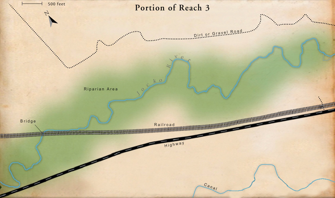
Bridges
A railroad bridge in the lower portion of Reach 3 has caused the channel to become less stable down-stream and to be wider than it would be otherwise. It has also caused gravel bars to form in the channel.
Constructed Levees
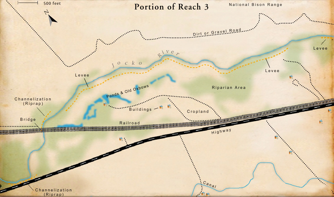
A constructed levee is a ridge or embankment built along the side of a river to keep the river in its channel and prevent it from flowing onto the floodplain during floods. Levees prevent overbank flow from reaching adjacent historical wetland and side-channel features. By limiting the channel’s ability to access the historical floodplain, they interrupt important river processes like the scouring and creation of floodplain surfaces that are colonized by pioneering plants used by certain birds and mammals. They also prevent the flooding of wetlands and the slow release of soil moisture back to the river, the seasonal increase of the water table during flood events, and the retention and cycling of fine sediment and nutrients. All of these processes are vital to healthy fish and wildlife populations.
Sinuosity
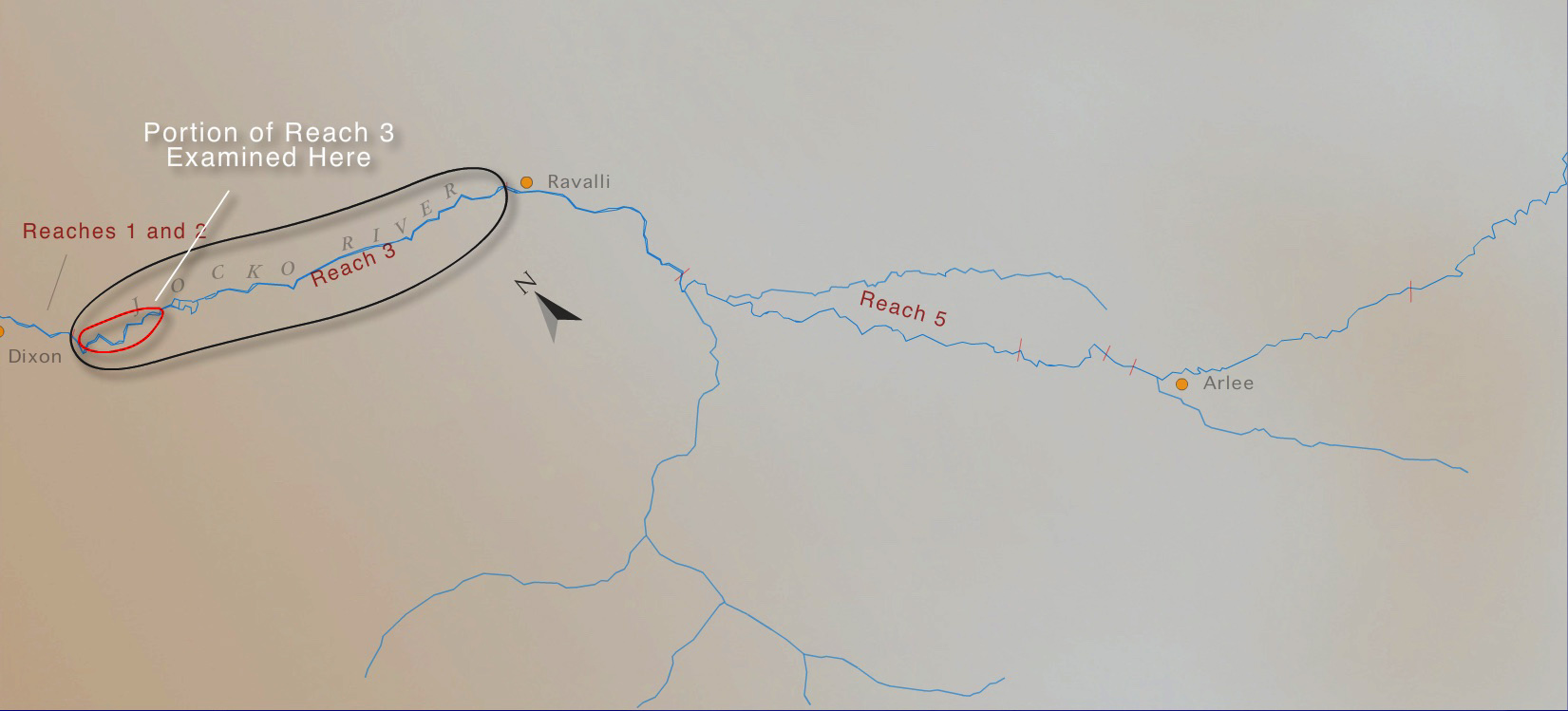
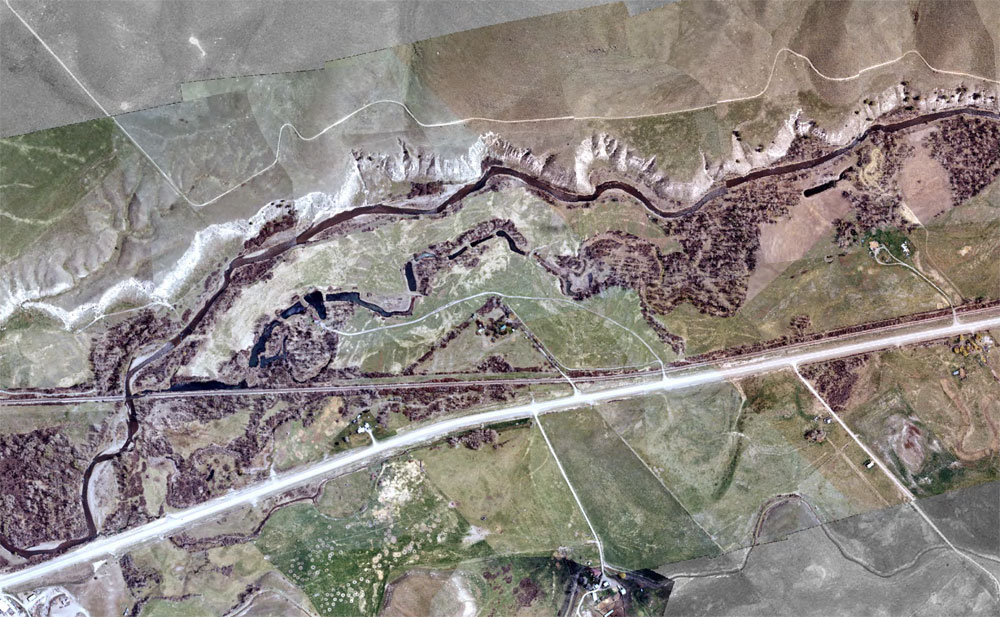
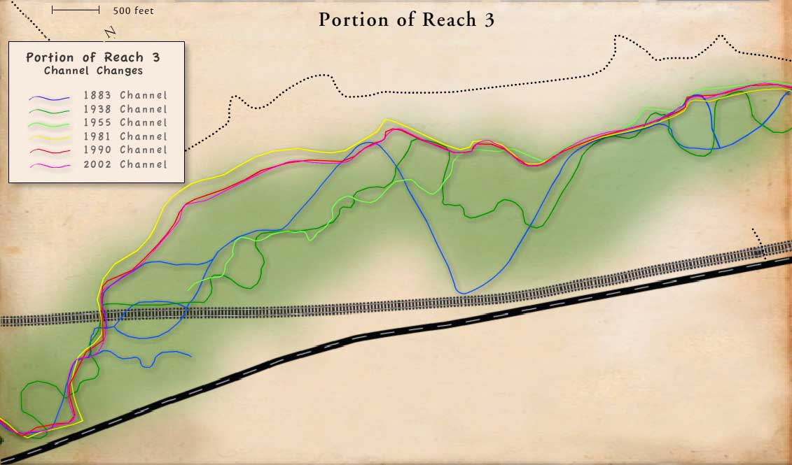
The river channel in Reach Three was once more sinuous (winding) and meandered across the floodplain. Ponds and abandoned oxbows are evidence of this. They mark the historical channel. Some have been used by the land-owner as fish ponds.
Canals
By 1940 most of the major irrigation structures in Jocko Valley had been built. Irrigation withdrawals have reduced the annual occurrence of bankfull flows, mostly during average to below-average water years. In Reach 3, the Lower J Canal diversion has a long stretch of fill adjacent to the river that restricts the extent of the floodplain and has made the channel less stable.
Agriculture
The primary source of disturbance in Reach Three has been agricultural development. To increase agricultural productivity, the river has been straightened and relocated. Floodplain berms adjacent to the southern channel margin of Reach 3 limit overbank flows and have disconnected portions of the river from its floodplain. This has increased instream velocities and channel scour during floods. In places, the conversion of riparian plant communities to agricultural land has reduced the channel’s resistance to bank erosion, decreased shading of the river, and reduced the amount of large woody debris in the river, all of which are bad for native fish.
Channelization
Fifty-five percent of Reach 2 has been channelized, and another 15 percent is affected by constructed levees. Some of the levees are constructed of vehicles cabled together. Although an individual feature like that may not influence overall channel stability, the cumulative effect of numerous channel confinement features can lead to reach-scale channel instability.
Homes
Floodplain encroachment by residential and commercial building has resulted in riparian vegetation being cleared from the floodplain and altered hydrology. Between 1937 and 1962, a number of berms and levees were built to protect residential and agricultural floodplain infrastructure from high water events. This has altered the hydrology of the river, preventing it from accessing the floodplain in many areas.
Riparian Habitat
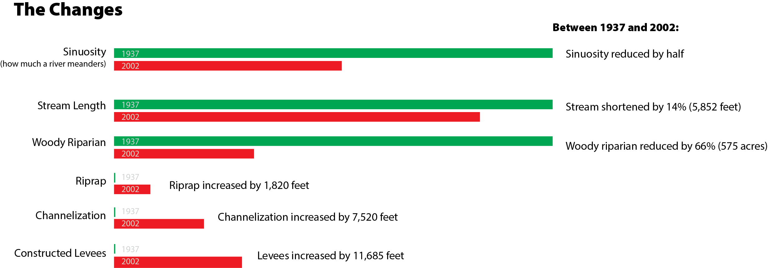
In 2002, only 20 percent of the floodplain was covered by woody riparian vegetation, less than half of what was present in 1937. The loss has adversely affected both fish and wildlife because riparian communities are among the most productive wildife habitats.
Roads
By 2002 a number of low-standard roads had been built within the flood-plain for agricultural and residential purposes. Roads adjacent to the channel intercept and divert overland flows and can separate the river from the floodplain. Unimproved roads can also add sediment to the river, whether or not they are in the floodplain. In places, the highway has separated the river from wetland and riparian communities on the floodplain (although in the short piece of Reach 5 shown here, the highway is a long distance from the river and has minimal impact). Isolating these areas interrupted important river processes vital to fish and wildlife.
Railroad
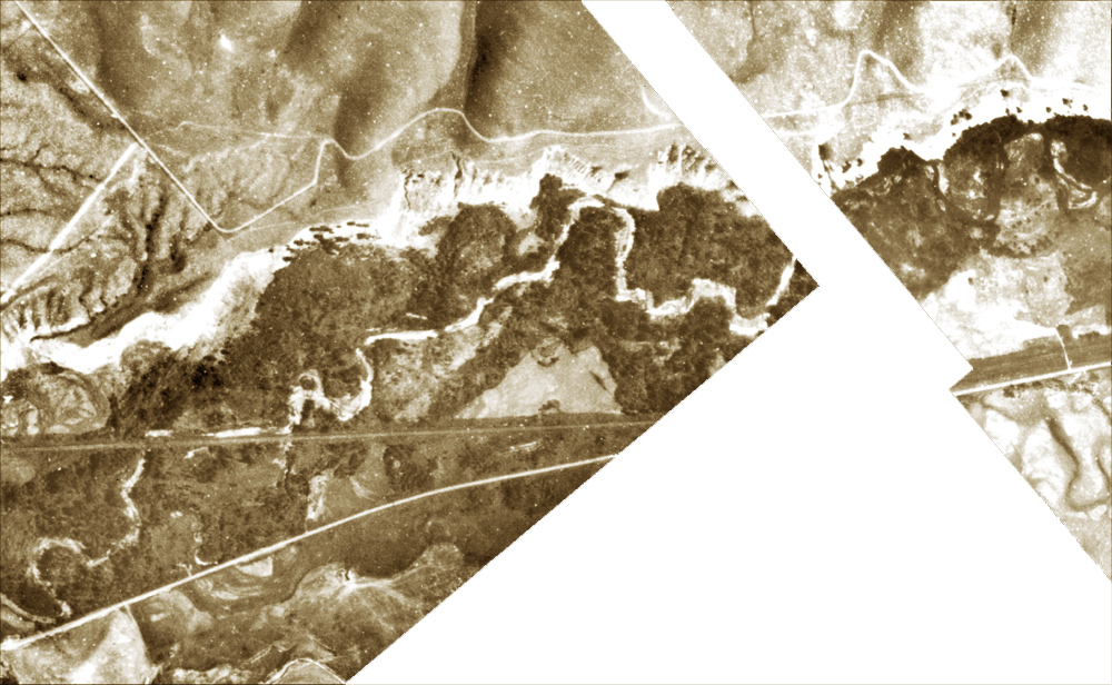
The construction of the railroad in Reach 3 shortened several meanders, which reduced the overall length of the river by about 5,500 feet and de-creased its sinuosity (winding or snakelike pattern). Additional channelization occurred between 1940 and 1960 and these changes are among the dominant disturbances in the reach. The railroad also separated the river from wetland and riparian communities on the floodplain. Isolating these areas interrupted important river processes like the scouring and creation of floodplain surfaces that are colonized by pioneering plants used by certain birds and mammals. It also interrupted the flooding of wetlands and the slow release of soil moisture back to the river, the seasonal increase of the water table during flood events, and the retention and cycling of fine sediment and nutrients. All of these processes are vital to healthy fish and wildlife populations. Many of the seeps in Reach 3 that once contributed to Jocko River floodplain hydrology and associated wetlands were also cutoff from the river and its floodplain by construction of the railroad, another adverse impact on native fish and wildlife populations.
Other
Riprap is material, usually rock, placed on a slope or bank to prevent erosion, keep the stream within its channel, or straighten part of the river. It is also refered to as channelization or bank armoring. Riprap through Reach Three has reduced channel sinuosity (the natural snake-like pattern of a river) and simplified aquatic habitat for fish. Riprap has also increased instream velocities and channel scour during floods, which has contributed to accelerated bank erosion down-stream, localized sediment deposition, and the formation of braided channels.