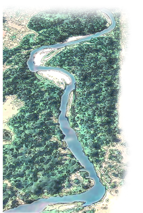
Hydrology : The Parts of a Stream
Hydrology: The Parts of a Stream
Please be patient, letters on the photo take a moment to load.
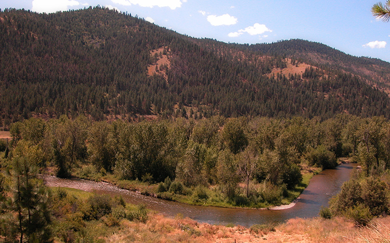
Click on a letter in the image to learn about that part of the stream
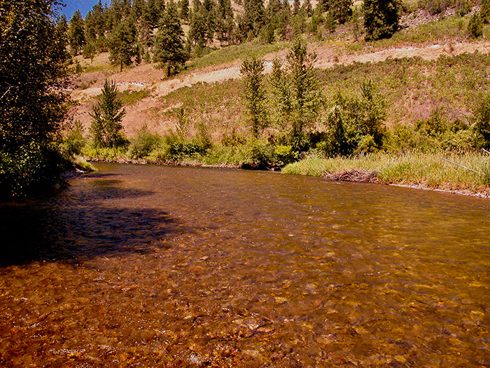
Riffles


Riffles are the short, straight parts of a stream midway between two meanders. Compared to pools, the water is shallow through riffles.
Trout spawning habitat is often found at the head of riffles, and juvenile trout often feed at the downstream end of riffles.

The profile of most streams is broken into a series of alternating segments of high and low gradient, which are riffles and pools, respectively. Riffles are the high points of the stream bed. They help stabilize streams by acting as weirs (low, submerged dams) as stream energy is transferred from pool to pool.
Aquatic insects are well adapted to flowing water and have many strategies to keep from being washed downstream (burrowing, swimming, hooks, claws, suckers, silk threads, and flattened bodies). So the speed of the water is not a limiting factor. On the contrary, species diversity goes up as the speed of the water increases, and riffles typically support the highest aquatic insect biomass, density, and diversity.
Riffles


Riffles are the short, straight parts of a stream midway between two meanders. Compared to pools, the water is shallow through riffles.
Trout spawning habitat is often found at the head of riffles, and juvenile trout often feed at the downstream end of riffles.
Aquatic insects are well adapted to flowing water and have many strategies to keep from being washed downstream (burrowing, swimming, hooks, claws, suckers, silk threads, and flattened bodies). So the speed of the water is not a limiting factor. On the contrary, species diversity goes up as the speed of the water increases, and riffles typically support the highest aquatic insect biomass, density, and diversity.

The profile of most streams is broken into a series of alternating segments of high and low gradient, which are riffles and pools, respectively. Riffles are the high points of the stream bed. They help stabilize streams by acting as weirs (low, submerged dams) as stream energy is transferred from pool to pool.
Riffles


Roll over the image to see where riffles are typically located on a meandering stream.
Riffles are the short, straight parts of a stream midway between two meanders. Compared to pools, the water is shallow through riffles.
Trout spawning habitat is often found at the head of riffles, and juvenile trout often feed at the downstream end of riffles.
The profile of most streams is broken into a series of alternating segments of high and low gradient, which are riffles and pools, respectively. Riffles are the high points of the stream bed. They help stabilize streams by acting as weirs (low, submerged dams) as stream energy is transferred from pool to pool.
Aquatic insects are well adapted to flowing water and have many strategies to keep from being washed downstream (burrowing, swimming, hooks, claws, suckers, silk threads, and flattened bodies). So the speed of the water is not a limiting factor. On the contrary, species diversity goes up as the speed of the water increases, and riffles typically support the highest aquatic insect biomass, density, and diversity.
Pools


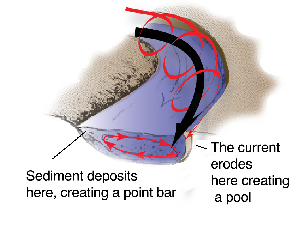
Pools are one of the most important habitat features of a healthy steam. They form on the outside edge of a menader in areas where the stream bottom is more easily eroded. Water is deeper and moves slower than it does in riffles. The surface is also smoother.
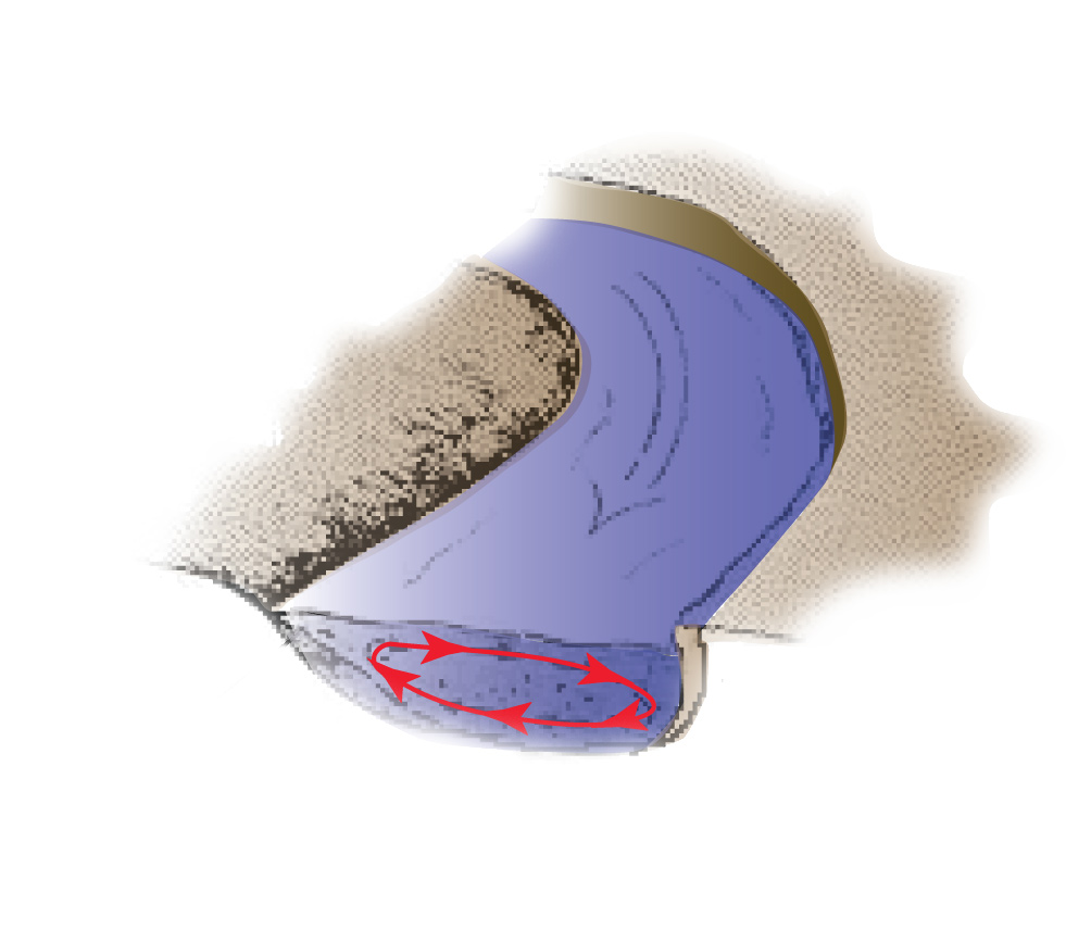
Water moves through a pool in such a way that it erodes on the outside bank and deposits sediment on the inside bank. The red circle of small arrows shows how water circulates within a pool.

The spiraling red line shows the exaggerated path of an imaginary water molecule as it follows a spiral pattern around a meander bend. Over time, those water molecules extend the meander and deepen the pool.
Because the banks are undercut in pool areas, pools are places where large woody debris (logs) gets added to the river. Large woody debris improves habitat for fish. It is essential to a healthy stream, as are pools. Their deep water, undercut banks, and over-head vegetation provide an important haven, especially for large, adult trout.
Pools


Pools are one of the most important habitat features of a healthy steam. They form on the outside edge of a menader in areas where the stream bottom is more easily eroded. Water is deeper and moves slower than it does in riffles. The surface is also smoother.
Because the banks are undercut in pool areas, pools are places where large woody debris (logs) gets added to the river. Large woody debris improves habitat for fish. It is essential to a healthy stream, as are pools. Their deep water, undercut banks, and over-head vegetation provide an important haven, especially for large, adult trout.

Water moves through a pool in such a way that it erodes on the outside bank and deposits sediment on the inside bank. The red circle of small arrows shows how water circulates within a pool.

The spiraling red line shows the exaggerated path of an imaginary water molecule as it follows a spiral pattern around a meander bend. Over time, those water molecules extend the meander and deepen the pool.
Pools


Roll over the image to see where pools are typically located on a meandering stream.
Pools are one of the most important habitat features of a healthy steam. They form on the outside edge of a menader in areas where the stream bottom is more easily eroded. Water is deeper and moves slower than it does in riffles. The surface is also smoother.

Water moves through a pool in such a way that it erodes on the outside bank and deposits sediment on the inside bank. The red circle of small arrows shows how water circulates within a pool.
The spiraling red line shows the exaggerated path of an imaginary water molecule as it follows a spiral pattern around a meander bend. Over time, those water molecules extend the meander and deepen the pool.
Because the banks are undercut in pool areas, pools are places where large woody debris (logs) gets added to the river. Large woody debris improves habitat for fish. It is essential to a healthy stream, as are pools. Their deep water, undercut banks, and over-head vegetation provide an important haven, especially for large, adult trout.
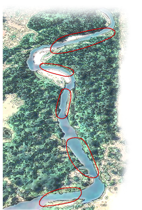
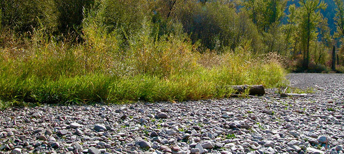
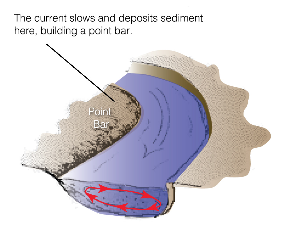
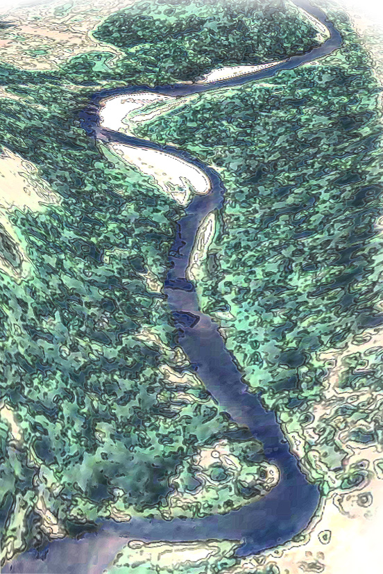
Point Bars


Point bars are the most prominent sedimentary feature of all meandering rivers. Their half-ellipse shape is easily recognizable.

Point bars get their unique, half-ellipse shape because of the way water flows through meanders. As the water enters the bend, the river's flow spins in a spiral strongest on the outside of the bend. As the water flows away from the outer bank it rises up the slope of the inner bank or point bar and loses some of its energy, depositing the sediment it carries.
Point bars provide a surface for pioneering riparian vegetation like willows and cottonwood to get a start. As they grow and mature, some of them will eventually enter the river as large woody debris, providing vitally important habitat for fish and other organisms.
Point Bars


Point bars are the most prominent sedimentary feature of all meandering rivers. Their half-ellipse shape is easily recognizable.
Point bars provide a surface for pioneering riparian vegetation like willows and cottonwood to get a start. As they grow and mature, some of them will eventually enter the river as large woody debris, providing vitally important habitat for fish and other organisms.

Point bars get their unique, half-ellipse shape because of the way water flows through meanders. As the water enters the bend, the river's flow spins in a spiral strongest on the outside of the bend. As the water flows away from the outer bank it rises up the slope of the inner bank or point bar and loses some of its energy, depositing the sediment it carries.
Point Bars


Roll over the image to see where point bars are typically located on a meandering stream.
Point bars are the most prominent sedimentary feature of all meandering rivers. Their half-ellipse shape is easily recognizable.
Point bars provide a surface for pioneering riparian vegetation like willows and cottonwood to get a start. As they grow and mature, some of them will eventually enter the river as large woody debris, providing vitally important habitat for fish and other organisms.
Point bars get their unique, half-ellipse shape because of the way water flows through meanders. As the water enters the bend, the river's flow spins in a spiral strongest on the outside of the bend. As the water flows away from the outer bank it rises up the slope of the inner bank or point bar and loses some of its energy, depositing the sediment it carries.
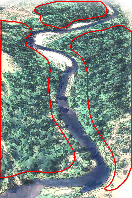
Floodplains


Roll over the image to see where floodplains are located on a meandering stream.
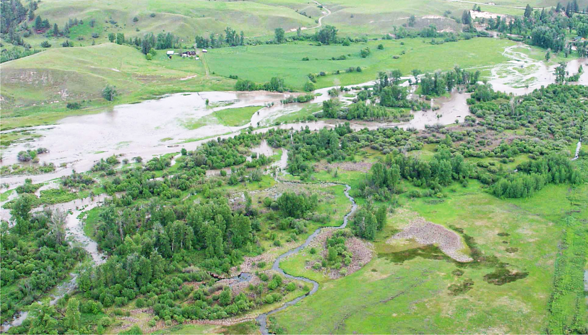
A floodplain is land built of sediment deposited by the river. It is regularly covered with water as a result of flooding. The 100-year floodplain is the area adjacent to a stream that is, on average, flooded once a century. But portions of floodplains are frequently flooded (every 1 or 2 years), and with climate change, the 100-year floodplain is changing significantly for many streams.
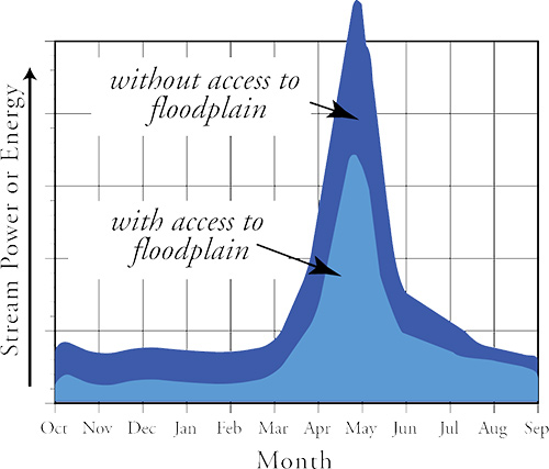
When flood water is able to access the floodplain, it affects the velocity, depth, and slope (stream power) of the flood flow. Loss of floodplain access and function can lead to greater stream power and erosion during floods, which usually results in more damage. It is key that rivers have access to their floodplain and that floodplain is functioning properly.
As water covers the floodplain during a flood, flow velocity decreases. Sediment—fine sands and silts— settle, on the floodplain. These deposits fertilize the soils and promote regeneration and growth of riparian vegetation. Floodplain plants are adapted to periodic floods and even require periodic flooding to sustain them.
Healthy floodplains provide some of the most important wildlife habitat in the Northern Rockies. For example, riparian habitats like those found on the Jocko River floodplain support the highest diversity of breeding birds of any habitats in the western United States.
Floodplains


Roll over the image to see where floodplains are located on a meandering stream.
A floodplain is land built of sediment deposited by the river. It is regularly covered with water as a result of flooding. The 100-year floodplain is the area adjacent to a stream that is, on average, flooded once a century. But portions of floodplains are frequently flooded (every 1 or 2 years), and with climate change, the 100-year floodplain is changing significantly for many streams.
As water covers the floodplain during a flood, flow velocity decreases. Sediment—fine sands and silts— settle, on the floodplain. These deposits fertilize the soils and promote regeneration and growth of riparian vegetation. Floodplain plants are adapted to periodic floods and even require periodic flooding to sustain them.
Healthy floodplains provide some of the most important wildlife habitat in the Northern Rockies. For example, riparian habitats like those found on the Jocko River floodplain support the highest diversity of breeding birds of any habitats in the western United States.

When flood water is able to access the floodplain, it affects the velocity, depth, and slope (stream power) of the flood flow. Loss of floodplain access and function can lead to greater stream power and erosion during floods, which usually results in more damage. It is key that rivers have access to their floodplain and that floodplain is functioning properly.
Floodplains

Roll over the image to see where floodplains are located on a meandering stream.
A floodplain is land built of sediment deposited by the river. It is regularly covered with water as a result of flooding. The 100-year floodplain is the area adjacent to a stream that is, on average, flooded once a century. But portions of floodplains are frequently flooded (every 1 or 2 years), and with climate change, the 100-year floodplain is changing significantly for many streams.
As water covers the floodplain during a flood, flow velocity decreases. Sediment—fine sands and silts— settle, on the floodplain. These deposits fertilize the soils and promote regeneration and growth of riparian vegetation. Floodplain plants are adapted to periodic floods and even require periodic flooding to sustain them.
Healthy floodplains provide some of the most important wildlife habitat in the Northern Rockies. For example, riparian habitats like those found on the Jocko River floodplain support the highest diversity of breeding birds of any habitats in the western United States.

When flood water is able to access the floodplain, it affects the velocity, depth, and slope (stream power) of the flood flow. Loss of floodplain access and function can lead to greater stream power and erosion during floods, which usually results in more damage. It is key that rivers have access to their floodplain and that floodplain is functioning properly.
Uplands
Uplands are all those lands at elevations higher than the floodplain, lands outside the riparian-wetland and aquatic zones.
Wildlife moves freely between upland areas and the floodplain, and many wildlife species play an important role in the ecology of both, as well as the river. So when planning activities that alter the landscape, it is important to think about the entire ecosystem, not just one part of it.


Roll over the image to see where uplands are located on a meandering stream.

Pine marten.
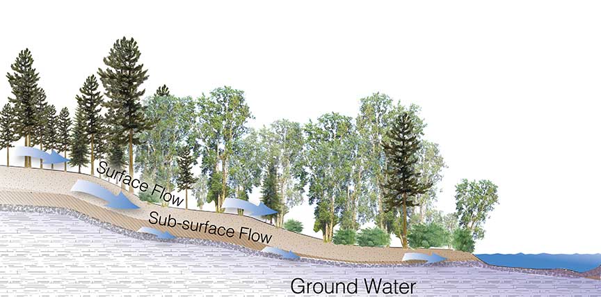
Uplands affect streams because they catch rain and snow that is relased into the stream during spring, summer, and fall. Human impacts and fires in uplands affect the amount, timing, and quality of water entering the stream.
Uplands


Roll over the image to see where uplands are located on a meandering stream.
Uplands are all those lands at elevations higher than the floodplain, lands outside the riparian-wetland and aquatic zones.
Wildlife moves freely between upland areas and the floodplain, and many wildlife species play an important role in the ecology of both, as well as the river. So when planning activities that alter the landscape, it is important to think about the entire ecosystem, not just one part of it.

Uplands affect streams because they catch rain and snow that is relased into the stream during spring, summer, and fall. Human impacts and fires in uplands affect the amount, timing, and quality of water entering the stream.
Uplands
Roll over the image to see where uplands are located on a meandering stream.
Uplands are all those lands at elevations higher than the floodplain, lands outside the riparian-wetland and aquatic zones.
Wildlife moves freely between upland areas and the floodplain, and many wildlife species play an important role in the ecology of both, as well as the river. So when planning activities that alter the landscape, it is important to think about the entire ecosystem, not just one part of it.

Uplands affect streams because they catch rain and snow that is relased into the stream during spring, summer, and fall. Human impacts and fires in uplands affect the amount, timing, and quality of water entering the stream.
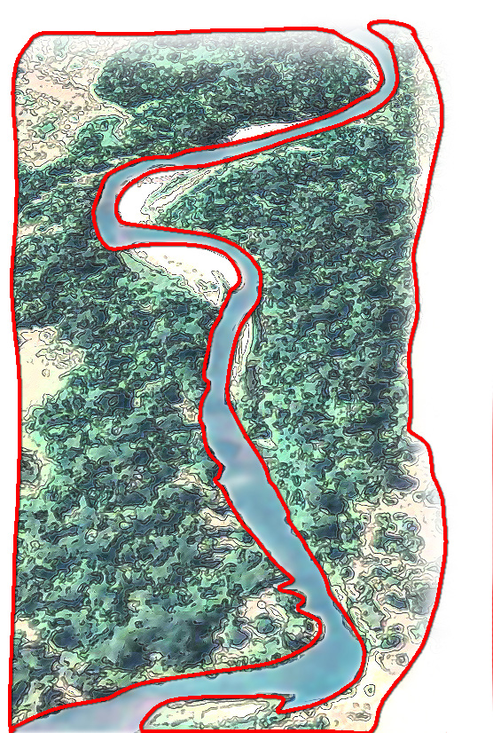
From point bars and pools to riffles and floodplains, a knowledge of the parts of a stream is fundamental to understanding river hydrology and ecology. Explore this scene by clicking on a letter to learn about the basic building blocks of a healthy stream.
From point bars and pools to riffles and floodplains, a knowledge of the parts of a stream is fundamental to understanding river hydrology and ecology. Explore this scene by clicking on a letter to learn about the basic building blocks of a healthy stream.
© 2021 Confederated Salish and Kootenai Tribes | Contact Us
© 2021 Confederated Salish and Kootenai Tribes | Contact Us