
Loading . . .
Interactive Map
Natural and Human History of the River
Interactive Map
The Natural and Human History of the
Lower Flathead River
Interactive Map
The Natural and Human History of the
Lower Flathead River
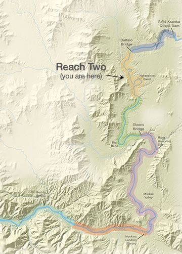
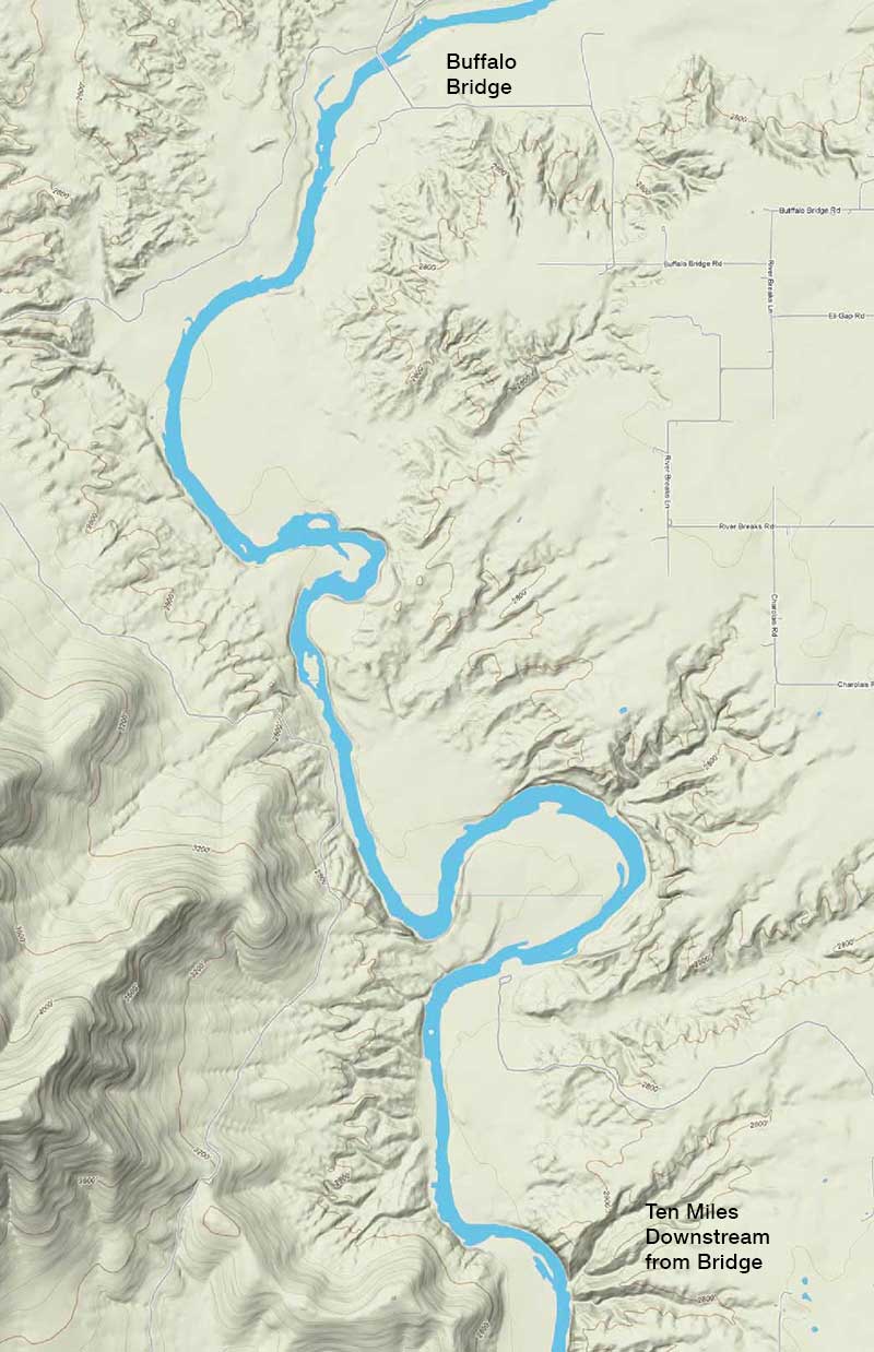
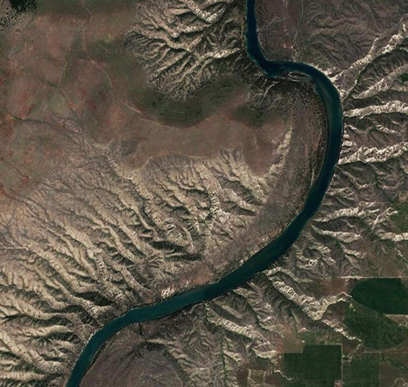
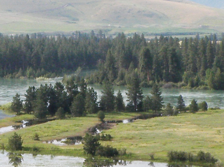
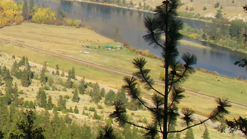
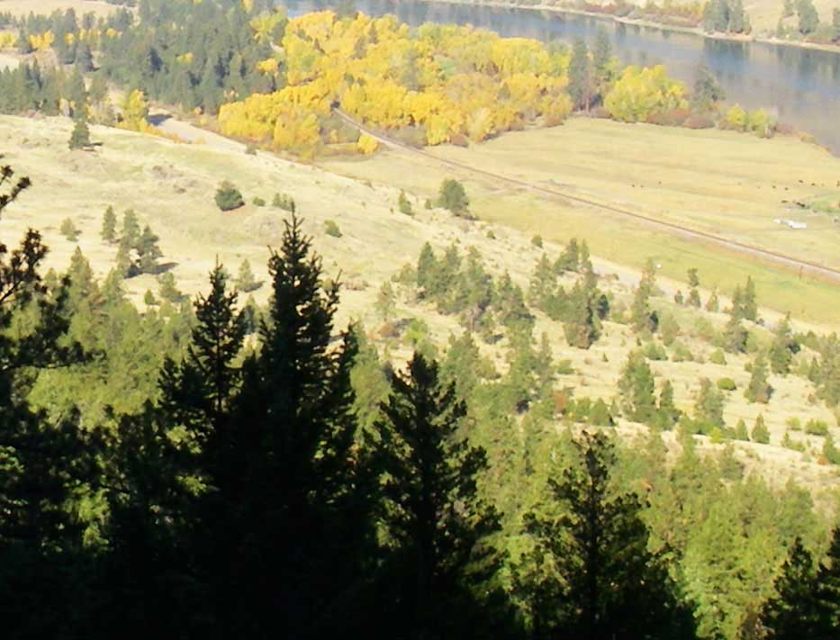
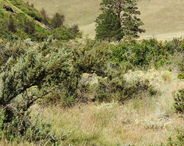
On this page you can explore River Reach Two, which runs from Buffalo Bridge to a point ten miles downstream. The river drops about 3.2 feet/mile and averages just over 400 feet wide. Throughout this reach the river gradually widens, but it maintains a single channel. With the exception of a few small islands and constrictions of the river channel, the flow is a smooth glide. The river makes several large, meandering bends which are bordered by high, eroding clay cliffs. River banks are generally steep with benchlands beyond; the channel substrate ranges from solid bedrock to sizeable areas of silt deposition.
Reach Two
Buffalo Bridge to a Point Ten Miles Downstream of the Bridge
Click a Map Pin
Off-Road Vehicle Use
Spoiling the Beauty
Driving off road is not cool. Tally the damage and you realize just how uncool it is. It damages soils, compacting them, making them less permeable to water and drying them out, making it more difficult for plants to live. It increases erosion, increasing sediment production and destroying fish habitat. It kills vegetation, crushing plants and seedlings. In arid environments like the river corridor, vegetation is more susceptible because plants in dry environments grow slowly and many have shallow root systems. It dramatically reduces the diversity of plant species and increases weeds. Wildlife suffers. And it ruins the beauty of the river corridor. No one likes to look at eroded hillsides and gullies caused by irresponsible people driving off roads. Plus it is illegal. People who drive off roads can receive significant fines and citations. Can you think of other problems that off road driving causes?

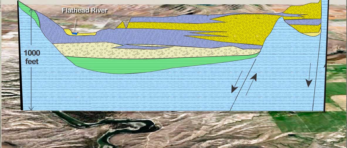
What's Beneath the River and Floodplain
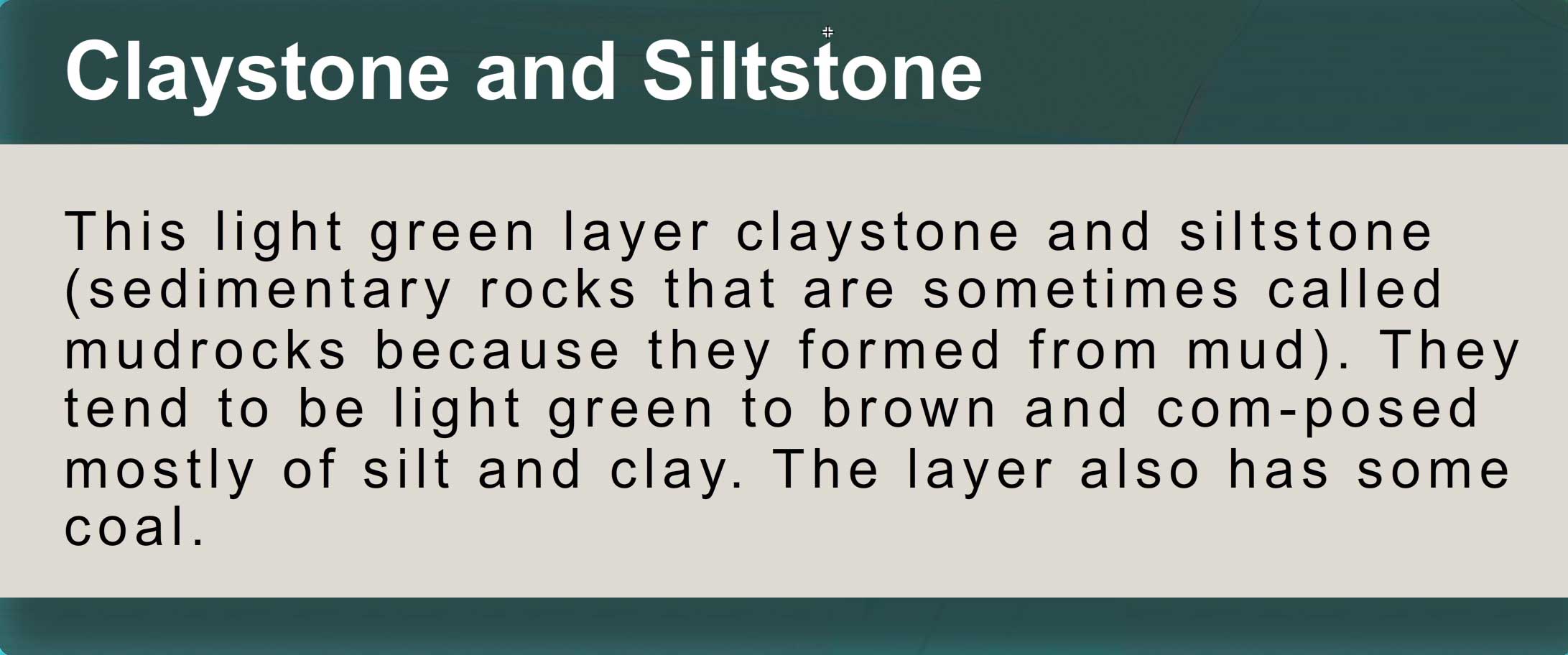
If you could pull up a 1000-foot deep slice of the rocks and sediments under the river, it would look like the slice shown below, which is based mostly on descriptions from the water-well drillers who have drilled wells in the area and who keep logs or diaries about the materials they drill through. This slice is just north of Goose Bend.


Canada Geese
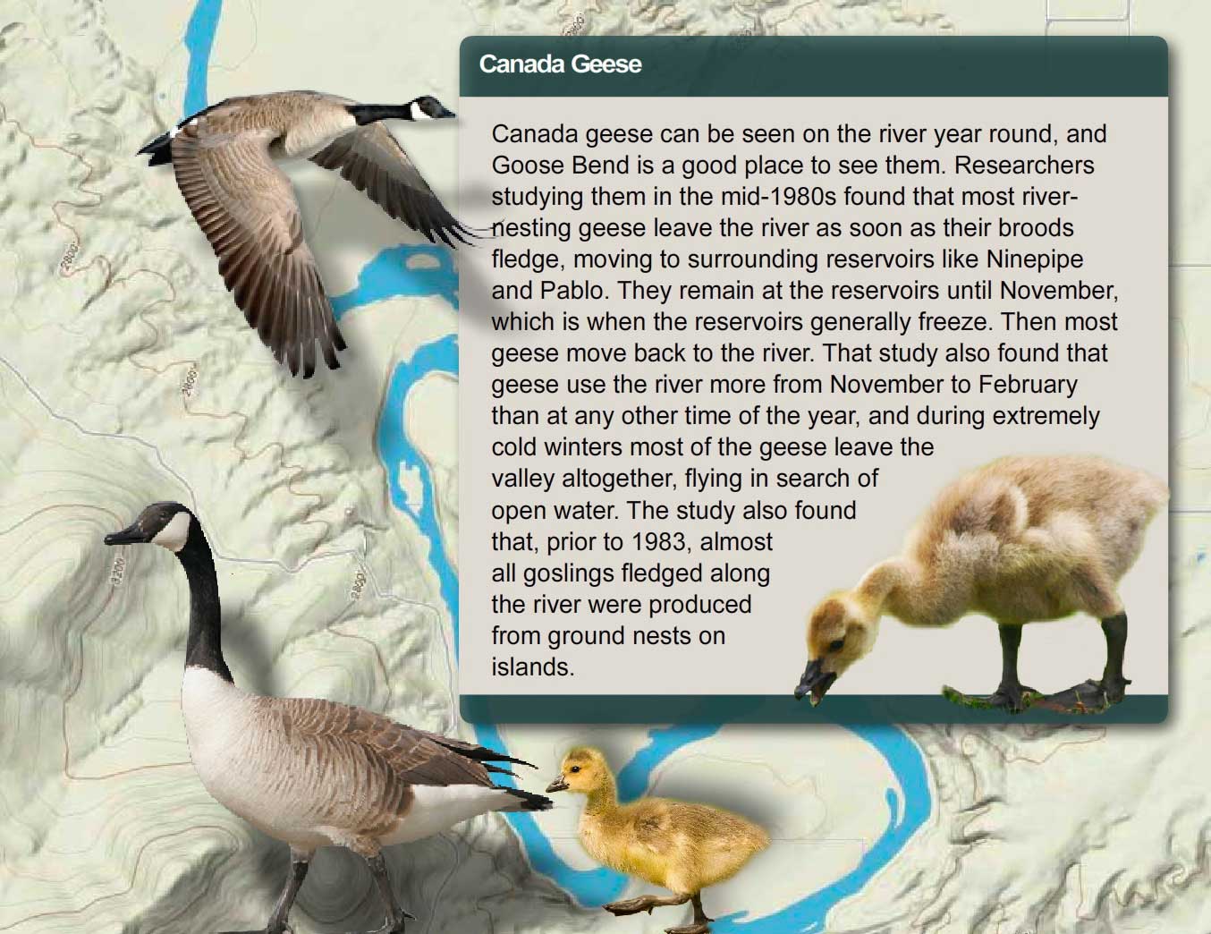
Different subspecies of Canada geese weigh from 3 pounds to 11 pounds. The large-bodied subspecies are mainly continental in distribution. Small-bodied ones breed in coastal Alaska and the Arctic. The subspecies of Canada Geese are listed below.
Large-Bodied Canada Geese
- default_titleAtlantic Canada Geese (Branta canadensis canadensis)
- default_titleHudson Bay or Interior Canada Geese (B. c. interior)
- default_titleGiant Canada Geese (B. c. maxima)
- default_titleWestern or Great Basin Canada Geese (B. c. moffitti)
- default_titleVancouver Canada Geese (B. c. fulva)
- default_titleDusky Canada Geese (B. c. occidentalis)
- Show More
Small-Bodied Canada Geese
- default_titleBaffin Island Canada Geese (Branta canadensis hutchinsii)
- default_titleTaverner’ s or Alaskan Canada Geese (B. c. taverneri)
- default_titleCackling Canada Geese (B. c. minima)
- default_titleAleutian Canada Geese (B. c. leucopareia)
- default_titleLesser or Athabasca Canada Geese (B. c. parvipes)
- Show More
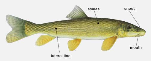
Longnose Suckers
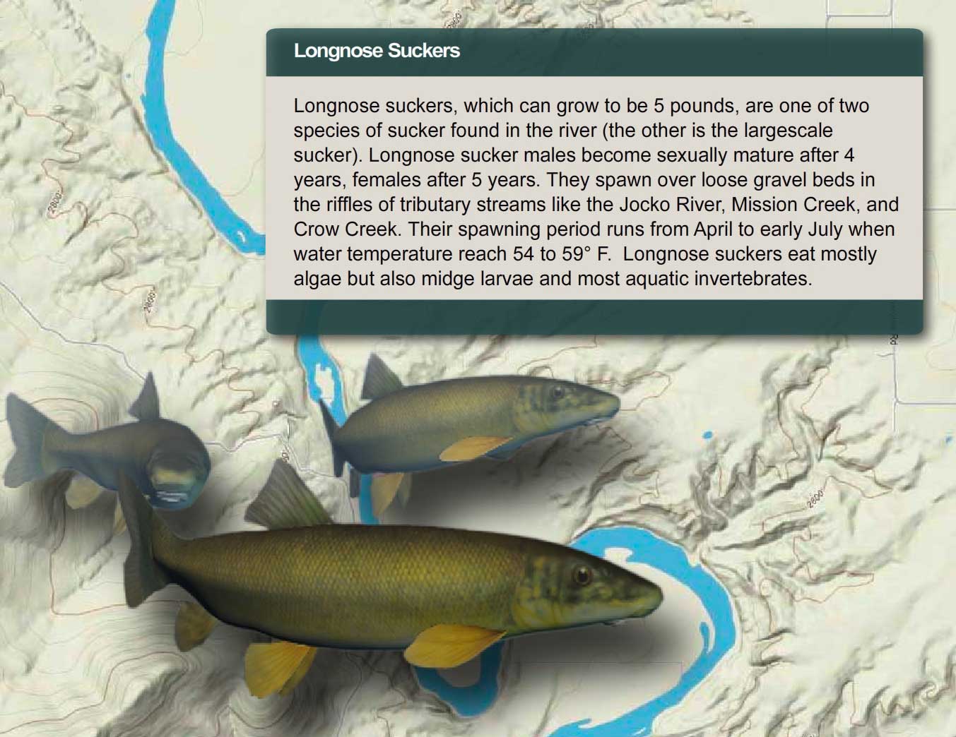
Longnose suckers can be identified by their snout, which is long, their lateral line, which has 95 to 120 scales, their lower lip, which is much wider than high, and their scales, which tend to be small and crowded toward the front.
Discussion Question:
Suckers are an important link in the food chain. They eat both algae and insects that live on the bottom of the river and they themselves are eaten by eagles, osprey, bull trout, and northern pike. The fry or young fish are also an important prey species for fish like northern pikeminnows. When they spawn, they are eaten by bears. They have also been harvested by people—their flesh is firm, white, flaky, and tastes good, though nowadays people seldom fish for them. What do you think would be the consequences if longnose suckers suddenly disappeared from the river?
Decision Point:
If you were the fisheries manager for the river, would you manage for all species of native fish or just the ones anglers like to catch? Why?
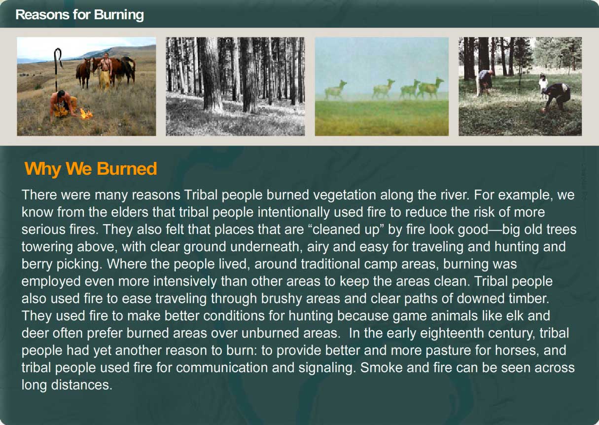
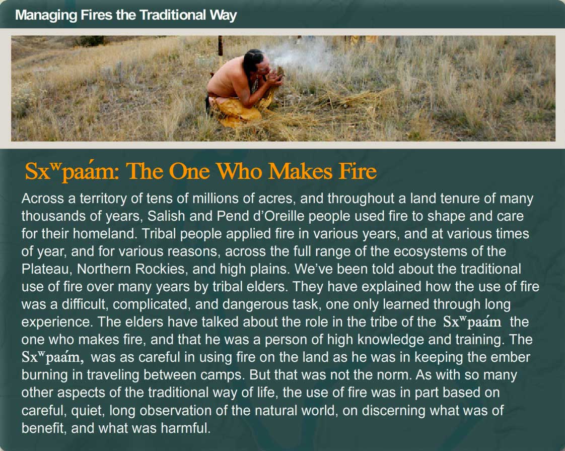
Managing Fires the Traditional Way
- Indian-lit Fires and the River
- The One Who Makes Fire
- Reasons for Burning
- Interview with Tony Incashola
Indian-lit Fires and the River

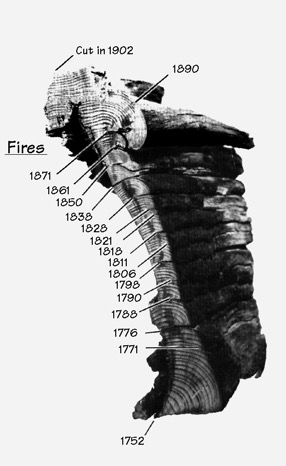
Most of the ancient ponderosas they have studied date to the 1500s, 1600s, or 1700s; a few of the very oldest of the trees began growing in the 1300s and 1400s. Across western Montana in ponderosa forests (and western larch and whitebark pine forest), the rings of the oldest trees show signs of fires at average intervals of between 5 and 25 years, depending on the forest type and elevation. In most places, these fires were far too frequent to have been caused by lightning; the tree rings are direct evidence of Indian use of fire.
This means that for many centuries tribal people set frequent fires along the river and in other places they lived and camped. These fires were not “stand-replacement” fires (fires that killed all the trees in a given area). The old trees survive to this day because the Indian fires were low-intensity fires that did not kill mature ponderosa pine trees, but did remove the brushy undergrowth that, if not removed could threaten them later. The big trees were the result of frequent fires, many of which were set by Indian people.
Discussion Question:
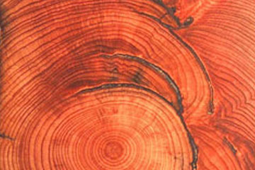
The cross section from a ponderosa pine stump at right reveals old fire scars that show an average fire frequency of one fire every 8.5 years. What do you think the consequences of removing fire (not just wildfires but also Indian-lit fires) from the river corridor is?
Decision Point:
If you were the fire manager for the area, what would you do to improve the situation?
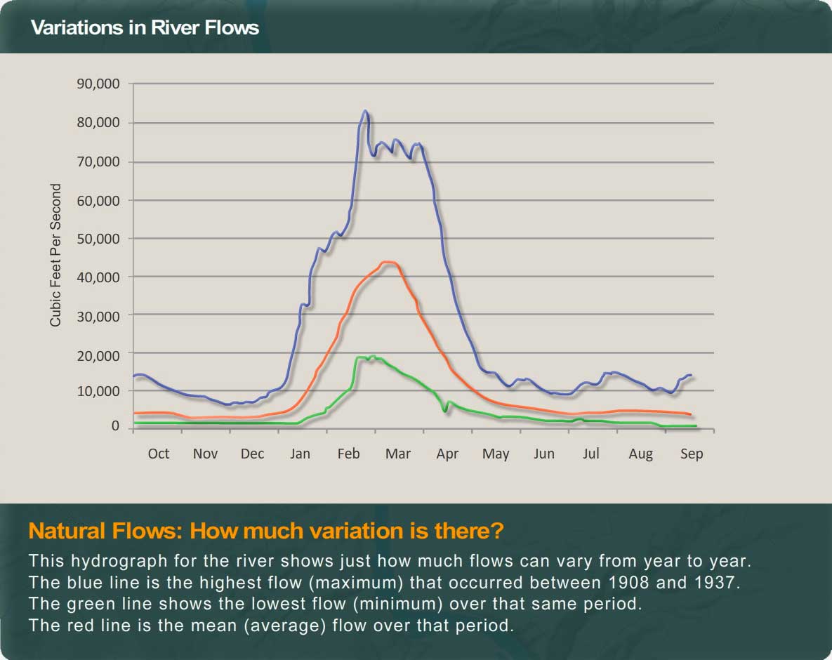
Flows on the Lower Flathead River
River flows can vary dramatically from year to year. The graph below shows that between 1908 and 1937 there was a maximum flow one year that went above 80,000 cubic feet per second. During another year in that period, flows did not go over 20,000 cubic feet per second. So, depending on weather (how much rain and snow the basin receives and what the temperatures are) the river's flows can vary dramatically.
Discussion Question:
River flows affect all kinds of things. They are probably the biggest factor in shaping the river—moving gravel bars, cutting new channels, digging deep pools, etc. They also have an enormous affect on vegetation and fish and wildlife populations. Some species benefit from the scouring that floods cause, for example. What impacts do you think a dam has on river flows? Will a dam make flows more or less stable? What do you think would happen if Se̓liš Ksanka Qĺispe̓ Dam stopped all high flows on the river?
Decision Point:
If you were the manager of Se̓liš Ksanka Qĺispe̓ Dam, what kind of hydrograph would you try to manage for?

What's a Hydrograph
A hydrograph shows the amount of water flowing in a stream over a period of time. One cubic foot per second (cfs) is equal to one cubic foot of water flowing by every second, a rate equivalent to about 7.48 gallons per second. The data for a hydrograph comes from a stream gauge. To read a hydrographic, pick a date and move up to where it intersects the graph. Then read horizontally to the left to the discharge of the stream for that date (click on the graph below for an example of how to read a hydrograph.
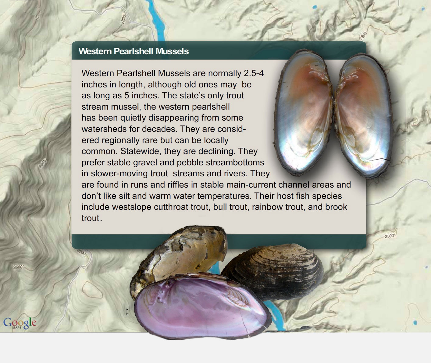
Western Pearlshell Mussels


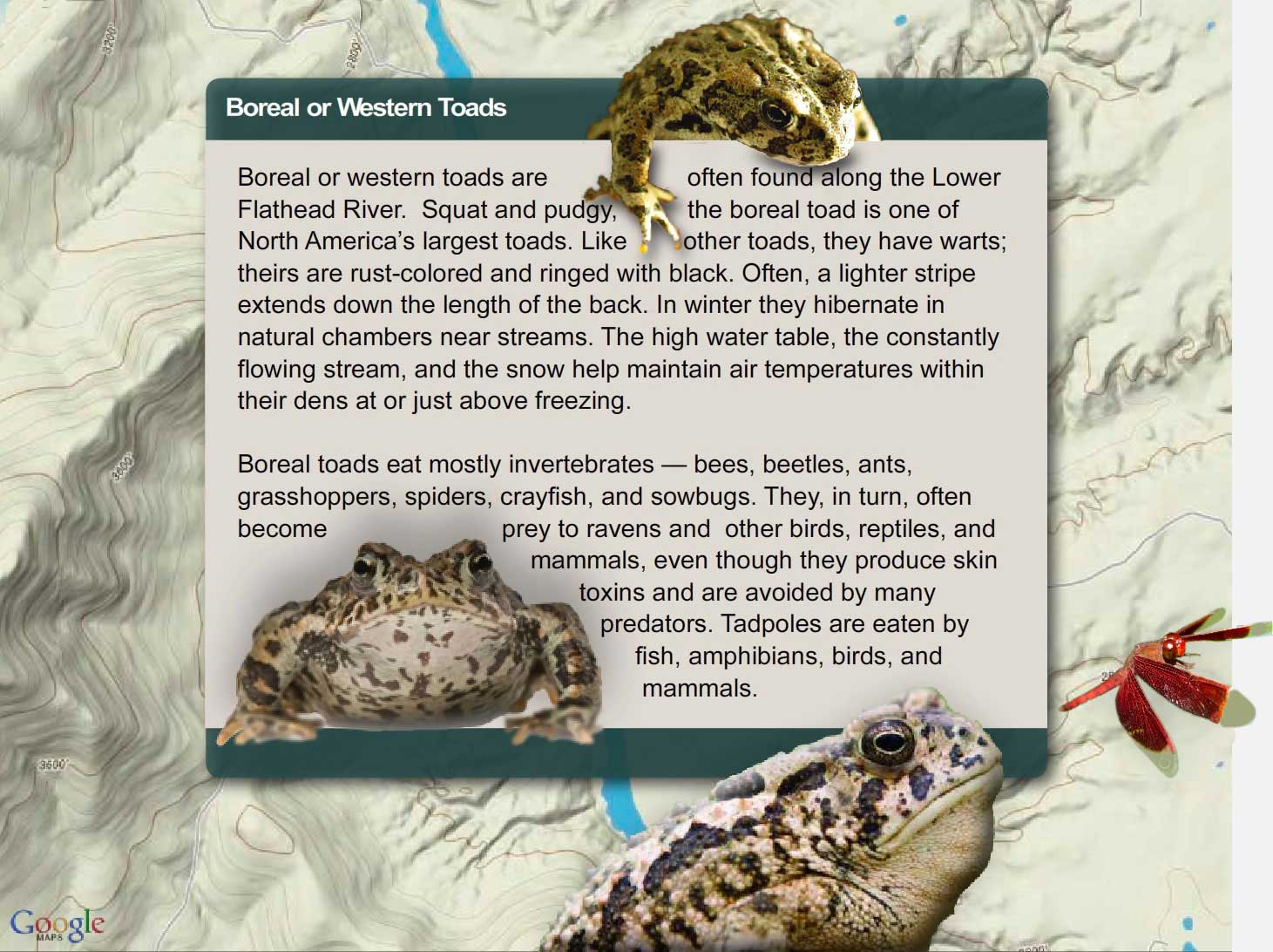
Boreal or Western Toads
Decision Point:
If you were the wildlife biologist in charge of managing wildlife in the river corridor, how would you go about determining the best measures to help boreal toads along the river? Can anything be done?
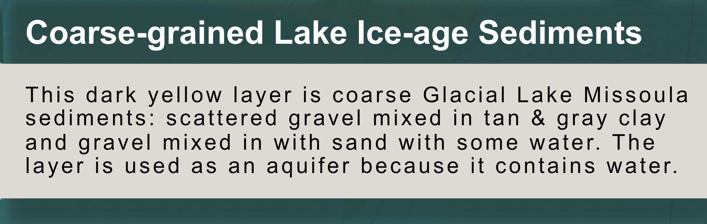
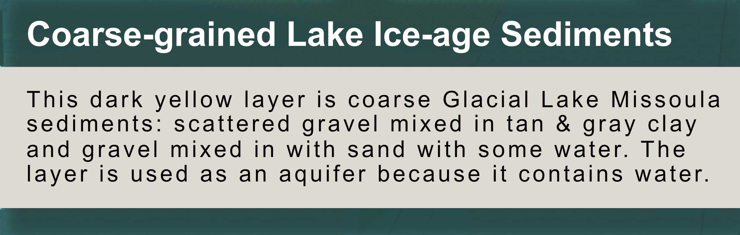
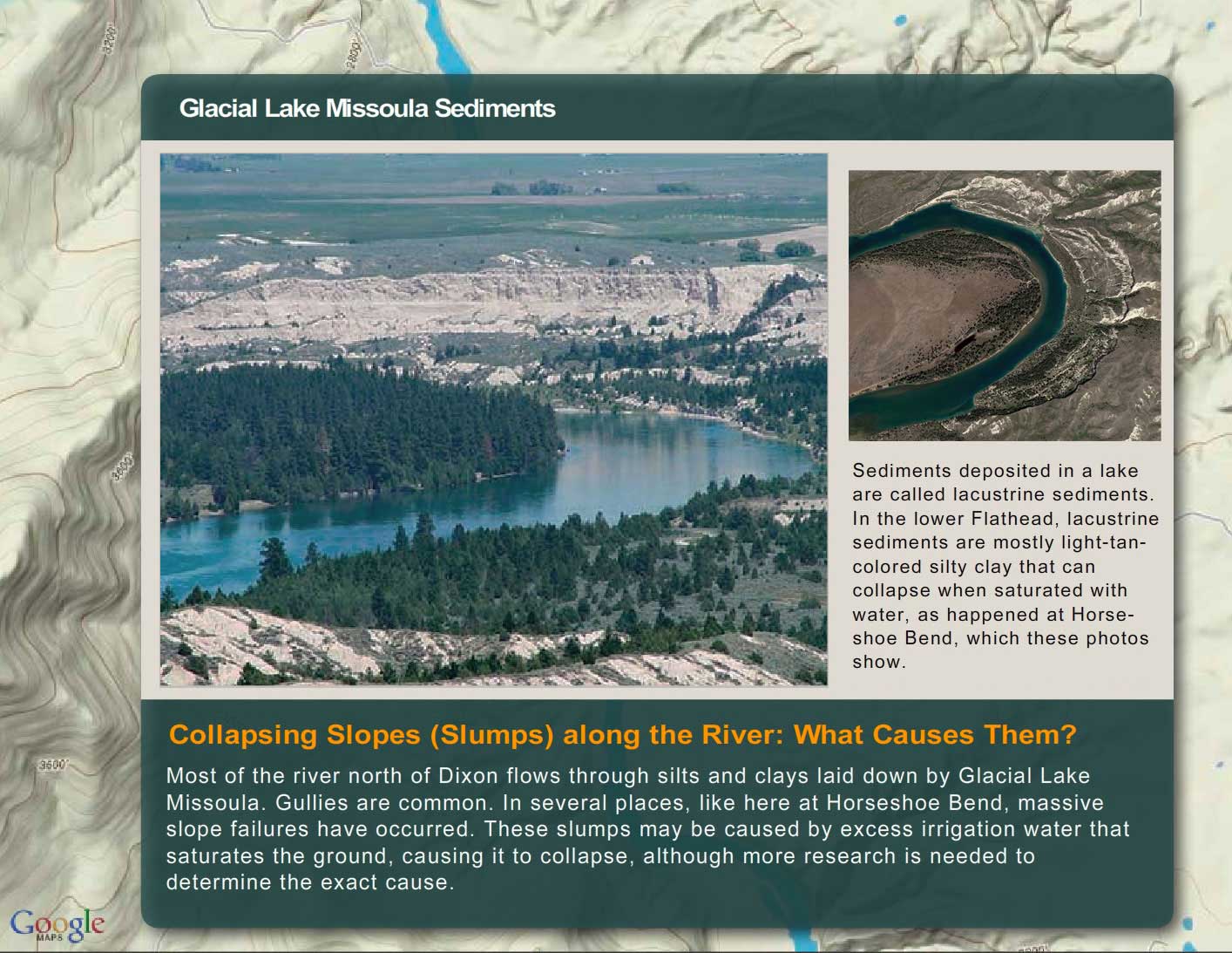
Glacial Lake Missoula Sediments
Decision Point:
If you were a land manager of lower Flathead River corridor, what steps would you take to protect vegetation and reduce unnatural erosion?

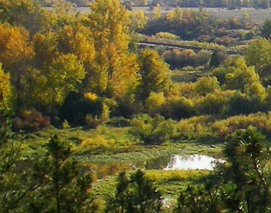
Riparian Vegetation
The term riparian vegetation refers to the plant habitats and communities along the river margins and its banks. Riparian zones are important because so many birds and mammals in western Montana depend on them.
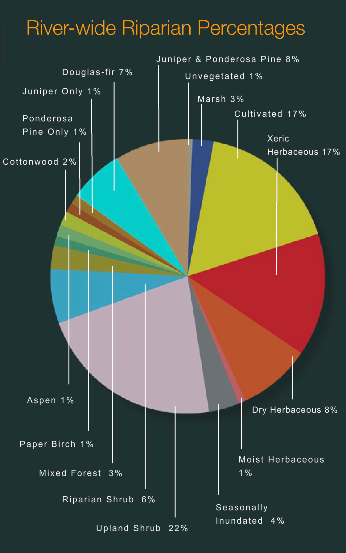
The first tab is a map of riparian vegetation types in Reach Two; the second shows a pie chart that displays the percentage of each of those types for the entire length of the river (all 72 miles).

Vegetation Type Descriptions
Click a type to learn more
- Juniper-only Forests
- Douglas-fir
- Juniper & Ponderosa Pine
- Ponderosa Pine Forests
- Paper Birch
- Riparian Shrub Communities
- Upland Shrub Communities
- Dry Herbaceous Communities
- Xeric Herbaceous Communities
- Black Cottonwood Forests
- Cultivated Land
- Marsh Communities
- Seasonally Inundated Mudflats and Gravel Bars
- Mixed Forest Communities
- Fire Occurence

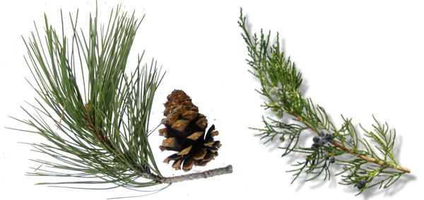
Juniper-Only Forests
Salish: Punɫp
Kootenai: ʾakuk̓pⱡuⱡaⱡ
These forests, which make up about 1% of the river's riparian zone, often contain ponderosa pine.
Juniper varies from a bushy shrub to a tree 50-feet tall. The trunk is short and stout. The crown is generally dense, although the branches may become long, slender and drooping.
The wood has been used for lance shafts and bows, and the needles burned ceremonially. Tea can be made from the boughs and branches to treat colds.

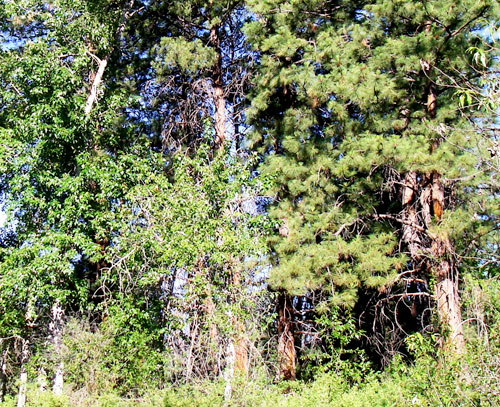
Douglas-fir Forests
Salish: Cq̓ɫp
Kootenai: Ⱡu
Douglas-fir forests make up about 7% of the riparian zone. These forests often contain some ponderosa pine and Rocky Mountain juniper as well.
Douglas-fir is really not a fir at all. Many things about it are different than the true firs, especially the cones. Because of fire exclusion, this tree has greatly expanded its distribution. Shrubs in the understory include snowberry, Wood's rose, service-berry, Oregon-grape, ninebark, and ocean spray. Forbs include dandelion, common yarrow, spotted knapweed, and wild strawberry.

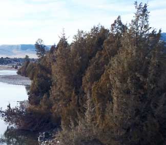
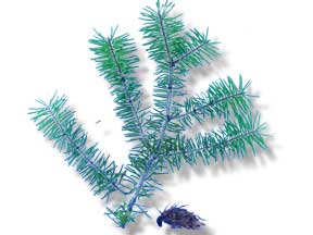
Juniper and Ponderosa Pine Forests
Salish: Punɫp / Sʔátq͏ʷɫp
Kootenai: ʾakukpⱡuⱡaⱡ / Himu
These two trees are found together throughout the river corridor, especially below Goose Bend. This type of vegetation makes up about 8% of the riparian zone.

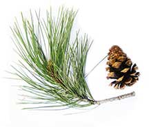
Ponderosa Pine Forests
Salish: Sʔátq͏ʷɫp
Kootenai: Himu
Ponderosa pine, pure stands of which occupy about 1% of the river corridor's riparian zone, is the state tree of Montana. It is a very important tree for lumber, growing from 50 to 180 feet tall. On the river it is found by itself, but it also grows with black cotton-wood and juniper and dense shrubs, including red-osier dogwood, serviceberry, and Wood's rose.
It has three needles or sometimes two in each bundle and they are usually 4-7 inches long in tufts at the end of the branches. The cones are 3-6 inches long, broadly rounded at base, tapered to the tip, short and squat; bright green, becoming reddish brown as they get older and armed with small spines. The bark is dark on small trees, cinnamon-brown to orange-yellow, thick and broken into large, flat, irregular “jig-saw puzzle-shaped” plates on old trees.

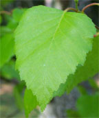
Paper Birch
Paper birch, which occupies about 1% of the river corridor's riparian zone, grows 60 to 80 feet tall and cannot tolerate shade. It takes over areas after fires and was used in the past to make canoes and baskets.
The leaves are oval or ovate, 2-5 inches long and 1-2 inches wide, usually rounded at the base with the margins toothed. They are dark green and shiny above, yellow-green below.
The bark is creamy white, separating into thin, papery layers, and marked by long, narrow, horizontal, dark, corky lines. The inner bark is orange.

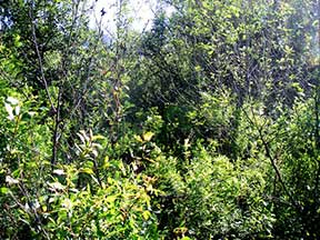
Riparian Shrub Communities
Riparian shrub communities, which occupy about 6% of the riparian zone in the river corridor, are often found near the high water mark along the river.
They most often include sandbar willow, red-osier dogwood, Douglas hawthorn, Wood's rose, western snowberry and Bebb's willow. Willow and dogwood are often found together, and rose is frequently found with hawthorne, dogwood, and snowberry.
Grasses frequently found include redtop bentgrass, reed canarygrass, fowl bluegrass, Kentucky bluegrass, and quackgrass.
Other plants in this community include Canada thistle, hemp dogbane, black medic, Canada goldenrod, loosestrife and poison ivy.

Upland Shrub Communities
Upland shrub communities, which occupy about 22% of the riparian zone in the river corridor, can be found both near the high water mark and a considerable distance inland and above the high water mark.
Shrubs found in upland communities include big sagebrush, rubber rabbitbrush, antelope bitterbrush, oceanspray, and serviceberry.
Bluebunch wheatgrass, cheatgrass, prairie junegrass (Koeleria cristata) and Kentucky bluegrass are the most common grasses, and fringed sagebrush, arrowleaf balsamroot, spotted knapweed, and mullein are the most common forbs.

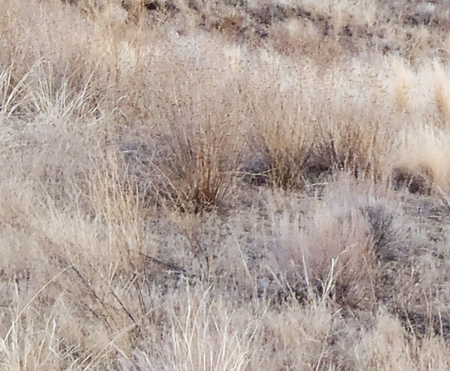
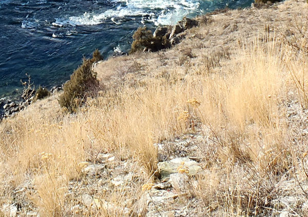
Dry Herbaceous Communities
Dry herbaceous communities, which occupy about 8% of the river corridor, are often found on steep slopes and rocky banks adjacent to the river. Many of these sites are adjacent to the riparian zone; few are contained within it.
The community includes three types of subcommunities: western wheatgrass with Idaho fescue; bluebunch wheatgrass with rough fescue; and Kentucky bluegrass with quackgrass (this last one is found on disturbed sites). Redtop bentgrass and Canada thistle are found on many of these sites, as is spotted knapweed, common timothy, baltic rush, and prickly lettuce.
Xeric Herbaceous Communities
Xeric means extremely dry, and xeric herbaceous communities are the driest on the river. They are usually found farther from the riparian zone or are on especially fine and dry soils. The dominant species in this community are needle-and-thread grass with red threeawn grass, spotted knapweed, erect cinquefoil, and sand dropseed. Cheatgrass, fringed sagebrush, goatweed, and Kentucky bluegrass are also common.
Many of these species have been introduced, and some are troublesome weeds. Fringed sagebrush is an indicator of intensive cattle grazing, Many of these communities are obviously impacted by grazing and some appear to have been heavily grazed in the 1930's and never allowed to recover. These areas are not significantly impacted by water levels, but are used by geese because of their forage value and proximity to the river.
Black Cottonwood Forest
Salish: Mulš
Kootenai: Kanuⱡ mamaⱡ aqpiʾk
Black cottonwood forests occupy about 2% of the riparian zone of the river corridor. The tree grows up to 120 feet high. It is the largest of our cottonwoods. When mature, its trunk is often free of branches up to one-half its height. It has broad, oval-shaped crowns when grown in open sites. It grows on moist soils along streams and rivers. The leaves are 3-7 inches long and 3-4 inches wide; broad, rounded at base. The bark is smooth and greenish on young stems; becomes gray and sharply furrowed, 1 to 2 inches thick as the tree ages.
Because of the way Kerr Dam was operated for many decades (major reductions in peak flows and rapidly fluctuating water levels), there has generally been a tremendous loss of species like black cottonwood and sandbar willow, which pioneer flooded areas like gravel bars. At the same time species ponderosa pine and Rocky Mountain juniper have expanded.

Cultivated Land
Cultivated land includes pasture lands (lands grazed annually by livestock, alfalfa, grainfields, and lawns. By curtailing peak flows, Kerr Dam has "dewatered" much of the floodplain, and that has led to a tremendous conversion of the riparian vegetation to agricultural land. In addition. many of the wetter shrub types have been changed to herbaceous vegetation because of overgrazing of the riparian zone,
Marsh Communities
Marsh communities on the river can be classified as tall and short. Tall marshes are made up of common cattail, flowering rush, hardstem bulrush, and reed canarygrass. Dominant species in the short marsh include water horsetail, common spikerush, arrowroot, beaked sedge, marestail and a combination of jointed rush and slender spikerush.
Marsh communities are vulnerable to water level fluctuations, yet are critical feeding sites for numerous shorebirds and fish, as well as geese in the late spring.
It is likely that the diversity of marsh habitat was greater on the river before regulation of water levels.
Seasonally Inundated Mudflats and Gravel Bars
Gravel bars and mudflats are found throughout the river corridor. Because of the fluctuating water levels (in spring they are underwater and in fall they are exposed), these areas are, for the most part, unvegetated. Still they provide important habitat for shorebirds and waterfowl.

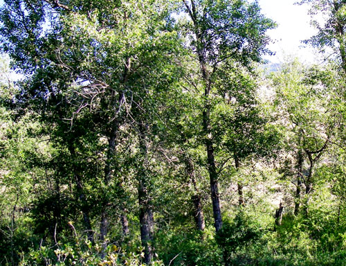
Mixed Forest Communities
Mixed forests are highly variable in the species they have, but birch and Douglas fir are common together, sometimes with black cottonwood, aspen, and/or Rocky Mountain maple as well. Black cottonwood and ponderosa pine are also frequently found together.
Because of the different species present, these forests are used by many wildlife species and have among the highest diversity of bird life.
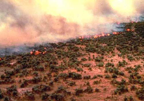
Fire Occurrence
Areas within the Flathead River Corridor burned on average about once every 8.5 years prior to the days of fire suppression (the average was 8.5 years but actual fire frequency ranged between 5 to 25 years). Some of those fires were lit by Indian people to clear campsites and improve forage for horses and wildlife. The fires generally did not kill large, mature trees. They were brief, low intensity fires that burned mostly grass and shrubs.
It is difficult to control wildfires within the river corridor because the roads are poor and parts of the corridor don't have any roads. Fuels include grasses and native shrubs (sage and bitterbrush), and open stands of ponderosa pine and juniper. There are lots of important natural and cultural resources along the river, many of which benefit from frequent fires. Prescribed fire is the best way to assure protection and restoration of those resources.
On this page you can explore River Reach Two, which runs from Buffalo Bridge to a point ten miles downstream. The river drops about 3.2 feet/mile and averages just over 400 feet wide. Throughout this reach the river gradually widens, but it maintains a single channel. With the exception of a few small islands and constrictions of the river channel, the flow is a smooth glide. The river makes several large, meandering bends which are bordered by high, eroding clay cliffs. River banks are generally steep with benchlands beyond; the channel substrate ranges from solid bedrock to sizeable areas of silt deposition.

Reach Two
Buffalo Bridge to a Point Ten Miles Downstream of the Bridge

Click a Map Pin
Off-Road Vehicle Use
Spoiling the Beauty
Driving off road is not cool. Tally the damage and you realize just how uncool it is. It damages soils, compacting them, making them less permeable to water and drying them out, making it more difficult for plants to live. It increases erosion, increasing sediment production and destroying fish habitat. It kills vegetation, crushing plants and seedlings. In arid environments like the river corridor, vegetation is more susceptible because plants in dry environments grow slowly and many have shallow root systems. It dramatically reduces the diversity of plant species and increases weeds. Wildlife suffers. And it ruins the beauty of the river corridor. No one likes to look at eroded hillsides and gullies caused by irresponsible people driving off roads. Plus it is illegal. People who drive off roads can receive significant fines and citations. Can you think of other problems that off road driving causes?

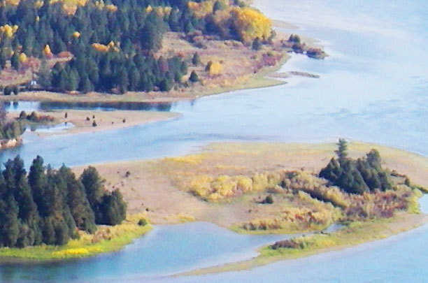
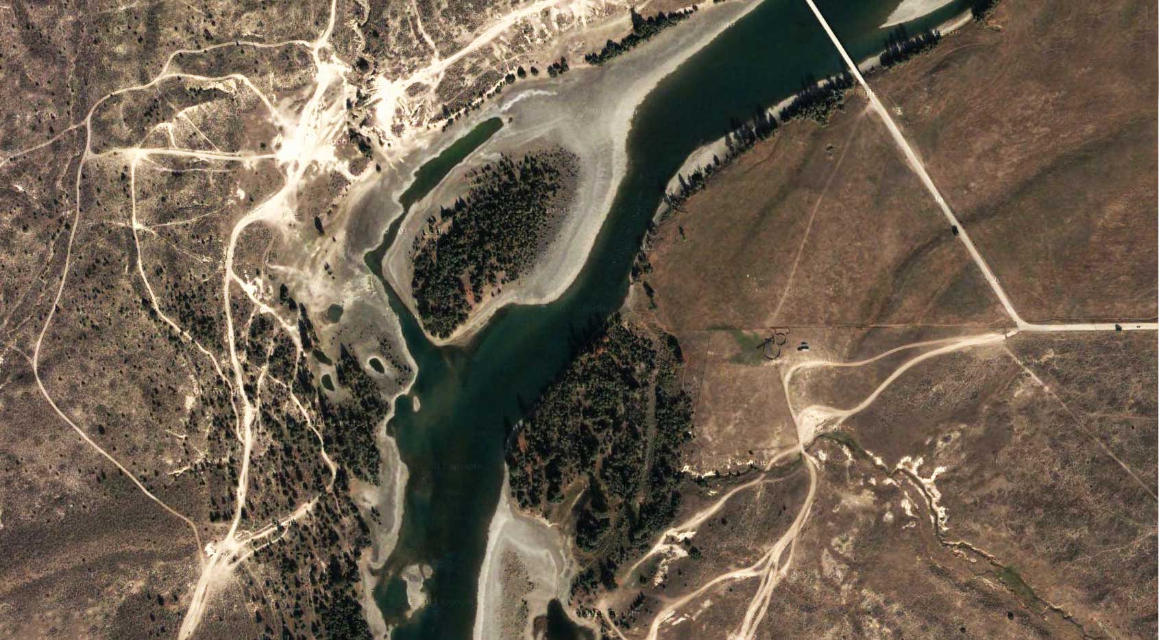
What's Beneath the River and Floodplain
If you could pull up a 1000-foot deep slice of the rocks and sediments under the river, it would look like the slice shown below, which is based mostly on descriptions from the water-well drillers who have drilled wells in the area and who keep logs or diaries about the materials they drill through. This slice is just north of Goose Bend.


Canada Geese

Different subspecies of Canada geese weigh from 3 pounds to 11 pounds. The large-bodied subspecies are mainly continental in distribution. Small-bodied ones breed in coastal Alaska and the Arctic. The subspecies of Canada Geese are listed below.
Large-Bodied Canada Geese
- default_titleAtlantic Canada Geese (Branta canadensis canadensis)
- default_titleHudson Bay or Interior Canada Geese (B. c. interior)
- default_titleGiant Canada Geese (B. c. maxima)
- default_titleWestern or Great Basin Canada Geese (B. c. moffitti)
- default_titleVancouver Canada Geese (B. c. fulva)
- default_titleDusky Canada Geese (B. c. occidentalis)
- Show More
Small-Bodied Canada Geese
- default_titleBaffin Island Canada Geese (Branta canadensis hutchinsii)
- default_titleTaverner’ s or Alaskan Canada Geese (B. c. taverneri)
- default_titleCackling Canada Geese (B. c. minima)
- default_titleAleutian Canada Geese (B. c. leucopareia)
- default_titleLesser or Athabasca Canada Geese (B. c. parvipes)
- Show More
Longnose Suckers

Longnose suckers can be identified by their snout, which is long, their lateral line, which has 95 to 120 scales, their lower lip, which is much wider than high, and their scales, which tend to be small and crowded toward the front.

Discussion Question:
Suckers are an important link in the food chain. They eat both algae and insects that live on the bottom of the river and they themselves are eaten by eagles, osprey, bull trout, and northern pike. The fry or young fish are also an important prey species for fish like northern pikeminnows. When they spawn, they are eaten by bears. They have also been harvested by people—their flesh is firm, white, flaky, and tastes good, though nowadays people seldom fish for them. What do you think would be the consequences if longnose suckers suddenly disappeared from the river?
Decision Point:
If you were the fisheries manager for the river, would you manage for all species of native fish or just the ones anglers like to catch? Why?
Managing Fires the Traditional Way
- Indian-lit Fires and the River
- The One Who Makes Fire
- Reasons for Burning
- Interview with Tony Incashola
Indian-lit Fires and the River
Most of the ancient ponderosas they have studied date to the 1500s, 1600s, or 1700s; a few of the very oldest of the trees began growing in the 1300s and 1400s. Across western Montana in ponderosa forests (and western larch and whitebark pine forest), the rings of the oldest trees show signs of fires at average intervals of between 5 and 25 years, depending on the forest type and elevation. In most places, these fires were far too frequent to have been caused by lightning; the tree rings are direct evidence of Indian use of fire.
This means that for many centuries tribal people set frequent fires along the river and in other places they lived and camped. These fires were not “stand-replacement” fires (fires that killed all the trees in a given area). The old trees survive to this day because the Indian fires were low-intensity fires that did not kill mature ponderosa pine trees, but did remove the brushy undergrowth that, if not removed could threaten them later. The big trees were the result of frequent fires, many of which were set by Indian people.
Discussion Question:
The cross section from a ponderosa pine stump at right reveals old fire scars that show an average fire frequency of one fire every 8.5 years. What do you think the consequences of removing fire (not just wildfires but also Indian-lit fires) from the river corridor is?
Decision Point:
If you were the fire manager for the area, what would you do to improve the situation?

Flows on the Lower Flathead River
River flows can vary dramatically from year to year. The graph below shows that between 1908 and 1937 there was a maximum flow one year that went above 80,000 cubic feet per second. During another year in that period, flows did not go over 20,000 cubic feet per second. So, depending on weather (how much rain and snow the basin receives and what the temperatures are) the river's flows can vary dramatically.
Discussion Question:
River flows affect all kinds of things. They are probably the biggest factor in shaping the river—moving gravel bars, cutting new channels, digging deep pools, etc. They also have an enormous affect on vegetation and fish and wildlife populations. Some species benefit from the scouring that floods cause, for example. What impacts do you think a dam has on river flows? Will a dam make flows more or less stable? What do you think would happen if Se̓liš Ksanka Qĺispe̓ Dam stopped all high flows on the river?
Decision Point:
If you were the manager of Se̓liš Ksanka Qĺispe̓ Dam, what kind of hydrograph would you try to manage for?

What's a Hydrograph
A hydrograph shows the amount of water flowing in a stream over a period of time. One cubic foot per second (cfs) is equal to one cubic foot of water flowing by every second, a rate equivalent to about 7.48 gallons per second. The data for a hydrograph comes from a stream gauge. To read a hydrographic, pick a date and move up to where it intersects the graph. Then read horizontally to the left to the discharge of the stream for that date (click on the graph below for an example of how to read a hydrograph.
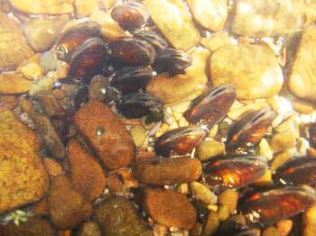
Western Pearlshell Mussels

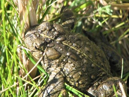
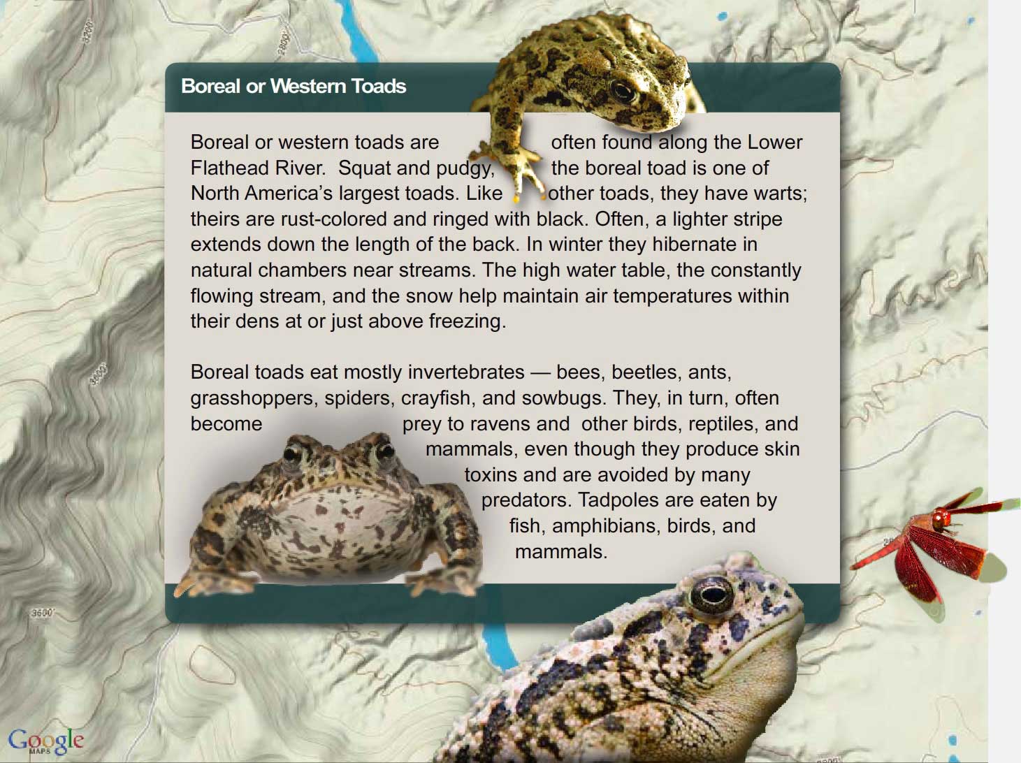
Boreal or Western Toads

Decision Point:
If you were the wildlife biologist in charge of managing wildlife in the river corridor, how would you go about determining the best measures to help boreal toads along the river? Can anything be done?

Glacial Lake Missoula Sediments

Decision Point:
If you were a land manager of lower Flathead River corridor, what steps would you take to protect vegetation and reduce unnatural erosion?

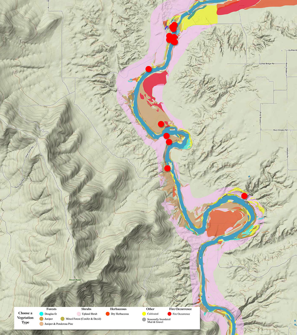
Riparian Vegetation
The term riparian vegetation refers to the plant habitats and communities along the river margins and its banks. Riparian zones are important because so many birds and mammals in western Montana depend on them.
The first tab is a map of riparian vegetation types in Reach Two; the second shows a pie chart that displays the percentage of each of those types for the entire length of the river (all 72 miles).

Vegetation Type Descriptions
Click a type to learn more
- Juniper-only Forests
- Douglas-fir
- Juniper & Ponderosa Pine
- Ponderosa Pine Forests
- Paper Birch
- Riparian Shrub Communities
- Upland Shrub Communities
- Dry Herbaceous Communities
- Xeric Herbaceous Communities
- Black Cottonwood Forests
- Cultivated Land
- Marsh Communities
- Seasonally Inundated Mudflats and Gravel Bars
- Mixed Forest Communities
- Fire Occurence
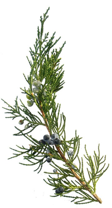
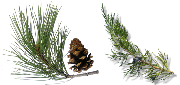
Juniper-Only Forests
Salish: Punɫp
Kootenai: ʾakuk̓pⱡuⱡaⱡ
These forests, which make up about 1% of the river's riparian zone, often contain ponderosa pine.
Juniper varies from a bushy shrub to a tree 50-feet tall. The trunk is short and stout. The crown is generally dense, although the branches may become long, slender and drooping.
The wood has been used for lance shafts and bows, and the needles burned ceremonially. Tea can be made from the boughs and branches to treat colds.


Douglas-fir Forests
Salish: Cq̓ɫp
Kootenai: Ⱡu
Douglas-fir forests make up about 7% of the riparian zone. These forests often contain some ponderosa pine and Rocky Mountain juniper as well.
Douglas-fir is really not a fir at all. Many things about it are different than the true firs, especially the cones. Because of fire exclusion, this tree has greatly expanded its distribution. Shrubs in the understory include snowberry, Wood's rose, service-berry, Oregon-grape, ninebark, and ocean spray. Forbs include dandelion, common yarrow, spotted knapweed, and wild strawberry.
Juniper and Ponderosa Pine Forests
Salish: Punɫp / Sʔátq͏ʷɫp
Kootenai: ʾakukpⱡuⱡaⱡ / Himu
These two trees are found together throughout the river corridor, especially below Goose Bend. This type of vegetation makes up about 8% of the riparian zone.


Ponderosa Pine Forests
Salish: Sʔátq͏ʷɫp
Kootenai: Himu
Ponderosa pine, pure stands of which occupy about 1% of the river corridor's riparian zone, is the state tree of Montana. It is a very important tree for lumber, growing from 50 to 180 feet tall. On the river it is found by itself, but it also grows with black cotton-wood and juniper and dense shrubs, including red-osier dogwood, serviceberry, and Wood's rose.
It has three needles or sometimes two in each bundle and they are usually 4-7 inches long in tufts at the end of the branches. The cones are 3-6 inches long, broadly rounded at base, tapered to the tip, short and squat; bright green, becoming reddish brown as they get older and armed with small spines. The bark is dark on small trees, cinnamon-brown to orange-yellow, thick and broken into large, flat, irregular “jig-saw puzzle-shaped” plates on old trees.

Paper Birch
Paper birch, which occupies about 1% of the river corridor's riparian zone, grows 60 to 80 feet tall and cannot tolerate shade. It takes over areas after fires and was used in the past to make canoes and baskets.
The leaves are oval or ovate, 2-5 inches long and 1-2 inches wide, usually rounded at the base with the margins toothed. They are dark green and shiny above, yellow-green below.
The bark is creamy white, separating into thin, papery layers, and marked by long, narrow, horizontal, dark, corky lines. The inner bark is orange.

Riparian Shrub Communities
Riparian shrub communities, which occupy about 6% of the riparian zone in the river corridor, are often found near the high water mark along the river.
They most often include sandbar willow, red-osier dogwood, Douglas hawthorn, Wood's rose, western snowberry and Bebb's willow. Willow and dogwood are often found together, and rose is frequently found with hawthorne, dogwood, and snowberry.
Grasses frequently found include redtop bentgrass, reed canarygrass, fowl bluegrass, Kentucky bluegrass, and quackgrass.
Other plants in this community include Canada thistle, hemp dogbane, black medic, Canada goldenrod, loosestrife and poison ivy.

Upland Shrub Communities
Upland shrub communities, which occupy about 22% of the riparian zone in the river corridor, can be found both near the high water mark and a considerable distance inland and above the high water mark.
Shrubs found in upland communities include big sagebrush, rubber rabbitbrush, antelope bitterbrush, oceanspray, and serviceberry.
Bluebunch wheatgrass, cheatgrass, prairie junegrass (Koeleria cristata) and Kentucky bluegrass are the most common grasses, and fringed sagebrush, arrowleaf balsamroot, spotted knapweed, and mullein are the most common forbs.
Dry Herbaceous Communities
Dry herbaceous communities, which occupy about 8% of the river corridor, are often found on steep slopes and rocky banks adjacent to the river. Many of these sites are adjacent to the riparian zone; few are contained within it.
The community includes three types of subcommunities: western wheatgrass with Idaho fescue; bluebunch wheatgrass with rough fescue; and Kentucky bluegrass with quackgrass (this last one is found on disturbed sites). Redtop bentgrass and Canada thistle are found on many of these sites, as is spotted knapweed, common timothy, baltic rush, and prickly lettuce.

Xeric Herbaceous Communities
Xeric means extremely dry, and xeric herbaceous communities are the driest on the river. They are usually found farther from the riparian zone or are on especially fine and dry soils. The dominant species in this community are needle-and-thread grass with red threeawn grass, spotted knapweed, erect cinquefoil, and sand dropseed. Cheatgrass, fringed sagebrush, goatweed, and Kentucky bluegrass are also common.
Many of these species have been introduced, and some are troublesome weeds. Fringed sagebrush is an indicator of intensive cattle grazing, Many of these communities are obviously impacted by grazing and some appear to have been heavily grazed in the 1930's and never allowed to recover. These areas are not significantly impacted by water levels, but are used by geese because of their forage value and proximity to the river.

Black Cottonwood Forest
Salish: Mulš
Kootenai: Kanuⱡ mamaⱡ aqpiʾk
Black cottonwood forests occupy about 2% of the riparian zone of the river corridor. The tree grows up to 120 feet high. It is the largest of our cottonwoods. When mature, its trunk is often free of branches up to one-half its height. It has broad, oval-shaped crowns when grown in open sites. It grows on moist soils along streams and rivers. The leaves are 3-7 inches long and 3-4 inches wide; broad, rounded at base. The bark is smooth and greenish on young stems; becomes gray and sharply furrowed, 1 to 2 inches thick as the tree ages.
Because of the way Kerr Dam was operated for many decades (major reductions in peak flows and rapidly fluctuating water levels), there has generally been a tremendous loss of species like black cottonwood and sandbar willow, which pioneer flooded areas like gravel bars. At the same time species ponderosa pine and Rocky Mountain juniper have expanded.

Cultivated Land
Cultivated land includes pasture lands (lands grazed annually by livestock, alfalfa, grainfields, and lawns. By curtailing peak flows, Kerr Dam has "dewatered" much of the floodplain, and that has led to a tremendous conversion of the riparian vegetation to agricultural land. In addition. many of the wetter shrub types have been changed to herbaceous vegetation because of overgrazing of the riparian zone,

Marsh Communities
Marsh communities on the river can be classified as tall and short. Tall marshes are made up of common cattail, flowering rush, hardstem bulrush, and reed canarygrass. Dominant species in the short marsh include water horsetail, common spikerush, arrowroot, beaked sedge, marestail and a combination of jointed rush and slender spikerush.
Marsh communities are vulnerable to water level fluctuations, yet are critical feeding sites for numerous shorebirds and fish, as well as geese in the late spring.
It is likely that the diversity of marsh habitat was greater on the river before regulation of water levels.

Seasonally Inundated Mudflats and Gravel Bars
Gravel bars and mudflats are found throughout the river corridor. Because of the fluctuating water levels (in spring they are underwater and in fall they are exposed), these areas are, for the most part, unvegetated. Still they provide important habitat for shorebirds and waterfowl.
Mixed Forest Communities
Mixed forests are highly variable in the species they have, but birch and Douglas fir are common together, sometimes with black cottonwood, aspen, and/or Rocky Mountain maple as well. Black cottonwood and ponderosa pine are also frequently found together.
Because of the different species present, these forests are used by many wildlife species and have among the highest diversity of bird life.

Fire Occurrence
Areas within the Flathead River Corridor burned on average about once every 8.5 years prior to the days of fire suppression (the average was 8.5 years but actual fire frequency ranged between 5 to 25 years). Some of those fires were lit by Indian people to clear campsites and improve forage for horses and wildlife. The fires generally did not kill large, mature trees. They were brief, low intensity fires that burned mostly grass and shrubs.
It is difficult to control wildfires within the river corridor because the roads are poor and parts of the corridor don't have any roads. Fuels include grasses and native shrubs (sage and bitterbrush), and open stands of ponderosa pine and juniper. There are lots of important natural and cultural resources along the river, many of which benefit from frequent fires. Prescribed fire is the best way to assure protection and restoration of those resources.

Reach Two
On this page you can explore River Reach Two, which runs from Buffalo Bridge to a point ten miles downstream. The river drops about 3.2 feet/mile and averages just over 400 feet wide. Throughout this reach the river gradually widens, but it maintains a single channel. With the exception of a few small islands and constrictions of the river channel, the flow is a smooth glide. The river makes several large, meandering bends which are bordered by high, eroding clay cliffs. River banks are generally steep with benchlands beyond; the channel substrate ranges from solid bedrock to sizeable areas of silt deposition.
Reach Two
Buffalo Bridge to a Point Ten Miles Downstream of the Bridge

Click a Map Pin
Off-Road Vehicle Use
Spoiling the Beauty
Driving off road is not cool. Tally the damage and you realize just how uncool it is. It damages soils, compacting them, making them less permeable to water and drying them out, making it more difficult for plants to live. It increases erosion, increasing sediment production and destroying fish habitat. It kills vegetation, crushing plants and seedlings. In arid environments like the river corridor, vegetation is more susceptible because plants in dry environments grow slowly and many have shallow root systems. It dramatically reduces the diversity of plant species and increases weeds. Wildlife suffers. And it ruins the beauty of the river corridor. No one likes to look at eroded hillsides and gullies caused by irresponsible people driving off roads. Plus it is illegal. People who drive off roads can receive significant fines and citations. Can you think of other problems that off road driving causes?
What's Beneath the River and Floodplain
If you could pull up a 1000-foot deep slice of the rocks and sediments under the river, it would look like the slice shown below, which is based mostly on descriptions from the water-well drillers who have drilled wells in the area and who keep logs or diaries about the materials they drill through. This slice is just north of Goose Bend.


Canada Geese

Different subspecies of Canada geese weigh from 3 pounds to 11 pounds. The large-bodied subspecies are mainly continental in distribution. Small-bodied ones breed in coastal Alaska and the Arctic. The subspecies of Canada Geese are listed below.
Large-Bodied Canada Geese
- default_titleAtlantic Canada Geese (Branta canadensis canadensis)
- default_titleHudson Bay or Interior Canada Geese (B. c. interior)
- default_titleGiant Canada Geese (B. c. maxima)
- default_titleWestern or Great Basin Canada Geese (B. c. moffitti)
- default_titleVancouver Canada Geese (B. c. fulva)
- default_titleDusky Canada Geese (B. c. occidentalis)
- Show More
Small-Bodied Canada Geese
- default_titleBaffin Island Canada Geese (Branta canadensis hutchinsii)
- default_titleTaverner’ s or Alaskan Canada Geese (B. c. taverneri)
- default_titleCackling Canada Geese (B. c. minima)
- default_titleAleutian Canada Geese (B. c. leucopareia)
- default_titleLesser or Athabasca Canada Geese (B. c. parvipes)
- Show More
Longnose Suckers

Longnose suckers can be identified by their snout, which is long, their lateral line, which has 95 to 120 scales, their lower lip, which is much wider than high, and their scales, which tend to be small and crowded toward the front.

Discussion Question:
Suckers are an important link in the food chain. They eat both algae and insects that live on the bottom of the river and they themselves are eaten by eagles, osprey, bull trout, and northern pike. The fry or young fish are also an important prey species for fish like northern pikeminnows. When they spawn, they are eaten by bears. They have also been harvested by people—their flesh is firm, white, flaky, and tastes good, though nowadays people seldom fish for them. What do you think would be the consequences if longnose suckers suddenly disappeared from the river?
Decision Point:
If you were the fisheries manager for the river, would you manage for all species of native fish or just the ones anglers like to catch? Why?
Managing Fires the Traditional Way
- Indian-lit Fires and the River
- The One Who Makes Fire
- Reasons for Burning
- Interview with Tony Incashola
Indian-lit Fires and the River

Most of the ancient ponderosas they have studied date to the 1500s, 1600s, or 1700s; a few of the very oldest of the trees began growing in the 1300s and 1400s. Across western Montana in ponderosa forests (and western larch and whitebark pine forest), the rings of the oldest trees show signs of fires at average intervals of between 5 and 25 years, depending on the forest type and elevation. In most places, these fires were far too frequent to have been caused by lightning; the tree rings are direct evidence of Indian use of fire.
This means that for many centuries tribal people set frequent fires along the river and in other places they lived and camped. These fires were not “stand-replacement” fires (fires that killed all the trees in a given area). The old trees survive to this day because the Indian fires were low-intensity fires that did not kill mature ponderosa pine trees, but did remove the brushy undergrowth that, if not removed could threaten them later. The big trees were the result of frequent fires, many of which were set by Indian people.
Discussion Question:
The cross section from a ponderosa pine stump at right reveals old fire scars that show an average fire frequency of one fire every 8.5 years. What do you think the consequences of removing fire (not just wildfires but also Indian-lit fires) from the river corridor is?
Decision Point:
If you were the fire manager for the area, what would you do to improve the situation?


Flows on the Lower Flathead River
River flows can vary dramatically from year to year. The graph below shows that between 1908 and 1937 there was a maximum flow one year that went above 80,000 cubic feet per second. During another year in that period, flows did not go over 20,000 cubic feet per second. So, depending on weather (how much rain and snow the basin receives and what the temperatures are) the river's flows can vary dramatically.
Discussion Question:
River flows affect all kinds of things. They are probably the biggest factor in shaping the river—moving gravel bars, cutting new channels, digging deep pools, etc. They also have an enormous affect on vegetation and fish and wildlife populations. Some species benefit from the scouring that floods cause, for example. What impacts do you think a dam has on river flows? Will a dam make flows more or less stable? What do you think would happen if Se̓liš Ksanka Qĺispe̓ Dam stopped all high flows on the river?
Decision Point:
If you were the manager of Se̓liš Ksanka Qĺispe̓ Dam, what kind of hydrograph would you try to manage for?
What's a Hydrograph
A hydrograph shows the amount of water flowing in a stream over a period of time. One cubic foot per second (cfs) is equal to one cubic foot of water flowing by every second, a rate equivalent to about 7.48 gallons per second. The data for a hydrograph comes from a stream gauge. To read a hydrographic, pick a date and move up to where it intersects the graph. Then read horizontally to the left to the discharge of the stream for that date (click on the graph below for an example of how to read a hydrograph.
Western Pearlshell Mussels

Boreal or Western Toads

Decision Point:
If you were the wildlife biologist in charge of managing wildlife in the river corridor, how would you go about determining the best measures to help boreal toads along the river? Can anything be done?
Glacial Lake Missoula Sediments

Decision Point:
If you were a land manager of lower Flathead River corridor, what steps would you take to protect vegetation and reduce unnatural erosion?
Riparian Vegetation
The term riparian vegetation refers to the plant habitats and communities along the river margins and its banks. Riparian zones are important because so many birds and mammals in western Montana depend on them.
The first tab is a map of riparian vegetation types in Reach Two; the second shows a pie chart that displays the percentage of each of those types for the entire length of the river (all 72 miles).


Vegetation Type Descriptions
Click a type to learn more
- Juniper-only Forests
- Douglas-fir
- Juniper & Ponderosa Pine
- Ponderosa Pine Forests
- Paper Birch
- Riparian Shrub Communities
- Upland Shrub Communities
- Dry Herbaceous Communities
- Xeric Herbaceous Communities
- Black Cottonwood Forests
- Cultivated Land
- Marsh Communities
- Seasonally Inundated Mudflats and Gravel Bars
- Mixed Forest Communities
- Fire Occurence

Juniper-Only Forests
Salish: Punɫp
Kootenai: ʾakuk̓pⱡuⱡaⱡ
These forests, which make up about 1% of the river's riparian zone, often contain ponderosa pine.
Juniper varies from a bushy shrub to a tree 50-feet tall. The trunk is short and stout. The crown is generally dense, although the branches may become long, slender and drooping.
The wood has been used for lance shafts and bows, and the needles burned ceremonially. Tea can be made from the boughs and branches to treat colds.

Douglas-fir Forests
Salish: Cq̓ɫp
Kootenai: Ⱡu
Douglas-fir forests make up about 7% of the riparian zone. These forests often contain some ponderosa pine and Rocky Mountain juniper as well.
Douglas-fir is really not a fir at all. Many things about it are different than the true firs, especially the cones. Because of fire exclusion, this tree has greatly expanded its distribution. Shrubs in the understory include snowberry, Wood's rose, service-berry, Oregon-grape, ninebark, and ocean spray. Forbs include dandelion, common yarrow, spotted knapweed, and wild strawberry.


Juniper and Ponderosa Pine Forests
Salish: Punɫp / Sʔátq͏ʷɫp
Kootenai: ʾakukpⱡuⱡaⱡ / Himu
These two trees are found together throughout the river corridor, especially below Goose Bend. This type of vegetation makes up about 8% of the riparian zone.

Ponderosa Pine Forests
Salish: Sʔátq͏ʷɫp
Kootenai: Himu
Ponderosa pine, pure stands of which occupy about 1% of the river corridor's riparian zone, is the state tree of Montana. It is a very important tree for lumber, growing from 50 to 180 feet tall. On the river it is found by itself, but it also grows with black cotton-wood and juniper and dense shrubs, including red-osier dogwood, serviceberry, and Wood's rose.
It has three needles or sometimes two in each bundle and they are usually 4-7 inches long in tufts at the end of the branches. The cones are 3-6 inches long, broadly rounded at base, tapered to the tip, short and squat; bright green, becoming reddish brown as they get older and armed with small spines. The bark is dark on small trees, cinnamon-brown to orange-yellow, thick and broken into large, flat, irregular “jig-saw puzzle-shaped” plates on old trees.


Paper Birch
Paper birch, which occupies about 1% of the river corridor's riparian zone, grows 60 to 80 feet tall and cannot tolerate shade. It takes over areas after fires and was used in the past to make canoes and baskets.
The leaves are oval or ovate, 2-5 inches long and 1-2 inches wide, usually rounded at the base with the margins toothed. They are dark green and shiny above, yellow-green below.
The bark is creamy white, separating into thin, papery layers, and marked by long, narrow, horizontal, dark, corky lines. The inner bark is orange.

Riparian Shrub Communities
Riparian shrub communities, which occupy about 6% of the riparian zone in the river corridor, are often found near the high water mark along the river.
They most often include sandbar willow, red-osier dogwood, Douglas hawthorn, Wood's rose, western snowberry and Bebb's willow. Willow and dogwood are often found together, and rose is frequently found with hawthorne, dogwood, and snowberry.
Grasses frequently found include redtop bentgrass, reed canarygrass, fowl bluegrass, Kentucky bluegrass, and quackgrass.
Other plants in this community include Canada thistle, hemp dogbane, black medic, Canada goldenrod, loosestrife and poison ivy.
Upland Shrub Communities
Upland shrub communities, which occupy about 22% of the riparian zone in the river corridor, can be found both near the high water mark and a considerable distance inland and above the high water mark.
Shrubs found in upland communities include big sagebrush, rubber rabbitbrush, antelope bitterbrush, oceanspray, and serviceberry.
Bluebunch wheatgrass, cheatgrass, prairie junegrass (Koeleria cristata) and Kentucky bluegrass are the most common grasses, and fringed sagebrush, arrowleaf balsamroot, spotted knapweed, and mullein are the most common forbs.

Dry Herbaceous Communities
Dry herbaceous communities, which occupy about 8% of the river corridor, are often found on steep slopes and rocky banks adjacent to the river. Many of these sites are adjacent to the riparian zone; few are contained within it.
The community includes three types of subcommunities: western wheatgrass with Idaho fescue; bluebunch wheatgrass with rough fescue; and Kentucky bluegrass with quackgrass (this last one is found on disturbed sites). Redtop bentgrass and Canada thistle are found on many of these sites, as is spotted knapweed, common timothy, baltic rush, and prickly lettuce.

Xeric Herbaceous Communities
Xeric means extremely dry, and xeric herbaceous communities are the driest on the river. They are usually found farther from the riparian zone or are on especially fine and dry soils. The dominant species in this community are needle-and-thread grass with red threeawn grass, spotted knapweed, erect cinquefoil, and sand dropseed. Cheatgrass, fringed sagebrush, goatweed, and Kentucky bluegrass are also common.
Many of these species have been introduced, and some are troublesome weeds. Fringed sagebrush is an indicator of intensive cattle grazing, Many of these communities are obviously impacted by grazing and some appear to have been heavily grazed in the 1930's and never allowed to recover. These areas are not significantly impacted by water levels, but are used by geese because of their forage value and proximity to the river.

Black Cottonwood Forest
Salish: Mulš
Kootenai: Kanuⱡ mamaⱡ aqpiʾk
Black cottonwood forests occupy about 2% of the riparian zone of the river corridor. The tree grows up to 120 feet high. It is the largest of our cottonwoods. When mature, its trunk is often free of branches up to one-half its height. It has broad, oval-shaped crowns when grown in open sites. It grows on moist soils along streams and rivers. The leaves are 3-7 inches long and 3-4 inches wide; broad, rounded at base. The bark is smooth and greenish on young stems; becomes gray and sharply furrowed, 1 to 2 inches thick as the tree ages.
Because of the way Kerr Dam was operated for many decades (major reductions in peak flows and rapidly fluctuating water levels), there has generally been a tremendous loss of species like black cottonwood and sandbar willow, which pioneer flooded areas like gravel bars. At the same time species ponderosa pine and Rocky Mountain juniper have expanded.
Cultivated Land
Cultivated land includes pasture lands (lands grazed annually by livestock, alfalfa, grainfields, and lawns. By curtailing peak flows, Kerr Dam has "dewatered" much of the floodplain, and that has led to a tremendous conversion of the riparian vegetation to agricultural land. In addition. many of the wetter shrub types have been changed to herbaceous vegetation because of overgrazing of the riparian zone,

Marsh Communities
Marsh communities on the river can be classified as tall and short. Tall marshes are made up of common cattail, flowering rush, hardstem bulrush, and reed canarygrass. Dominant species in the short marsh include water horsetail, common spikerush, arrowroot, beaked sedge, marestail and a combination of jointed rush and slender spikerush.
Marsh communities are vulnerable to water level fluctuations, yet are critical feeding sites for numerous shorebirds and fish, as well as geese in the late spring.
It is likely that the diversity of marsh habitat was greater on the river before regulation of water levels.

Seasonally Inundated Mudflats and Gravel Bars
Gravel bars and mudflats are found throughout the river corridor. Because of the fluctuating water levels (in spring they are underwater and in fall they are exposed), these areas are, for the most part, unvegetated. Still they provide important habitat for shorebirds and waterfowl.

Mixed Forest Communities
Mixed forests are highly variable in the species they have, but birch and Douglas fir are common together, sometimes with black cottonwood, aspen, and/or Rocky Mountain maple as well. Black cottonwood and ponderosa pine are also frequently found together.
Because of the different species present, these forests are used by many wildlife species and have among the highest diversity of bird life.

Fire Occurrence
Areas within the Flathead River Corridor burned on average about once every 8.5 years prior to the days of fire suppression (the average was 8.5 years but actual fire frequency ranged between 5 to 25 years). Some of those fires were lit by Indian people to clear campsites and improve forage for horses and wildlife. The fires generally did not kill large, mature trees. They were brief, low intensity fires that burned mostly grass and shrubs.
It is difficult to control wildfires within the river corridor because the roads are poor and parts of the corridor don't have any roads. Fuels include grasses and native shrubs (sage and bitterbrush), and open stands of ponderosa pine and juniper. There are lots of important natural and cultural resources along the river, many of which benefit from frequent fires. Prescribed fire is the best way to assure protection and restoration of those resources.

© 2021 Confederated Salish and Kootenai Tribes | Contact Us
© 2021 Confederated Salish and Kootenai Tribes | Contact Us