

Loading . . .
Interactive Map of the Lower
Flathead River
Natural and Human History of the River
Interactive Map
The Natural and Human History of the
Lower Flathead River
Interactive Map
The Natural and Human History of the
Lower Flathead River
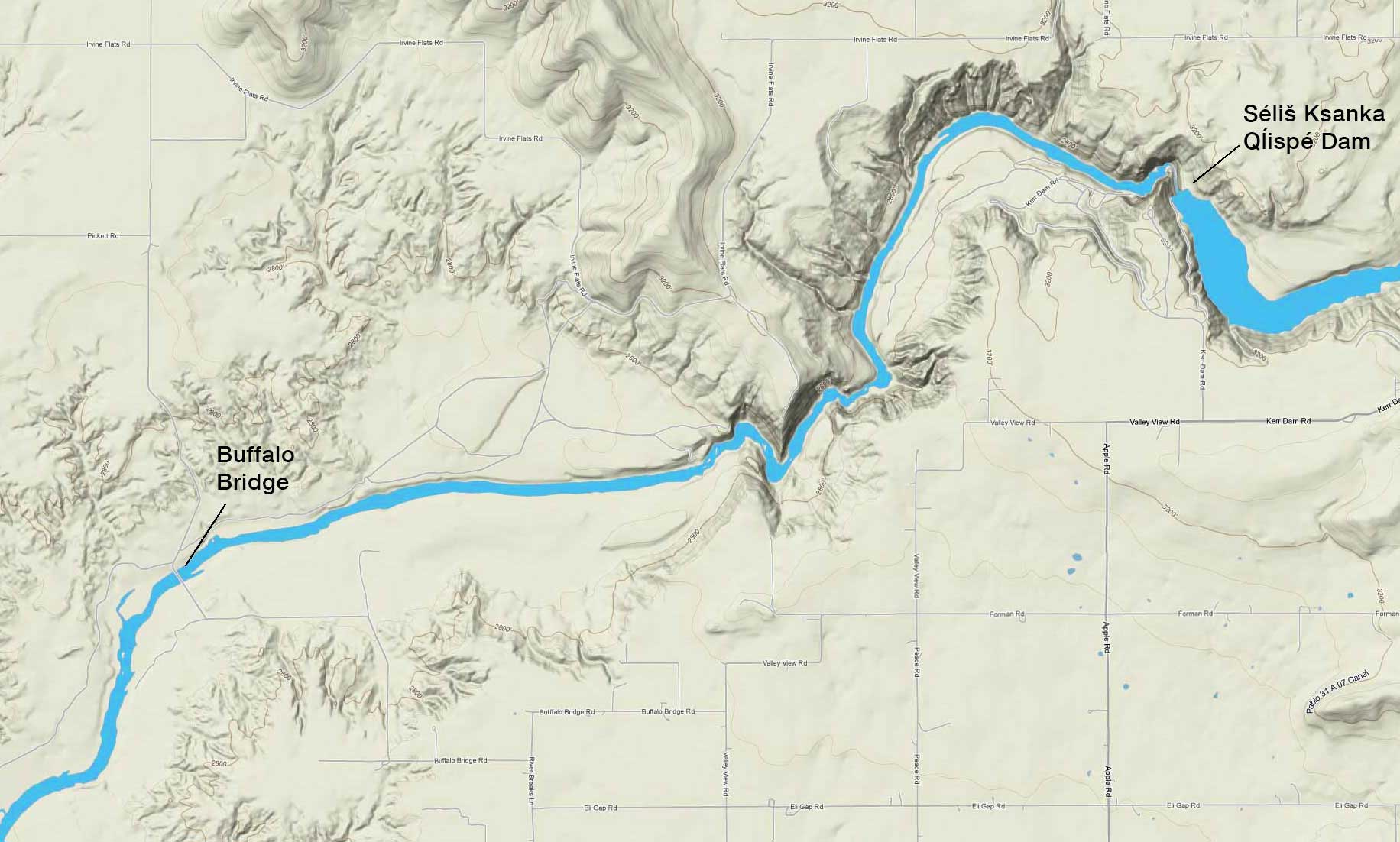
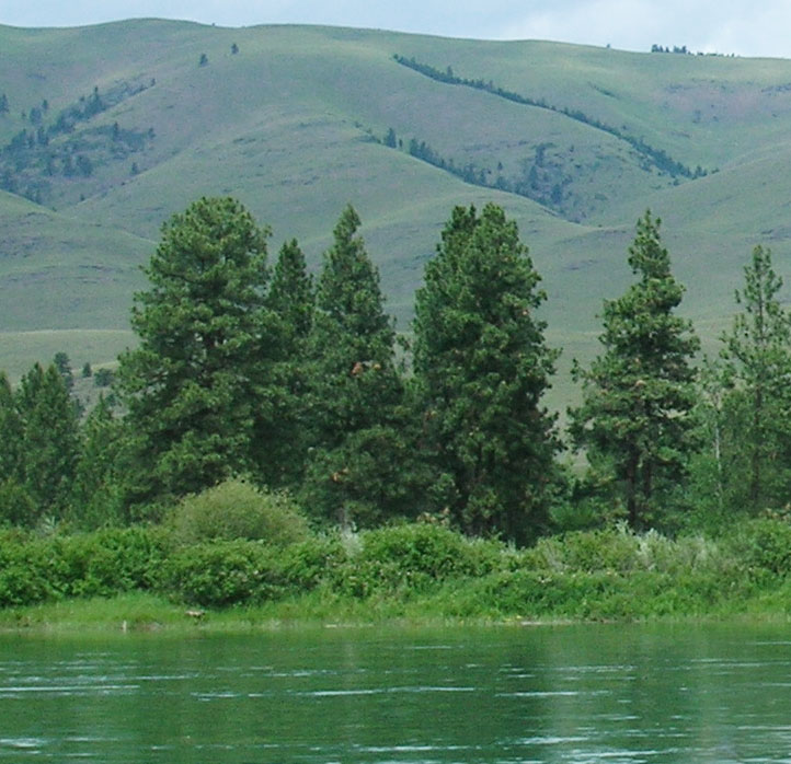
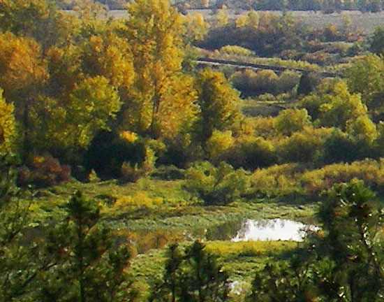
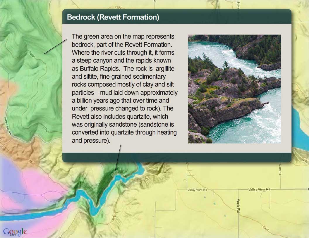
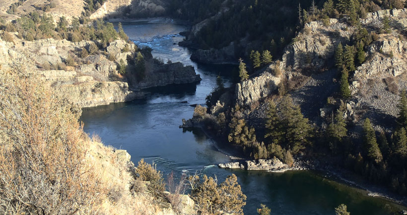
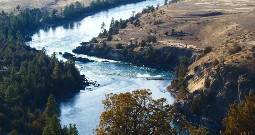
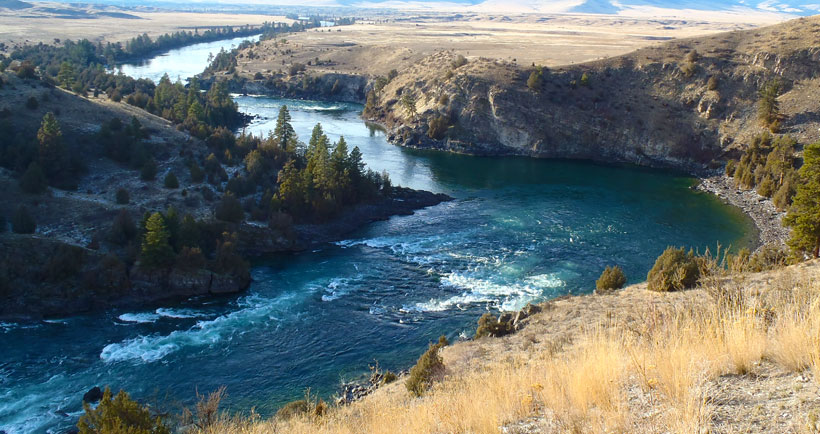
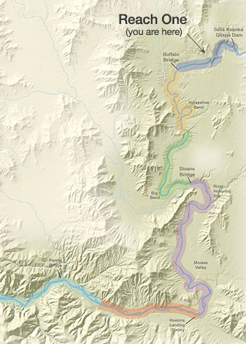
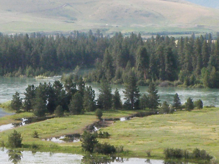
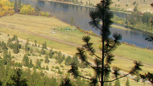
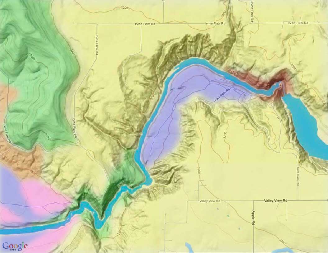
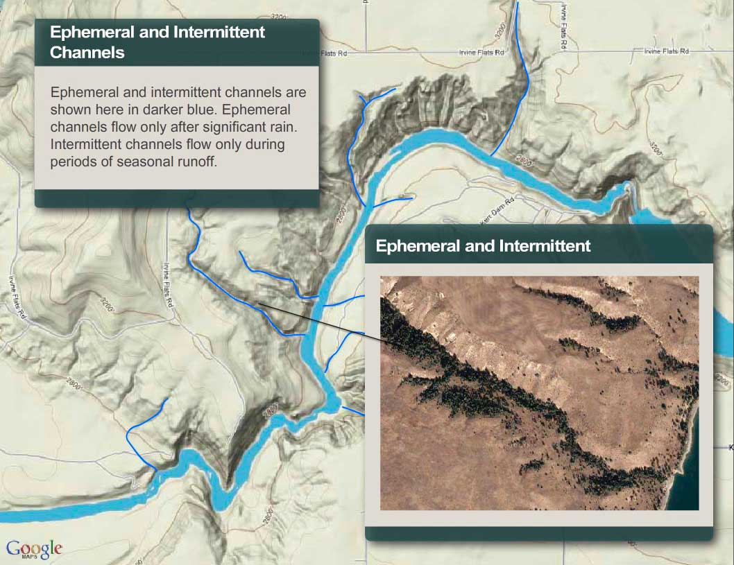
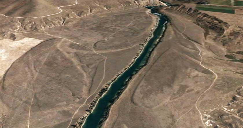
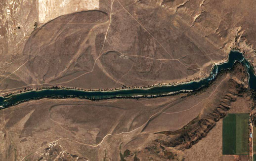
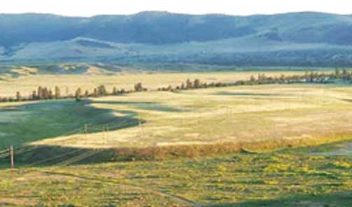
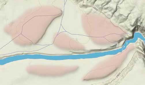
On this page you can start your journey in River Reach One, which runs from Se̓liš Ksanka Qĺispe̓ Dam to Buffalo Bridge. The river here averages 374 feet wide and has drops approximately 8 feet per mile. The first 3.7 miles are confined within a steep rocky canyon. In the canyon, the channel bottom is mostly a mixture of large-boulders and bedrock, and the river itself is characterized by deep pools and several sets of rapids. Outside of the canyon, the channel widens, and the bottom blends into a cobble-gravel veneer atop heavy clay. Here, the water moves in a smooth, fast flowing glide with two riffle areas. Use the map below to learn more about the geology, biology, and human history of the river by clicking on any of the map markers.
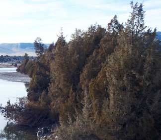
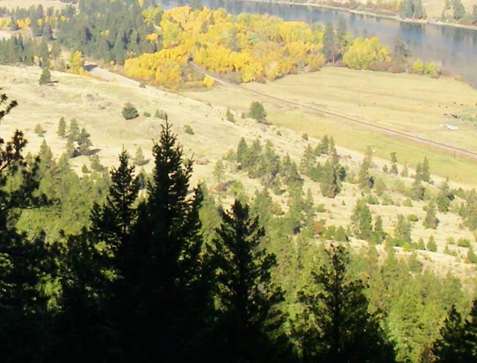
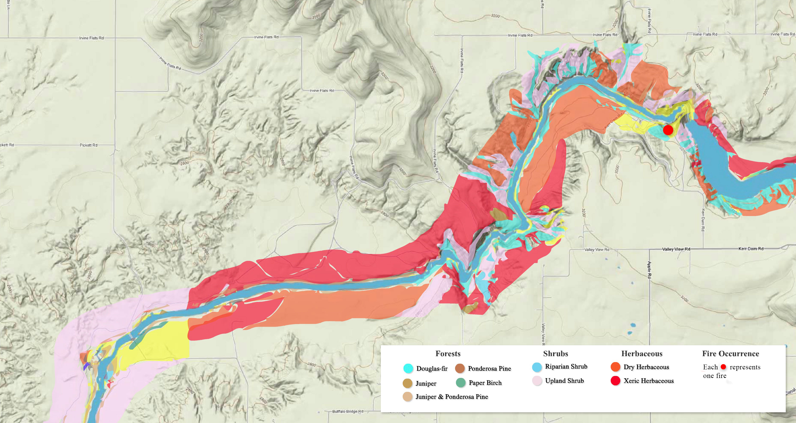
Riparian Vegetation
The term riparian vegetation refers to the plant habitats and communities along the river margins and its banks. Riparian zones are important because so many birds and mammals in western Montana depend on them.
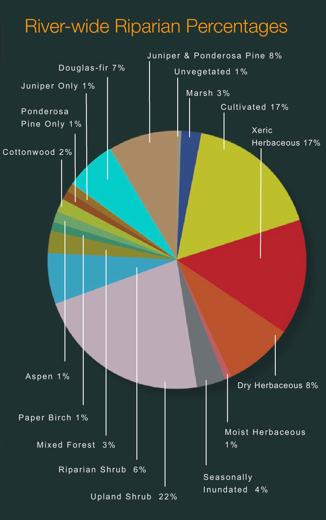
The first tab is a map of riparian vegetation types in Reach One; the second shows a pie chart that displays the percentage of each of those types for the entire length of the river (all 72 miles).

Vegetation Type Descriptions
Click a type to learn more
- Juniper-only Forests
- Douglas-fir
- Juniper & Ponderosa Pine
- Ponderosa Pine Forests
- Paper Birch
- Riparian Shrub Communities
- Upland Shrub Communities
- Dry Herbaceous Communities
- Xeric Herbaceous Communities
- Black Cottonwood Forests
- Cultivated Land
- Marsh Communities
- Seasonally Inundated Mudflats and Gravel Bars
- Mixed Forest Communities
- Fire Occurence

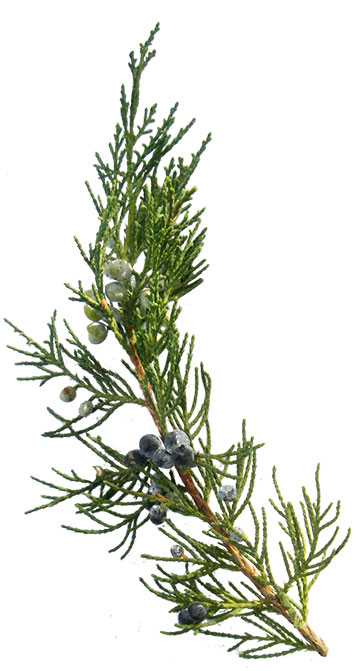
Juniper-Only Forests
Salish: Punɫp
Kootenai: ʾakuk̓pⱡuⱡaⱡ
These forests, which make up about 1% of the river's riparian zone, often contain ponderosa pine.
Juniper varies from a bushy shrub to a tree 50-feet tall. The trunk is short and stout. The crown is generally dense, although the branches may become long, slender and drooping.
The wood has been used for lance shafts and bows, and the needles burned ceremonially. Tea can be made from the boughs and branches to treat colds.

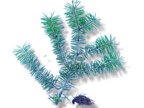
Douglas-fir Forests
Salish: Cq̓ɫp
Kootenai: Ⱡu
Douglas-fir forests make up about 7% of the riparian zone. These forests often contain some ponderosa pine and Rocky Mountain juniper as well.
Douglas-fir is really not a fir at all. Many things about it are different than the true firs, especially the cones. Because of fire exclusion, this tree has greatly expanded its distribution. Shrubs in the understory include snowberry, Wood's rose, service-berry, Oregon-grape, ninebark, and ocean spray. Forbs include dandelion, common yarrow, spotted knapweed, and wild strawberry.
Juniper and Ponderosa Pine Forests
Salish: Punɫp / Sʔátq͏ʷɫp
Kootenai: ʾakukpⱡuⱡaⱡ / Himu
These two trees are found together throughout the river corridor, especially below Goose Bend. This type of vegetation makes up about 8% of the riparian zone.


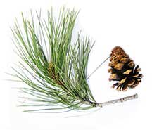
Ponderosa Pine Forests
Salish: Sʔátq͏ʷɫp
Kootenai: Himu
Ponderosa pine, pure stands of which occupy about 1% of the river corridor's riparian zone, is the state tree of Montana. It is a very important tree for lumber, growing from 50 to 180 feet tall. On the river it is found by itself, but it also grows with black cotton-wood and juniper and dense shrubs, including red-osier dogwood, serviceberry, and Wood's rose.
It has three needles or sometimes two in each bundle and they are usually 4-7 inches long in tufts at the end of the branches. The cones are 3-6 inches long, broadly rounded at base, tapered to the tip, short and squat; bright green, becoming reddish brown as they get older and armed with small spines. The bark is dark on small trees, cinnamon-brown to orange-yellow, thick and broken into large, flat, irregular “jig-saw puzzle-shaped” plates on old trees.
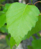
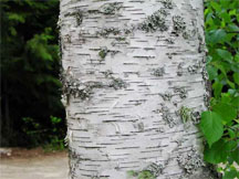
Paper Birch
Paper birch, which occupies about 1% of the river corridor's riparian zone, grows 60 to 80 feet tall and cannot tolerate shade. It takes over areas after fires and was used in the past to make canoes and baskets.
The leaves are oval or ovate, 2-5 inches long and 1-2 inches wide, usually rounded at the base with the margins toothed. They are dark green and shiny above, yellow-green below.
The bark is creamy white, separating into thin, papery layers, and marked by long, narrow, horizontal, dark, corky lines. The inner bark is orange.

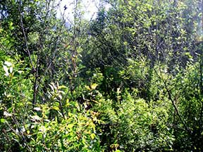
Riparian Shrub Communities
Riparian shrub communities, which occupy about 6% of the riparian zone in the river corridor, are often found near the high water mark along the river.
They most often include sandbar willow, red-osier dogwood, Douglas hawthorn, Wood's rose, western snowberry and Bebb's willow. Willow and dogwood are often found together, and rose is frequently found with hawthorne, dogwood, and snowberry.
Grasses frequently found include redtop bentgrass, reed canarygrass, fowl bluegrass, Kentucky bluegrass, and quackgrass.
Other plants in this community include Canada thistle, hemp dogbane, black medic, Canada goldenrod, loosestrife and poison ivy.

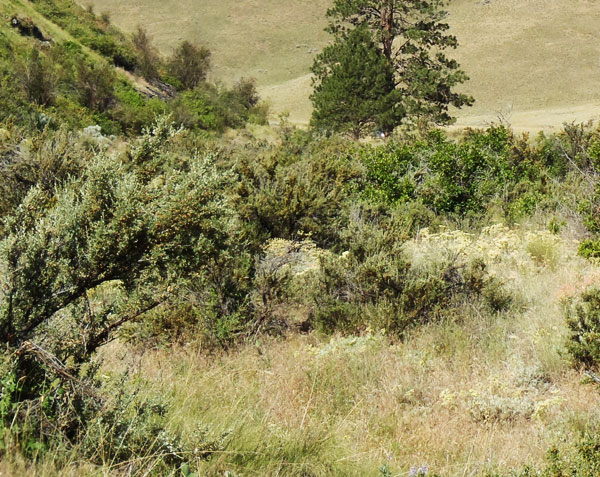
Upland Shrub Communities
Upland shrub communities, which occupy about 22% of the riparian zone in the river corridor, can be found both near the high water mark and a considerable distance inland and above the high water mark.
Shrubs found in upland communities include big sagebrush, rubber rabbitbrush, antelope bitterbrush, oceanspray, and serviceberry.
Bluebunch wheatgrass, cheatgrass, prairie junegrass (Koeleria cristata) and Kentucky bluegrass are the most common grasses, and fringed sagebrush, arrowleaf balsamroot, spotted knapweed, and mullein are the most common forbs.
Dry Herbaceous Communities
Dry herbaceous communities, which occupy about 8% of the river corridor, are often found on steep slopes and rocky banks adjacent to the river. Many of these sites are adjacent to the riparian zone; few are contained within it.
The community includes three types of subcommunities: western wheatgrass with Idaho fescue; bluebunch wheatgrass with rough fescue; and Kentucky bluegrass with quackgrass (this last one is found on disturbed sites). Redtop bentgrass and Canada thistle are found on many of these sites, as is spotted knapweed, common timothy, baltic rush, and prickly lettuce.

Xeric Herbaceous Communities
Xeric means extremely dry, and xeric herbaceous communities are the driest on the river. They are usually found farther from the riparian zone or are on especially fine and dry soils. The dominant species in this community are needle-and-thread grass with red threeawn grass, spotted knapweed, erect cinquefoil, and sand dropseed. Cheatgrass, fringed sagebrush, goatweed, and Kentucky bluegrass are also common.
Many of these species have been introduced, and some are troublesome weeds. Fringed sagebrush is an indicator of intensive cattle grazing, Many of these communities are obviously impacted by grazing and some appear to have been heavily grazed in the 1930's and never allowed to recover. These areas are not significantly impacted by water levels, but are used by geese because of their forage value and proximity to the river.

Black Cottonwood Forest
Salish: Mulš
Kootenai: Kanuⱡ mamaⱡ aqpiʾk
Black cottonwood forests occupy about 2% of the riparian zone of the river corridor. The tree grows up to 120 feet high. It is the largest of our cottonwoods. When mature, its trunk is often free of branches up to one-half its height. It has broad, oval-shaped crowns when grown in open sites. It grows on moist soils along streams and rivers. The leaves are 3-7 inches long and 3-4 inches wide; broad, rounded at base. The bark is smooth and greenish on young stems; becomes gray and sharply furrowed, 1 to 2 inches thick as the tree ages.
Because of the way Kerr Dam was operated for many decades (major reductions in peak flows and rapidly fluctuating water levels), there has generally been a tremendous loss of species like black cottonwood and sandbar willow, which pioneer flooded areas like gravel bars. At the same time species ponderosa pine and Rocky Mountain juniper have expanded.
Cultivated Land
Cultivated land includes pasture lands (lands grazed annually by livestock, alfalfa, grainfields, and lawns. By curtailing peak flows, Kerr Dam has "dewatered" much of the floodplain, and that has led to a tremendous conversion of the riparian vegetation to agricultural land. In addition. many of the wetter shrub types have been changed to herbaceous vegetation because of overgrazing of the riparian zone,

Marsh Communities
Marsh communities on the river can be classified as tall and short. Tall marshes are made up of common cattail, flowering rush, hardstem bulrush, and reed canarygrass. Dominant species in the short marsh include water horsetail, common spikerush, arrowroot, beaked sedge, marestail and a combination of jointed rush and slender spikerush.
Marsh communities are vulnerable to water level fluctuations, yet are critical feeding sites for numerous shorebirds and fish, as well as geese in the late spring.
It is likely that the diversity of marsh habitat was greater on the river before regulation of water levels.
Seasonally Inundated Mudflats and Gravel Bars
Gravel bars and mudflats are found throughout the river corridor. Because of the fluctuating water levels (in spring they are underwater and in fall they are exposed), these areas are, for the most part, unvegetated. Still they provide important habitat for shorebirds and waterfowl.

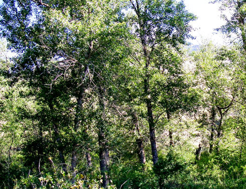
Mixed Forest Communities
Mixed forests are highly variable in the species they have, but birch and Douglas fir are common together, sometimes with black cottonwood, aspen, and/or Rocky Mountain maple as well. Black cottonwood and ponderosa pine are also frequently found together.
Because of the different species present, these forests are used by many wildlife species and have among the highest diversity of bird life.

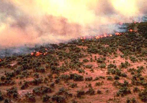
Fire Occurrence
Areas within the Flathead River Corridor burned on average about once every 8.5 years prior to the days of fire suppression (the average was 8.5 years but actual fire frequency ranged between 5 to 25 years). Some of those fires were lit by Indian people to clear campsites and improve forage for horses and wildlife. The fires generally did not kill large, mature trees. They were brief, low intensity fires that burned mostly grass and shrubs.
It is difficult to control wildfires within the river corridor because the roads are poor and parts of the corridor don't have any roads. Fuels include grasses and native shrubs (sage and bitterbrush), and open stands of ponderosa pine and juniper. There are lots of important natural and cultural resources along the river, many of which benefit from frequent fires. Prescribed fire is the best way to assure protection and restoration of those resources.

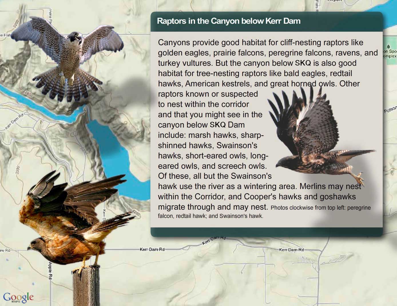
Raptors in the Canyon
Segment One Geomorphology
(geomorphology refers to the study of the physical features of the surface of the earth and their relation to its geological structures)
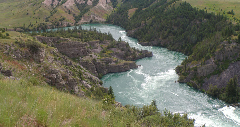
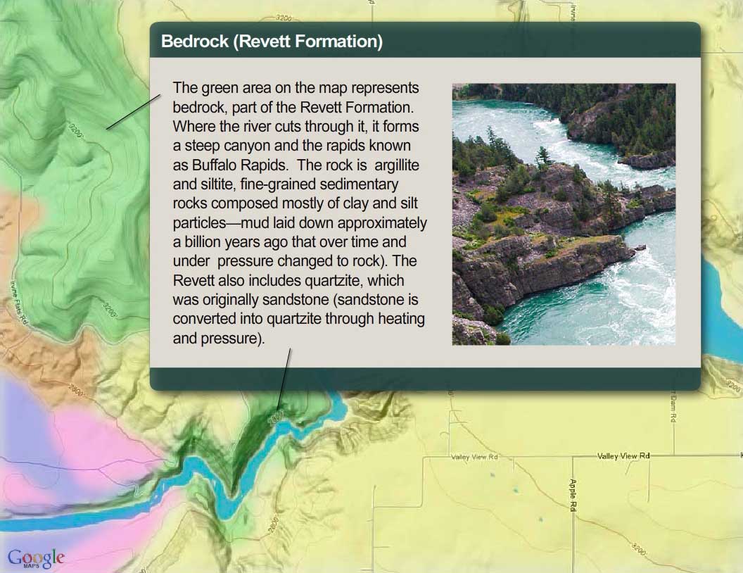
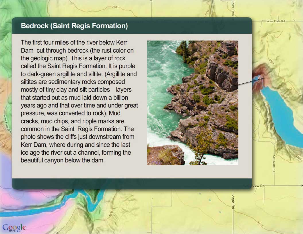
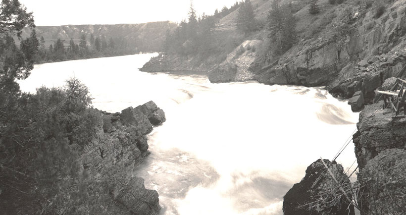
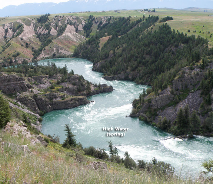
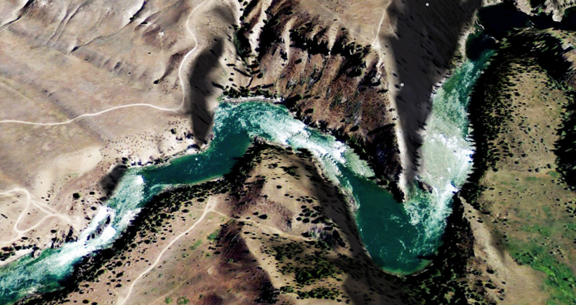
In the first part of this segment, the river flows through a canyon. In this canyon, the river bottom is made up of boulders and outcrops of bedrock. Beyond the canyon, the river cuts through silt-and-clay deposits laid down in Glacial Lake Missoula. There, the bottom is mostly cobbles and gravel resting on top of clay. From the dam to Buffalo Bridge, the river drops almost 8 feet per mile and averages 374 feet wide. The reach contains the only whitewater found on the river and the deepest pools.


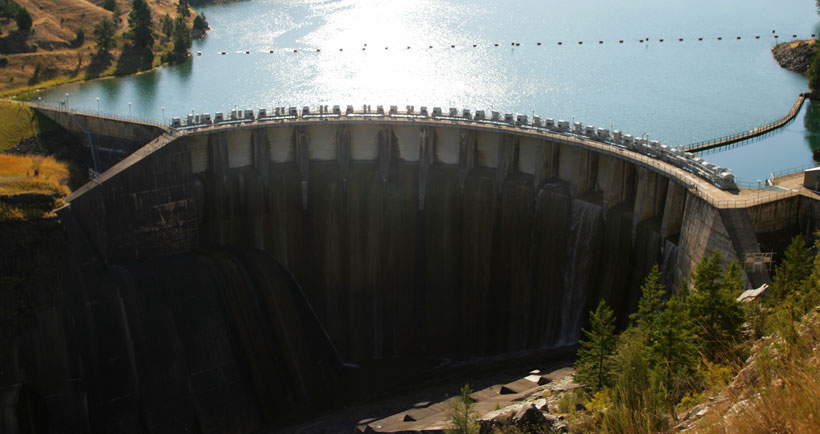
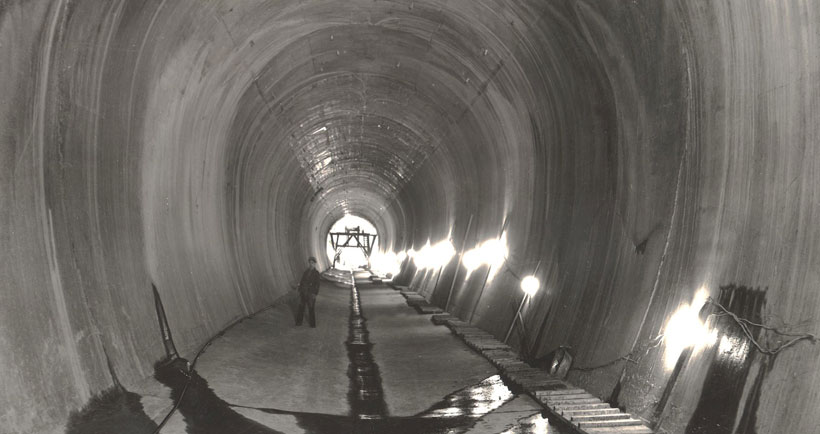
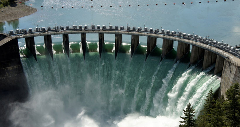
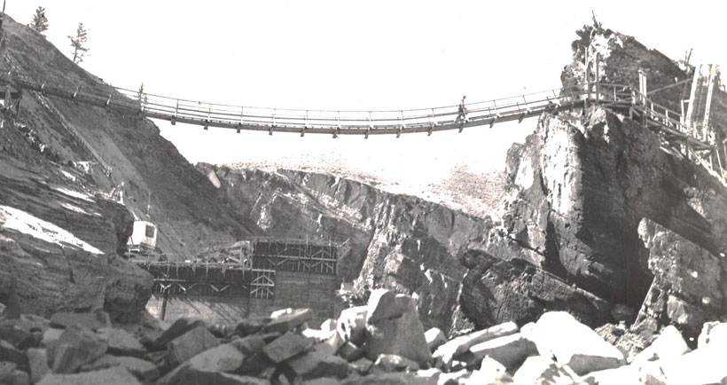
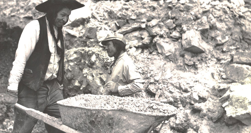
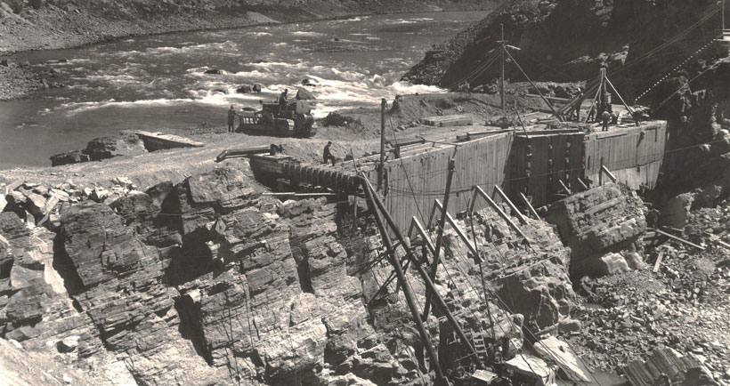
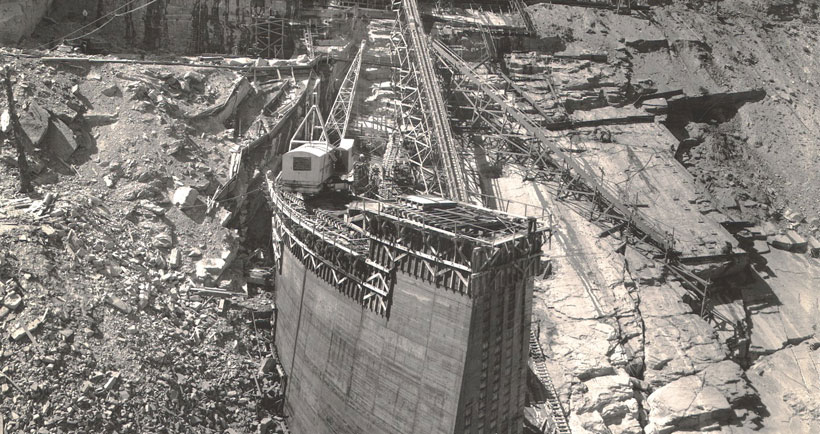
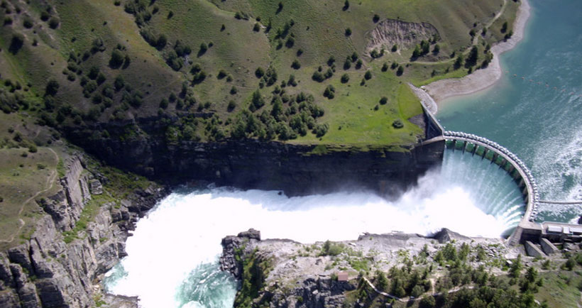
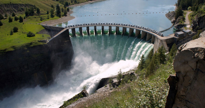
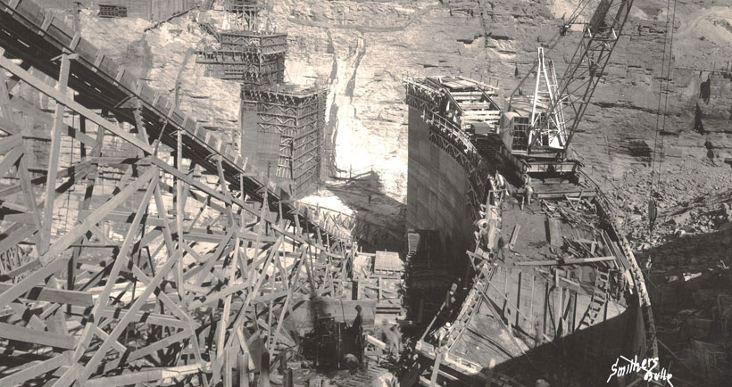
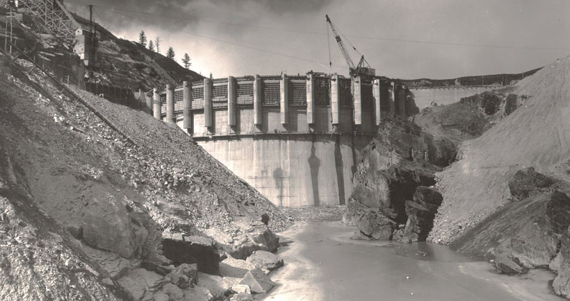
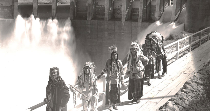
SéIiš Ksanka Ql̓ispé (SKQ) Dam
Brief Description
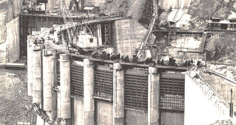
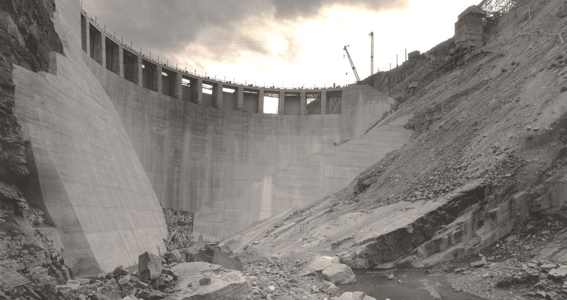
SKQ Dam is a three-generating-unit hydroelectric plant on the Flathead River about five miles southwest of Polson and the natural outlet of Flathead Lake. The units have a total generating capacity of 194 megawatts. One megawatt can satisfy the average energy needs of 750 households, so Kerr can supply enough energy to power 145,500 homes.
The dam, which began operation in 1938, is 541 feet long and 205 feet high. Its installation raised the level of Flathead Lake by 10 feet over the natural lake outlet. The dam’s 28-mile-long reservoir has a storage capacity of 1.2 million acre-feet. SKQ Dam is classified as a “storage generation” project because it uses the water stored in its reservoir to generate electricity.
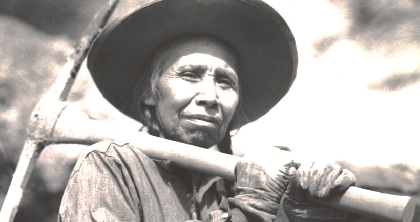
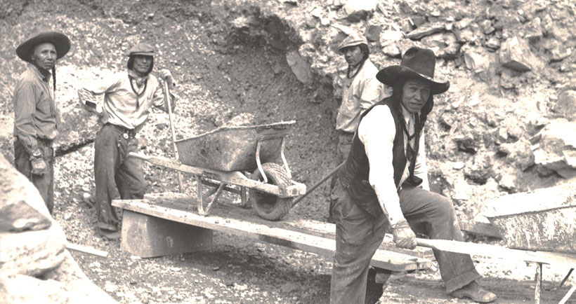
The dam is owned and operated by the Confederated Salish and Kootenai Tribes, which took control of the dam in 2015.
The Dam's Impacts
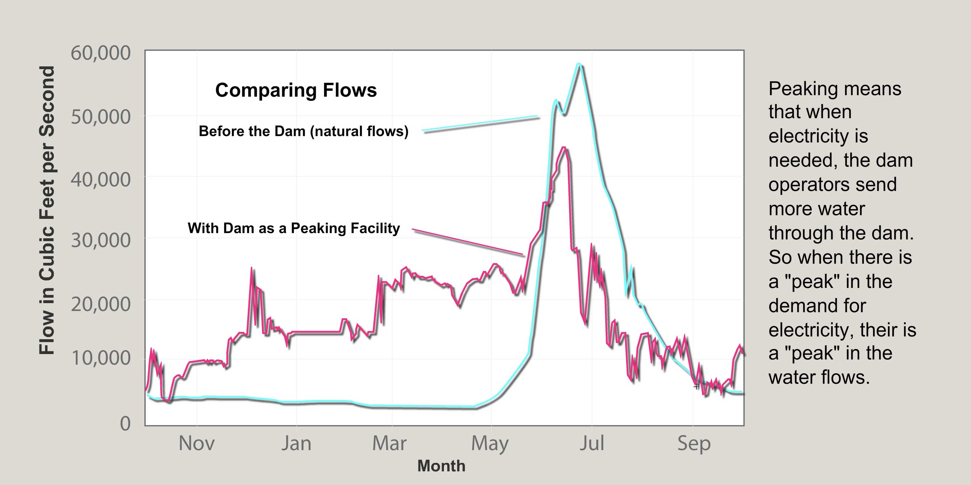
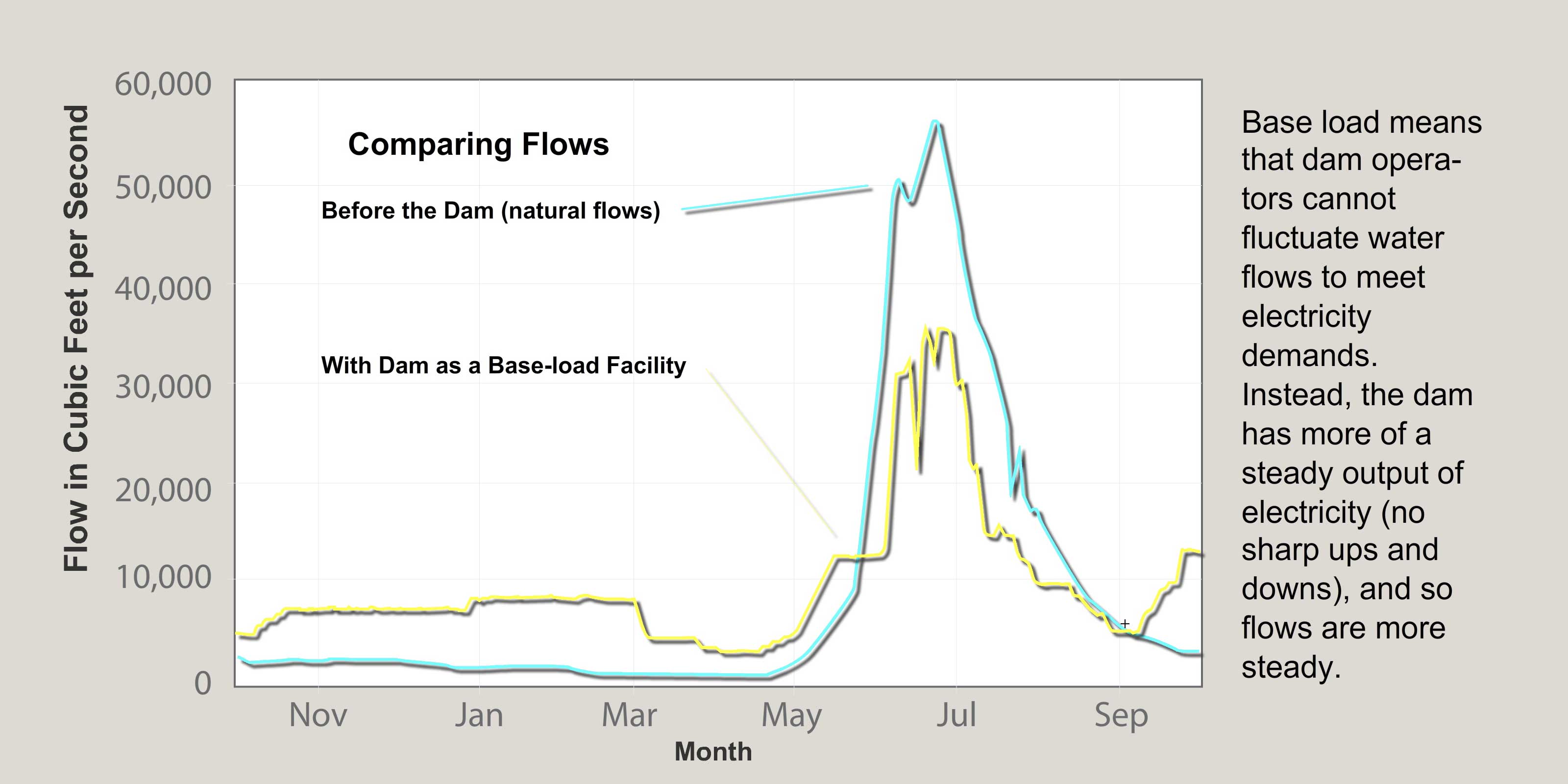
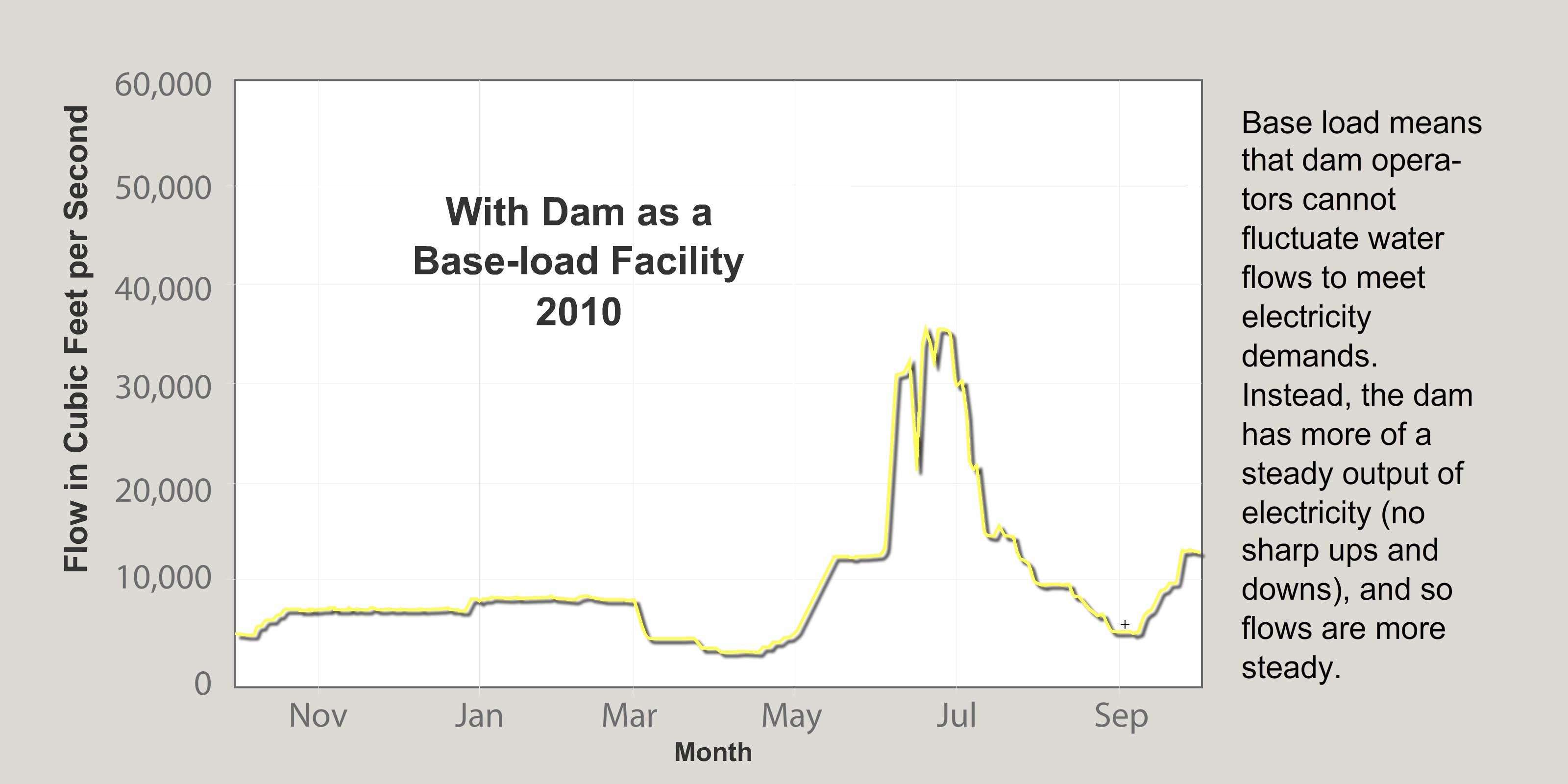
Water flows in the lower Flathead River are regulated by SKQ Dam and have been since the dam was completed in 1938. There is a stream gauge just below the dam that measures river flows over the course of a year. The hydrograph for the stream gauge shows the dam has reduced peak flows (flows in the spring) and increased winter flows.
These changes have caused the normally vegetated shoreline (what biologists call the varial zone) to become flooded in a way that would not occur with natural stream flows, and that does not allow riparian vegetation to exist where it normally would. This is especially true in the lower half of the river’s course. Many areas between the high and low water levels along this part of the river have become mostly unvegetated and instead are dominated by mud and rock.
Also, because the dam has for the most part ended flooding, it has shifted the species of trees growing along the river from deciduous species like cottonwood to conifers like ponderosa pine and juniper. Now conifers are the most common tree species found along the river.
In the past (from 1938 to the 1990s) the dam was operated so that flows fluctuated dramatically even over the course of a day. They were as unnatural as could be. Now the dam is operated so that flows are more natural, but still, floods are curtailed, and so the vegetation is not able to recover. It is still undergoing a long-term shift away from deciduous species and varial zones are not fully revegetated.


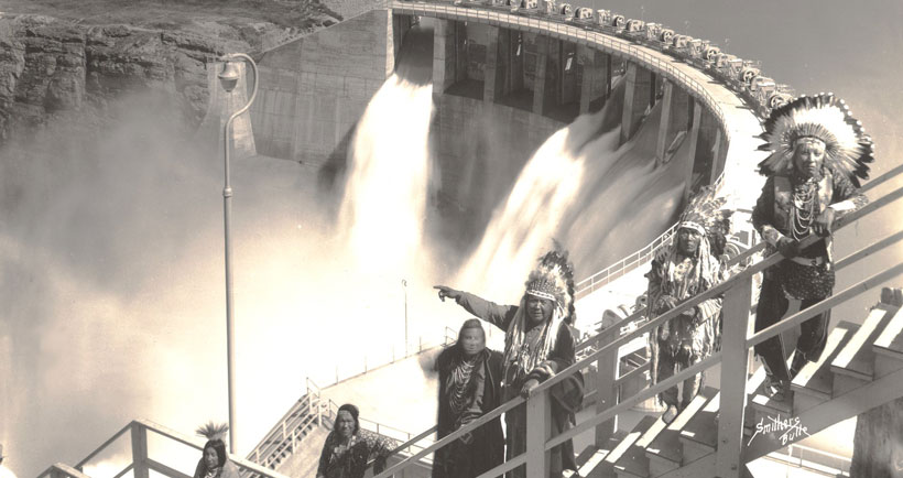

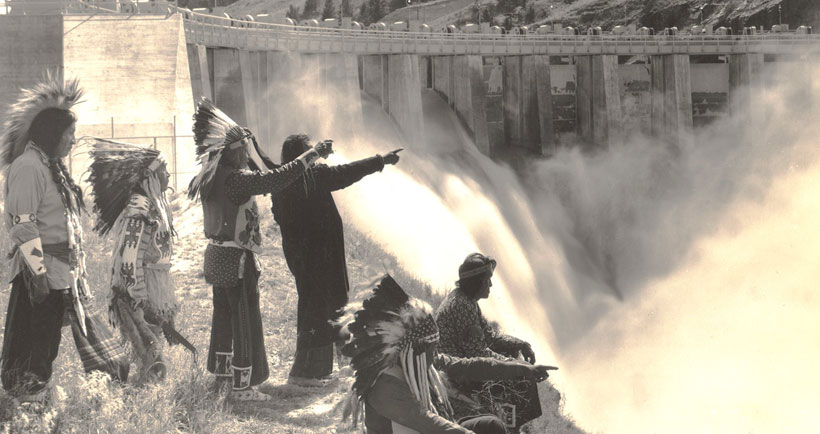
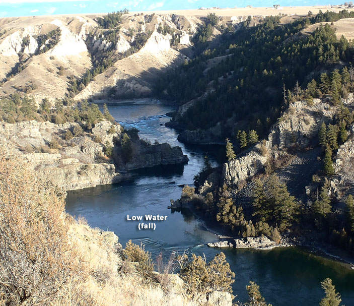
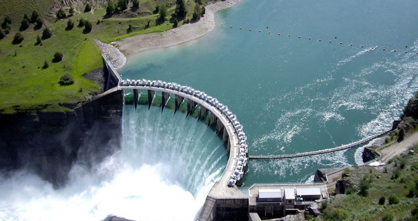
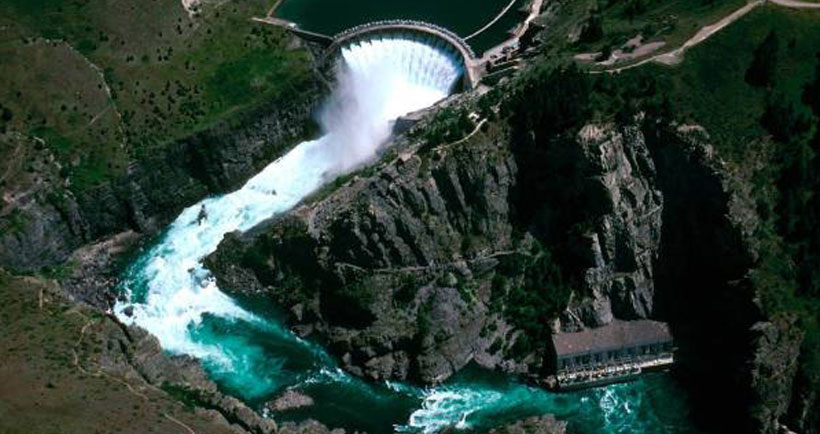
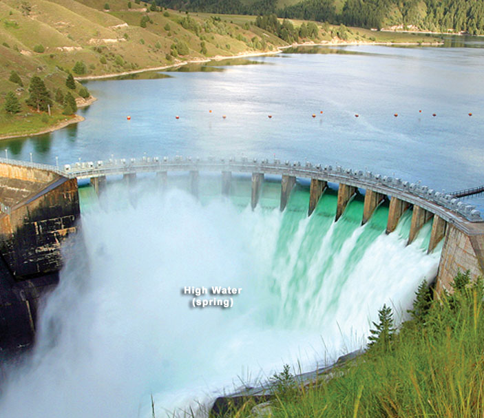
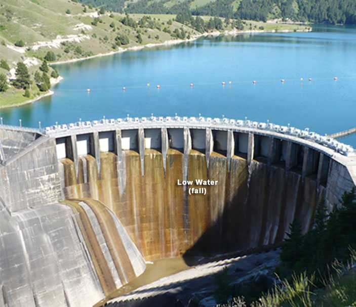
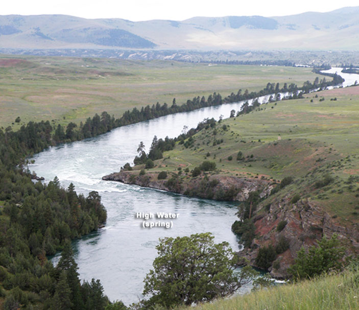
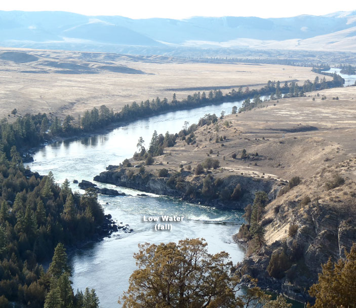
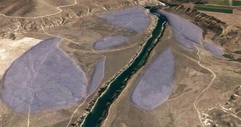
High and Low Water at Se̓liš Ksanka Qĺispe̓ (SKQ) Dam
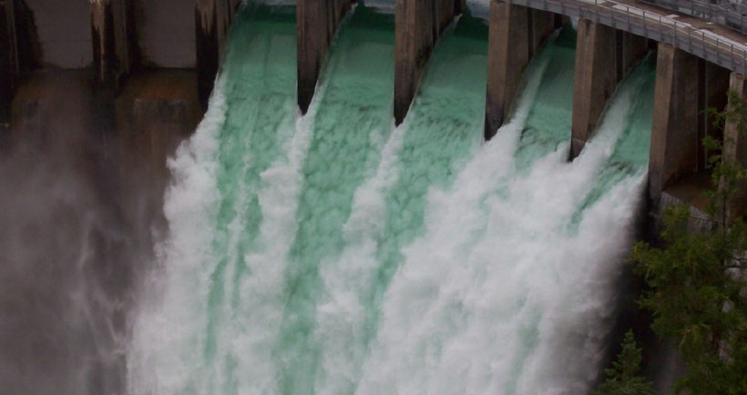
The two images below (use the slider to compare them) show the difference between spring and fall flows at SKQ Dam. When the water is high and the lake has been filled, dam managers open the gates at the top of the dam. The turbines too are running at capacity at this time. In the summer, the gates close and flows through the dam drop, lowering flows in the river below the dam.
Discussion Questions:
- default_titleWhy do dam managers make sure Flathead Lake is full in the spring?
- default_titleIs letting so much water out in the spring good or bad for fish and wildlife downstream?
- default_titleWho decides when to close the gates and what goes into their decision?
- default_titleAre low flows in late summer and fall harmful to fish and wildlife?
- Show More


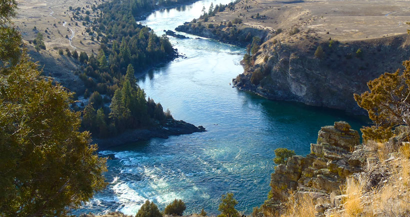
High and Low Water at Buffalo Rapids One & Two
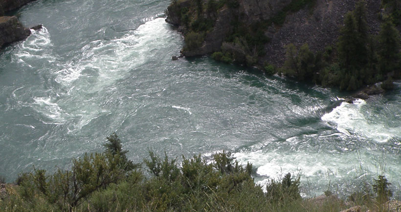
The first seven miles below the dam are called "Buffalo Rapids." The river, flowing through the steep terrain of the canyon drops 8 feet per mile, the steepest drop of the river. Depending on current stream flows, several class III and IV rapids1 with sizeable waves and holes can exist. Kayaking and rafting is popular along the Buffalo Rapids reach. This section of the river offers good whitewater and the big waves and holes. At flows above 20,000 cfs, many of the rapids wash out, though powerful currents and suctions can be hazardous. Also, this river stretch becomes more difficult at low to moderate flows when large waves and holes develop and some sharp drops and rocks appear.
______________
1 CLASS III: Rapids with moderate, irregular waves that may be difficult to avoid. Large waves and strainers may be present, but are easily avoided. Swimming injuries rare. Suitable for those who do not mind getting a little wet, otherwise, same as class I and II.
CLASS IV rapids are defined as Intense, powerful, but predictable rapids requiring precise boat handling in turbulent water. May feature large, unavoidable waves and holes or constricted passages demanding fast maneuvers under pressure. Risk of injury to swimmers moderate to high, and water conditions may make self-rescue difficult. Suitable for those 12 and older, in good physical condition. With experienced guides, this level is recommended for first-timers as well as those with prior experience.
Buffalo Rapids One

Buffalo Rapids Two


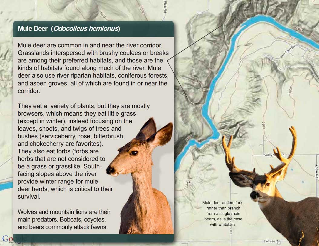
Mule Deer: Eating and Being Eaten

A mountain lion will kill a deer every four to fourteen days. Mule deer have developed a unique escape behavior to deal with predators like mountain lions. It is called stotting: when they sense danger, they flee using a stifflegged bound (called a stott), bringing all four feet off the ground at the same time. A mule deer uses the leaps to bound up slopes and over bushes and rocks, making it difficult for predators to follow.
One mountain lion eats 1,125 pounds of venison each year. How many deer are needed to feed one mountain lion for a year if the deer average 150 pounds in weight?
One mule deer eats approximately 3,650 pounds of vegetation each year. One square mile of mule deer habitat produces 760 pounds of deer food each year. How many square miles of habitat are needed to support one mule deer?


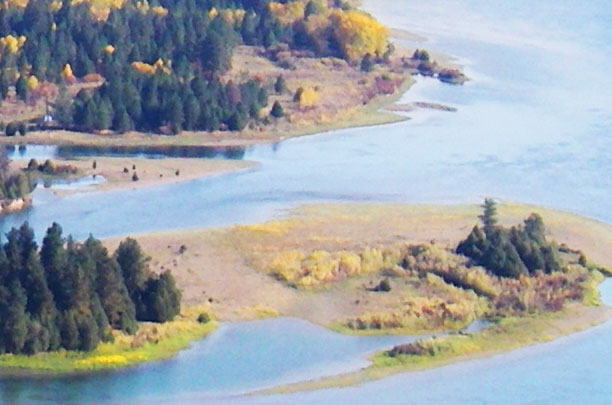
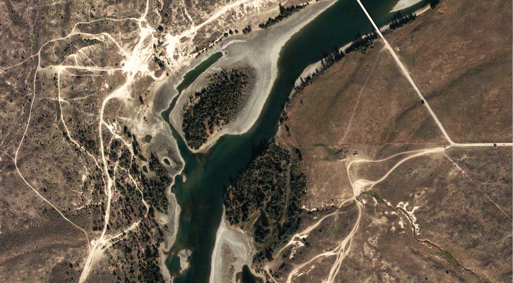
Giant Gravel Bars


Giant gravel bars along the lower Flathead River.
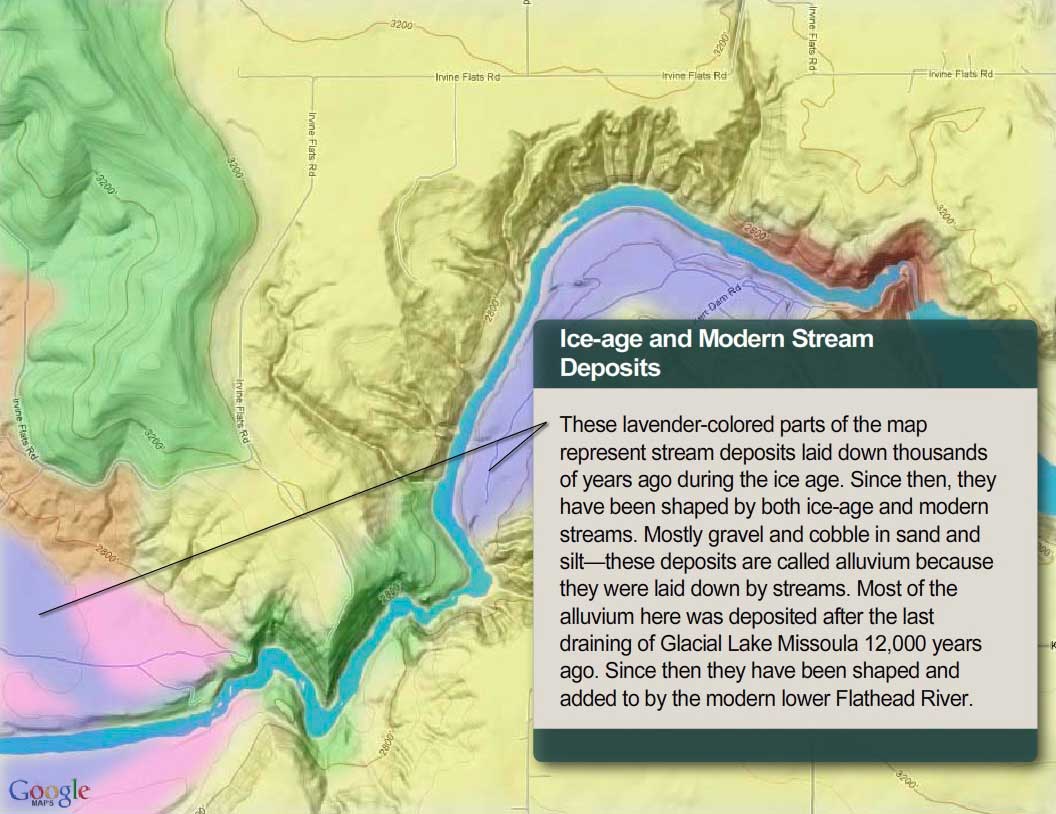
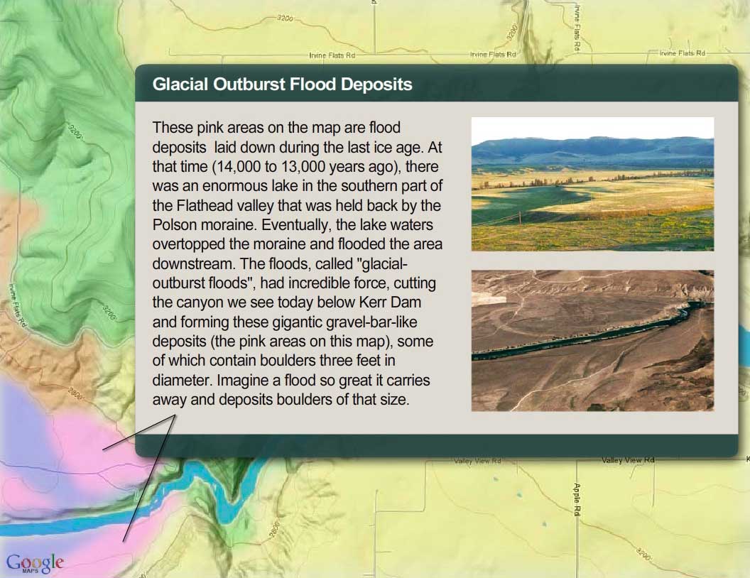
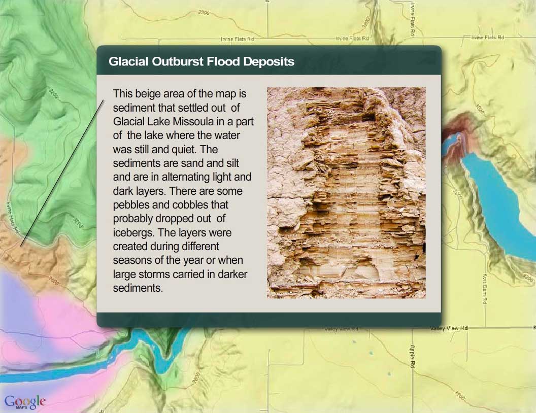
These giant gravel bars just below Buffalo Rapids formed during the last ice age in what are called "glacial outburst floods". The Flathead Lobe of an enormous ice sheet thousands of feet thick extended all the way down to where Kerr Dam is today. The floods, called jökulhlaups, were caused by melt water being released from the lobe of this glacial ice sheet.
Jökulhlaups are extreme flood events that occur when melting causes a sudden release of a huge amount of water from a glacier or an ice sheet. The floodwater comes from "over-pressurized" water released from underneath the glacier as well as water in glacially dammed lakes. During one of these events, water suddenly rushes forth like a Tsunami. In the process, it can create giant gravel bars similar to the ones you see in most rivers, except that those in normal rivers are much smaller. The ones created on the lower Flathead are 24 feet high and almost a mile long.
The photos at right show some modern giant gravel bars in Greenland that formed during extreme flood events or jökulhlaups. In the top right photo you can see a glacier in the upper left hand corner that, occasionally, releases huge quantities of water. The result is the giant gravel bars shown in the lower right photo. The giant gravel bars on the lower Flathead River are now covered with soil and grass, but you can easily imagine, by looking at the photos, what they looked like 12,000 years ago when they formed.


Modern giant gravel bars in Iceland
In the bottom right photo below, you can see just how high these giant gravel bars are (they are 24 feet high). Compare that with a gravel bar formed by normal river processes, which are usually two to four feet high. These giant floods had so much force that they probably played a big role in carving the canyon below Kerr Dam. Because we don't have large glaciers in Montana like were here during the ice age, these large gravel bars are no longer being formed.

Giant gravel bars along the lower Flathead River.


Giant gravel bars along the lower Flathead River. The bars are 24 feet high.

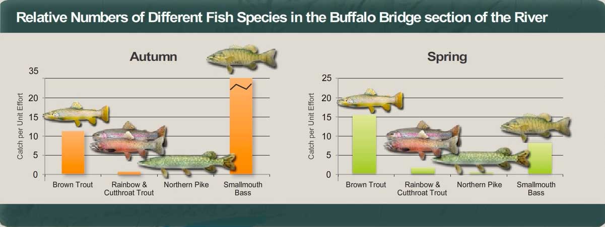
These charts show the numbers of fish caught per unit effort (the number of fish caught per hour by electrofishing), which in this study is a good measure of relative abundance of each species in the river. You can see that in the fall, smallmouth bass are by far the most abundant, but in spring their numbers drop and brown trout become the most abundant fish in this section of the river. What explanations can you give for why smallmouth bass populations are so different in spring and fall in this part of the river?
The answer is: Smallmouth bass in the lower Flathead River migrate seasonally between spawning habitats (found mostly in downstream areas) and overwintering habitats (found mostly in upstream areas like this stretch of the river). How far they go varies depending on the individual fish, but nearly one-third move farther than 37 miles. The farthest distance measured so far has been 60 miles. (Biologists implant radios in fish to measure their movements). The fish generally move to their spawning habitats in mid-April and early May and to their overwintering areas in mid to late July.
A Note on Electrofishing
The chart above shows the number of fish caught per hour using electrofishing. Electrofishing uses electricity to stun fish. Once stunned, the fish can be scooped up with a net. When done right, electrofishing does not harm fish. They return to their natural state in as little as two minutes after being stunned.
Electrofishing relies on two electrodes that deliver an electric current into the water. When a fish encounters the current, it has an uncontrolled muscular convulsion and is stunned. At least two people are required for an effective electrofishing crew: one to operate the electrode, the other to catch the stunned fish with a dip net.
Once the fish is caught, biologists quickly measure and weigh it. They take a scale to age it and sometimes use water to gently wash food from the stomach so they can study food habits. Sometimes they clip a fin so they can look at the fish's genetics. And before they let it go, they check for hook scars, and other indicators of the fish's health and history.
Off-Road Vehicle Use
Spoiling the Beauty
Driving off road is not cool. Tally the damage and you realize just how uncool it is. It damages soils, compacting them, making them less permeable to water and drying them out, making it more difficult for plants to live. It increases erosion, increasing sediment production and destroying fish habitat. It kills vegetation, crushing plants and seedlings. In arid environments like the river corridor, vegetation is more susceptible because plants in dry environments grow slowly and many have shallow root systems. It dramatically reduces the diversity of plant species and increases weeds. Wildlife suffers. And it ruins the beauty of the river corridor. No one likes to look at eroded hillsides and gullies caused by irresponsible people driving off roads. Plus it is illegal. People who drive off roads can receive significant fines and citations. Can you think of other problems that off road driving causes?

On this page you can start your journey in River Reach One, which runs from Se̓liš Ksanka Qĺispe̓ Dam to Buffalo Bridge. The river here averages 374 feet wide and has drops approximately 8 feet per mile. The first 3.7 miles are confined within a steep rocky canyon. In the canyon, the channel bottom is mostly a mixture of large-boulders and bedrock, and the river itself is characterized by deep pools and several sets of rapids. Outside of the canyon, the channel widens, and the bottom blends into a cobble-gravel veneer atop heavy clay. Here, the water moves in a smooth, fast flowing glide with two riffle areas. Use the map below to learn more about the geology, biology, and human history of the river by clicking on any of the map markers.

Riparian Vegetation
The term riparian vegetation refers to the plant habitats and communities along the river margins and its banks. Riparian zones are important because so many birds and mammals in western Montana depend on them.
The first tab is a map of riparian vegetation types in Reach One; the second shows a pie chart that displays the percentage of each of those types for the entire length of the river (all 72 miles).

Vegetation Type Descriptions
Click a type to learn more
- Juniper-only Forests
- Douglas-fir
- Juniper & Ponderosa Pine
- Ponderosa Pine Forests
- Paper Birch
- Riparian Shrub Communities
- Upland Shrub Communities
- Dry Herbaceous Communities
- Xeric Herbaceous Communities
- Black Cottonwood Forests
- Cultivated Land
- Marsh Communities
- Seasonally Inundated Mudflats and Gravel Bars
- Mixed Forest Communities
- Fire Occurence

Juniper-Only Forests
Salish: Punɫp
Kootenai: ʾakuk̓pⱡuⱡaⱡ
These forests, which make up about 1% of the river's riparian zone, often contain ponderosa pine.
Juniper varies from a bushy shrub to a tree 50-feet tall. The trunk is short and stout. The crown is generally dense, although the branches may become long, slender and drooping.
The wood has been used for lance shafts and bows, and the needles burned ceremonially. Tea can be made from the boughs and branches to treat colds.

Douglas-fir Forests
Salish: Cq̓ɫp
Kootenai: Ⱡu
Douglas-fir forests make up about 7% of the riparian zone. These forests often contain some ponderosa pine and Rocky Mountain juniper as well.
Douglas-fir is really not a fir at all. Many things about it are different than the true firs, especially the cones. Because of fire exclusion, this tree has greatly expanded its distribution. Shrubs in the understory include snowberry, Wood's rose, service-berry, Oregon-grape, ninebark, and ocean spray. Forbs include dandelion, common yarrow, spotted knapweed, and wild strawberry.


Juniper and Ponderosa Pine Forests
Salish: Punɫp / Sʔátq͏ʷɫp
Kootenai: ʾakukpⱡuⱡaⱡ / Himu
These two trees are found together throughout the river corridor, especially below Goose Bend. This type of vegetation makes up about 8% of the riparian zone.
Ponderosa Pine Forests
Salish: Sʔátq͏ʷɫp
Kootenai: Himu
Ponderosa pine, pure stands of which occupy about 1% of the river corridor's riparian zone, is the state tree of Montana. It is a very important tree for lumber, growing from 50 to 180 feet tall. On the river it is found by itself, but it also grows with black cotton-wood and juniper and dense shrubs, including red-osier dogwood, serviceberry, and Wood's rose.
It has three needles or sometimes two in each bundle and they are usually 4-7 inches long in tufts at the end of the branches. The cones are 3-6 inches long, broadly rounded at base, tapered to the tip, short and squat; bright green, becoming reddish brown as they get older and armed with small spines. The bark is dark on small trees, cinnamon-brown to orange-yellow, thick and broken into large, flat, irregular “jig-saw puzzle-shaped” plates on old trees.


Paper Birch
Paper birch, which occupies about 1% of the river corridor's riparian zone, grows 60 to 80 feet tall and cannot tolerate shade. It takes over areas after fires and was used in the past to make canoes and baskets.
The leaves are oval or ovate, 2-5 inches long and 1-2 inches wide, usually rounded at the base with the margins toothed. They are dark green and shiny above, yellow-green below.
The bark is creamy white, separating into thin, papery layers, and marked by long, narrow, horizontal, dark, corky lines. The inner bark is orange.
Riparian Shrub Communities
Riparian shrub communities, which occupy about 6% of the riparian zone in the river corridor, are often found near the high water mark along the river.
They most often include sandbar willow, red-osier dogwood, Douglas hawthorn, Wood's rose, western snowberry and Bebb's willow. Willow and dogwood are often found together, and rose is frequently found with hawthorne, dogwood, and snowberry.
Grasses frequently found include redtop bentgrass, reed canarygrass, fowl bluegrass, Kentucky bluegrass, and quackgrass.
Other plants in this community include Canada thistle, hemp dogbane, black medic, Canada goldenrod, loosestrife and poison ivy.
Upland Shrub Communities
Upland shrub communities, which occupy about 22% of the riparian zone in the river corridor, can be found both near the high water mark and a considerable distance inland and above the high water mark.
Shrubs found in upland communities include big sagebrush, rubber rabbitbrush, antelope bitterbrush, oceanspray, and serviceberry.
Bluebunch wheatgrass, cheatgrass, prairie junegrass (Koeleria cristata) and Kentucky bluegrass are the most common grasses, and fringed sagebrush, arrowleaf balsamroot, spotted knapweed, and mullein are the most common forbs.

Dry Herbaceous Communities
Dry herbaceous communities, which occupy about 8% of the river corridor, are often found on steep slopes and rocky banks adjacent to the river. Many of these sites are adjacent to the riparian zone; few are contained within it.
The community includes three types of subcommunities: western wheatgrass with Idaho fescue; bluebunch wheatgrass with rough fescue; and Kentucky bluegrass with quackgrass (this last one is found on disturbed sites). Redtop bentgrass and Canada thistle are found on many of these sites, as is spotted knapweed, common timothy, baltic rush, and prickly lettuce.

Xeric Herbaceous Communities
Xeric means extremely dry, and xeric herbaceous communities are the driest on the river. They are usually found farther from the riparian zone or are on especially fine and dry soils. The dominant species in this community are needle-and-thread grass with red threeawn grass, spotted knapweed, erect cinquefoil, and sand dropseed. Cheatgrass, fringed sagebrush, goatweed, and Kentucky bluegrass are also common.
Many of these species have been introduced, and some are troublesome weeds. Fringed sagebrush is an indicator of intensive cattle grazing, Many of these communities are obviously impacted by grazing and some appear to have been heavily grazed in the 1930's and never allowed to recover. These areas are not significantly impacted by water levels, but are used by geese because of their forage value and proximity to the river.

Black Cottonwood Forest
Salish: Mulš
Kootenai: Kanuⱡ mamaⱡ aqpiʾk
Black cottonwood forests occupy about 2% of the riparian zone of the river corridor. The tree grows up to 120 feet high. It is the largest of our cottonwoods. When mature, its trunk is often free of branches up to one-half its height. It has broad, oval-shaped crowns when grown in open sites. It grows on moist soils along streams and rivers. The leaves are 3-7 inches long and 3-4 inches wide; broad, rounded at base. The bark is smooth and greenish on young stems; becomes gray and sharply furrowed, 1 to 2 inches thick as the tree ages.
Because of the way Kerr Dam was operated for many decades (major reductions in peak flows and rapidly fluctuating water levels), there has generally been a tremendous loss of species like black cottonwood and sandbar willow, which pioneer flooded areas like gravel bars. At the same time species ponderosa pine and Rocky Mountain juniper have expanded.

Cultivated Land
Cultivated land includes pasture lands (lands grazed annually by livestock, alfalfa, grainfields, and lawns. By curtailing peak flows, Kerr Dam has "dewatered" much of the floodplain, and that has led to a tremendous conversion of the riparian vegetation to agricultural land. In addition. many of the wetter shrub types have been changed to herbaceous vegetation because of overgrazing of the riparian zone,
Marsh Communities
Marsh communities on the river can be classified as tall and short. Tall marshes are made up of common cattail, flowering rush, hardstem bulrush, and reed canarygrass. Dominant species in the short marsh include water horsetail, common spikerush, arrowroot, beaked sedge, marestail and a combination of jointed rush and slender spikerush.
Marsh communities are vulnerable to water level fluctuations, yet are critical feeding sites for numerous shorebirds and fish, as well as geese in the late spring.
It is likely that the diversity of marsh habitat was greater on the river before regulation of water levels.

Seasonally Inundated Mudflats and Gravel Bars
Gravel bars and mudflats are found throughout the river corridor. Because of the fluctuating water levels (in spring they are underwater and in fall they are exposed), these areas are, for the most part, unvegetated. Still they provide important habitat for shorebirds and waterfowl.
Mixed Forest Communities
Mixed forests are highly variable in the species they have, but birch and Douglas fir are common together, sometimes with black cottonwood, aspen, and/or Rocky Mountain maple as well. Black cottonwood and ponderosa pine are also frequently found together.
Because of the different species present, these forests are used by many wildlife species and have among the highest diversity of bird life.

Fire Occurrence
Areas within the Flathead River Corridor burned on average about once every 8.5 years prior to the days of fire suppression (the average was 8.5 years but actual fire frequency ranged between 5 to 25 years). Some of those fires were lit by Indian people to clear campsites and improve forage for horses and wildlife. The fires generally did not kill large, mature trees. They were brief, low intensity fires that burned mostly grass and shrubs.
It is difficult to control wildfires within the river corridor because the roads are poor and parts of the corridor don't have any roads. Fuels include grasses and native shrubs (sage and bitterbrush), and open stands of ponderosa pine and juniper. There are lots of important natural and cultural resources along the river, many of which benefit from frequent fires. Prescribed fire is the best way to assure protection and restoration of those resources.

Raptors in the Canyon

Segment One Geomorphology
(geomorphology refers to the study of the physical features of the surface of the earth and their relation to its geological structures)
In the first part of this segment, the river flows through a canyon. In this canyon, the river bottom is made up of boulders and outcrops of bedrock. Beyond the canyon, the river cuts through silt-and-clay deposits laid down in Glacial Lake Missoula. There, the bottom is mostly cobbles and gravel resting on top of clay. From the dam to Buffalo Bridge, the river drops almost 8 feet per mile and averages 374 feet wide. The reach contains the only whitewater found on the river and the deepest pools.


SéIiš Ksanka Ql̓ispé (SKQ) Dam
Brief Description
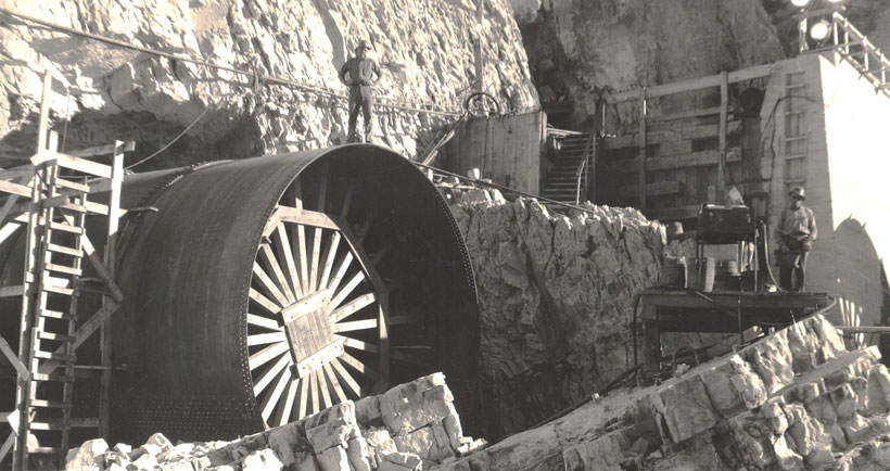
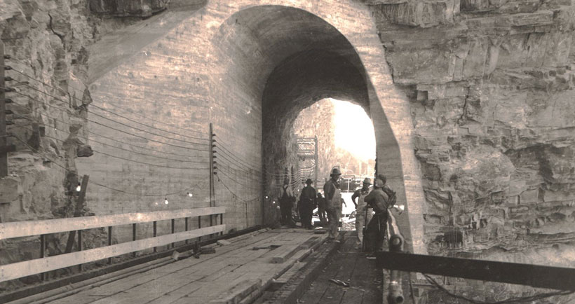
SKQ Dam is a three-generating-unit hydroelectric plant on the Flathead River about five miles southwest of Polson and the natural outlet of Flathead Lake. The units have a total generating capacity of 194 megawatts. One megawatt can satisfy the average energy needs of 750 households, so Kerr can supply enough energy to power 145,500 homes.
The dam, which began operation in 1938, is 541 feet long and 205 feet high. Its installation raised the level of Flathead Lake by 10 feet over the natural lake outlet. The dam’s 28-mile-long reservoir has a storage capacity of 1.2 million acre-feet. SKQ Dam is classified as a “storage generation” project because it uses the water stored in its reservoir to generate electricity.
The dam is owned and operated by the Confederated Salish and Kootenai Tribes, which took control of the dam in 2015.
The Dam's Impacts
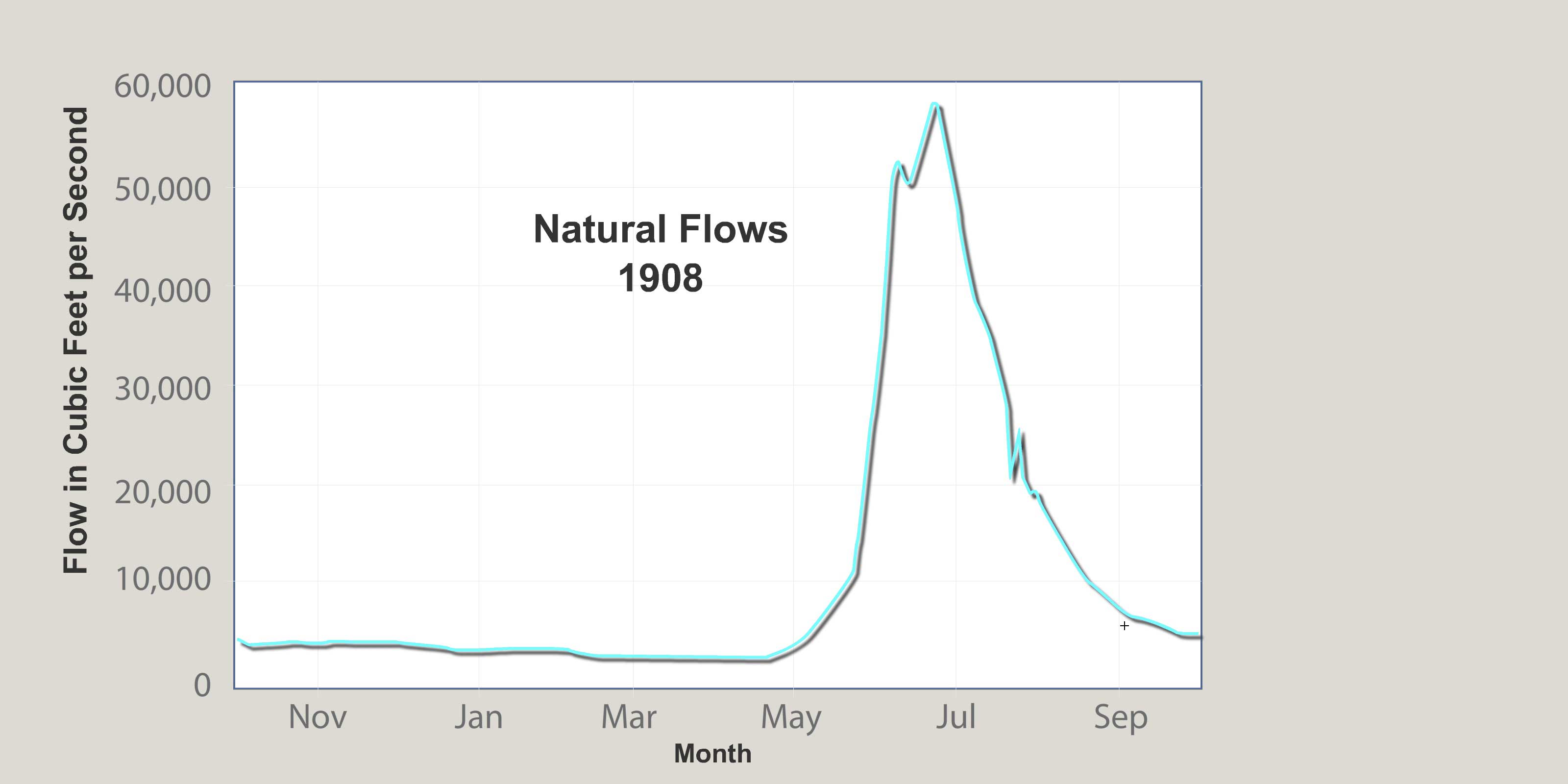
Water flows in the lower Flathead River are regulated by SKQ Dam and have been since the dam was completed in 1938. There is a stream gauge just below the dam that measures river flows over the course of a year. The hydrograph for the stream gauge shows the dam has reduced peak flows (flows in the spring) and increased winter flows.
These changes have caused the normally vegetated shoreline (what biologists call the varial zone) to become flooded in a way that would not occur with natural stream flows, and that does not allow riparian vegetation to exist where it normally would. This is especially true in the lower half of the river’s course. Many areas between the high and low water levels along this part of the river have become mostly unvegetated and instead are dominated by mud and rock.
Also, because the dam has for the most part ended flooding, it has shifted the species of trees growing along the river from deciduous species like cottonwood to conifers like ponderosa pine and juniper. Now conifers are the most common tree species found along the river.
In the past (from 1938 to the 1990s) the dam was operated so that flows fluctuated dramatically even over the course of a day. They were as unnatural as could be. Now the dam is operated so that flows are more natural, but still, floods are curtailed, and so the vegetation is not able to recover. It is still undergoing a long-term shift away from deciduous species and varial zones are not fully revegetated.


High and Low Water at SéIiš Ksanka Ql̓ispé (SKQ) Dam
The two images below (use the slider to compare them) show the difference between spring and fall flows at SKQ Dam. When the water is high and the lake has been filled, dam managers open the gates at the top of the dam. The turbines too are running at capacity at this time. In the summer, the gates close and flows through the dam drop, lowering flows in the river below the dam.
Discussion Questions:
- default_titleWhy do dam managers make sure Flathead Lake is full in the spring?
- default_titleIs letting so much water out in the spring good or bad for fish and wildlife downstream?
- default_titleWho decides when to close the gates and what goes into their decision?
- default_titleAre low flows in late summer and fall harmful to fish and wildlife?
- Show More
High and Low Water at Buffalo Rapids One & Two
The first seven miles below the dam are called "Buffalo Rapids." The river, flowing through the steep terrain of the canyon drops 8 feet per mile, the steepest drop of the river. Depending on current stream flows, several class III and IV rapids1 with sizeable waves and holes can exist. Kayaking and rafting is popular along the Buffalo Rapids reach. This section of the river offers good whitewater and the big waves and holes. At flows above 20,000 cfs, many of the rapids wash out, though powerful currents and suctions can be hazardous. Also, this river stretch becomes more difficult at low to moderate flows when large waves and holes develop and some sharp drops and rocks appear.
______________
1 CLASS III: Rapids with moderate, irregular waves that may be difficult to avoid. Large waves and strainers may be present, but are easily avoided. Swimming injuries rare. Suitable for those who do not mind getting a little wet, otherwise, same as class I and II.
CLASS IV rapids are defined as Intense, powerful, but predictable rapids requiring precise boat handling in turbulent water. May feature large, unavoidable waves and holes or constricted passages demanding fast maneuvers under pressure. Risk of injury to swimmers moderate to high, and water conditions may make self-rescue difficult. Suitable for those 12 and older, in good physical condition. With experienced guides, this level is recommended for first-timers as well as those with prior experience.
Buffalo Rapids One


Buffalo Rapids Two
Mule Deer: Eating and Being Eaten
A mountain lion will kill a deer every four to fourteen days. Mule deer have developed a unique escape behavior to deal with predators like mountain lions. It is called stotting: when they sense danger, they flee using a stifflegged bound (called a stott), bringing all four feet off the ground at the same time. A mule deer uses the leaps to bound up slopes and over bushes and rocks, making it difficult for predators to follow.
One mountain lion eats 1,125 pounds of venison each year. How many deer are needed to feed one mountain lion for a year if the deer average 150 pounds in weight?
One mule deer eats approximately 3,650 pounds of vegetation each year. One square mile of mule deer habitat produces 760 pounds of deer food each year. How many square miles of habitat are needed to support one mule deer?


Giant Gravel Bars

Giant gravel bars along the lower Flathead River.
These giant gravel bars just below Buffalo Rapids formed during the last ice age in what are called "glacial outburst floods". The Flathead Lobe of an enormous ice sheet thousands of feet thick extended all the way down to where Kerr Dam is today. The floods, called jökulhlaups, were caused by melt water being released from the lobe of this glacial ice sheet.
Jökulhlaups are extreme flood events that occur when melting causes a sudden release of a huge amount of water from a glacier or an ice sheet. The floodwater comes from "over-pressurized" water released from underneath the glacier as well as water in glacially dammed lakes. During one of these events, water suddenly rushes forth like a Tsunami. In the process, it can create giant gravel bars similar to the ones you see in most rivers, except that those in normal rivers are much smaller. The ones created on the lower Flathead are 24 feet high and almost a mile long.
The photos below show some modern giant gravel bars in Greenland that formed during extreme flood events or jökulhlaups. In the left photo you can see a glacier in the upper left hand corner that, occasionally, releases huge quantities of water. The result is the giant gravel bars shown in the lower right photo. The giant gravel bars on the lower Flathead River are now covered with soil and grass, but you can easily imagine, by looking at the photos, what they looked like 12,000 years ago when they formed.
Modern giant gravel bars in Iceland
In the bottom right photo below, you can see just how high these giant gravel bars are (they are 24 feet high). Compare that with a gravel bar formed by normal river processes, which are usually two to four feet high. These giant floods had so much force that they probably played a big role in carving the canyon below Kerr Dam. Because we don't have large glaciers in Montana like were here during the ice age, these large gravel bars are no longer being formed.
Giant gravel bars along the lower Flathead River.

Giant gravel bars along the lower Flathead River. The bars are 24 feet high.
These charts show the numbers of fish caught per unit effort (the number of fish caught per hour by electrofishing), which in this study is a good measure of relative abundance of each species in the river. You can see that in the fall, smallmouth bass are by far the most abundant, but in spring their numbers drop and brown trout become the most abundant fish in this section of the river. What explanations can you give for why smallmouth bass populations are so different in spring and fall in this part of the river?
The answer is: Smallmouth bass in the lower Flathead River migrate seasonally between spawning habitats (found mostly in downstream areas) and overwintering habitats (found mostly in upstream areas like this stretch of the river). How far they go varies depending on the individual fish, but nearly one-third move farther than 37 miles. The farthest distance measured so far has been 60 miles. (Biologists implant radios in fish to measure their movements). The fish generally move to their spawning habitats in mid-April and early May and to their overwintering areas in mid to late July.
A Note on Electrofishing
The chart above shows the number of fish caught per hour using electrofishing. Electrofishing uses electricity to stun fish. Once stunned, the fish can be scooped up with a net. When done right, electrofishing does not harm fish. They return to their natural state in as little as two minutes after being stunned.
Electrofishing relies on two electrodes that deliver an electric current into the water. When a fish encounters the current, it has an uncontrolled muscular convulsion and is stunned. At least two people are required for an effective electrofishing crew: one to operate the electrode, the other to catch the stunned fish with a dip net.
Once the fish is caught, biologists quickly measure and weigh it. They take a scale to age it and sometimes use water to gently wash food from the stomach so they can study food habits. Sometimes they clip a fin so they can look at the fish's genetics. And before they let it go, they check for hook scars, and other indicators of the fish's health and history.
Off-Road Vehicle Use
Spoiling the Beauty
Driving off road is not cool. Tally the damage and you realize just how uncool it is. It damages soils, compacting them, making them less permeable to water and drying them out, making it more difficult for plants to live. It increases erosion, increasing sediment production and destroying fish habitat. It kills vegetation, crushing plants and seedlings. In arid environments like the river corridor, vegetation is more susceptible because plants in dry environments grow slowly and many have shallow root systems. It dramatically reduces the diversity of plant species and increases weeds. Wildlife suffers. And it ruins the beauty of the river corridor. No one likes to look at eroded hillsides and gullies caused by irresponsible people driving off roads. Plus it is illegal. People who drive off roads can receive significant fines and citations. Can you think of other problems that off road driving causes?
Reach One
On this page you can start your journey in River Reach One, which runs from Se̓liš Ksanka Qĺispe̓ Dam to Buffalo Bridge. The river here averages 374 feet wide and has drops approximately 8 feet per mile. The first 3.7 miles are confined within a steep rocky canyon. In the canyon, the channel bottom is mostly a mixture of large-boulders and bedrock, and the river itself is characterized by deep pools and several sets of rapids. Outside of the canyon, the channel widens, and the bottom blends into a cobble-gravel veneer atop heavy clay. Here, the water moves in a smooth, fast flowing glide with two riffle areas. Use the map below to learn more about the geology, biology, and human history of the river by clicking on any of the map markers.

Riparian Vegetation
The term riparian vegetation refers to the plant habitats and communities along the river margins and its banks. Riparian zones are important because so many birds and mammals in western Montana depend on them.
The first tab is a map of riparian vegetation types in Reach One; the second shows a pie chart that displays the percentage of each of those types for the entire length of the river (all 72 miles).

Vegetation Type Descriptions
Click a type to learn more
- Juniper-only Forests
- Douglas-fir
- Juniper & Ponderosa Pine
- Ponderosa Pine Forests
- Paper Birch
- Riparian Shrub Communities
- Upland Shrub Communities
- Dry Herbaceous Communities
- Xeric Herbaceous Communities
- Black Cottonwood Forests
- Cultivated Land
- Marsh Communities
- Seasonally Inundated Mudflats and Gravel Bars
- Mixed Forest Communities
- Fire Occurence
Juniper-Only Forests
Salish: Punɫp
Kootenai: ʾakuk̓pⱡuⱡaⱡ
These forests, which make up about 1% of the river's riparian zone, often contain ponderosa pine.
Juniper varies from a bushy shrub to a tree 50-feet tall. The trunk is short and stout. The crown is generally dense, although the branches may become long, slender and drooping.
The wood has been used for lance shafts and bows, and the needles burned ceremonially. Tea can be made from the boughs and branches to treat colds.


Douglas-fir Forests
Salish: Cq̓ɫp
Kootenai: Ⱡu
Douglas-fir forests make up about 7% of the riparian zone. These forests often contain some ponderosa pine and Rocky Mountain juniper as well.
Douglas-fir is really not a fir at all. Many things about it are different than the true firs, especially the cones. Because of fire exclusion, this tree has greatly expanded its distribution. Shrubs in the understory include snowberry, Wood's rose, service-berry, Oregon-grape, ninebark, and ocean spray. Forbs include dandelion, common yarrow, spotted knapweed, and wild strawberry.


Juniper and Ponderosa Pine Forests
Salish: Punɫp / Sʔátq͏ʷɫp
Kootenai: ʾakukpⱡuⱡaⱡ / Himu
These two trees are found together throughout the river corridor, especially below Goose Bend. This type of vegetation makes up about 8% of the riparian zone.


Ponderosa Pine Forests
Salish: Sʔátq͏ʷɫp
Kootenai: Himu
Ponderosa pine, pure stands of which occupy about 1% of the river corridor's riparian zone, is the state tree of Montana. It is a very important tree for lumber, growing from 50 to 180 feet tall. On the river it is found by itself, but it also grows with black cotton-wood and juniper and dense shrubs, including red-osier dogwood, serviceberry, and Wood's rose.
It has three needles or sometimes two in each bundle and they are usually 4-7 inches long in tufts at the end of the branches. The cones are 3-6 inches long, broadly rounded at base, tapered to the tip, short and squat; bright green, becoming reddish brown as they get older and armed with small spines. The bark is dark on small trees, cinnamon-brown to orange-yellow, thick and broken into large, flat, irregular “jig-saw puzzle-shaped” plates on old trees.


Paper Birch
Paper birch, which occupies about 1% of the river corridor's riparian zone, grows 60 to 80 feet tall and cannot tolerate shade. It takes over areas after fires and was used in the past to make canoes and baskets.
The leaves are oval or ovate, 2-5 inches long and 1-2 inches wide, usually rounded at the base with the margins toothed. They are dark green and shiny above, yellow-green below.
The bark is creamy white, separating into thin, papery layers, and marked by long, narrow, horizontal, dark, corky lines. The inner bark is orange.

Riparian Shrub Communities
Riparian shrub communities, which occupy about 6% of the riparian zone in the river corridor, are often found near the high water mark along the river.
They most often include sandbar willow, red-osier dogwood, Douglas hawthorn, Wood's rose, western snowberry and Bebb's willow. Willow and dogwood are often found together, and rose is frequently found with hawthorne, dogwood, and snowberry.
Grasses frequently found include redtop bentgrass, reed canarygrass, fowl bluegrass, Kentucky bluegrass, and quackgrass.
Other plants in this community include Canada thistle, hemp dogbane, black medic, Canada goldenrod, loosestrife and poison ivy.

Upland Shrub Communities
Upland shrub communities, which occupy about 22% of the riparian zone in the river corridor, can be found both near the high water mark and a considerable distance inland and above the high water mark.
Shrubs found in upland communities include big sagebrush, rubber rabbitbrush, antelope bitterbrush, oceanspray, and serviceberry.
Bluebunch wheatgrass, cheatgrass, prairie junegrass (Koeleria cristata) and Kentucky bluegrass are the most common grasses, and fringed sagebrush, arrowleaf balsamroot, spotted knapweed, and mullein are the most common forbs.

Dry Herbaceous Communities
Dry herbaceous communities, which occupy about 8% of the river corridor, are often found on steep slopes and rocky banks adjacent to the river. Many of these sites are adjacent to the riparian zone; few are contained within it.
The community includes three types of subcommunities: western wheatgrass with Idaho fescue; bluebunch wheatgrass with rough fescue; and Kentucky bluegrass with quackgrass (this last one is found on disturbed sites). Redtop bentgrass and Canada thistle are found on many of these sites, as is spotted knapweed, common timothy, baltic rush, and prickly lettuce.
Xeric Herbaceous Communities
Xeric means extremely dry, and xeric herbaceous communities are the driest on the river. They are usually found farther from the riparian zone or are on especially fine and dry soils. The dominant species in this community are needle-and-thread grass with red threeawn grass, spotted knapweed, erect cinquefoil, and sand dropseed. Cheatgrass, fringed sagebrush, goatweed, and Kentucky bluegrass are also common.
Many of these species have been introduced, and some are troublesome weeds. Fringed sagebrush is an indicator of intensive cattle grazing, Many of these communities are obviously impacted by grazing and some appear to have been heavily grazed in the 1930's and never allowed to recover. These areas are not significantly impacted by water levels, but are used by geese because of their forage value and proximity to the river.
Black Cottonwood Forest
Salish: Mulš
Kootenai: Kanuⱡ mamaⱡ aqpiʾk
Black cottonwood forests occupy about 2% of the riparian zone of the river corridor. The tree grows up to 120 feet high. It is the largest of our cottonwoods. When mature, its trunk is often free of branches up to one-half its height. It has broad, oval-shaped crowns when grown in open sites. It grows on moist soils along streams and rivers. The leaves are 3-7 inches long and 3-4 inches wide; broad, rounded at base. The bark is smooth and greenish on young stems; becomes gray and sharply furrowed, 1 to 2 inches thick as the tree ages.
Because of the way Kerr Dam was operated for many decades (major reductions in peak flows and rapidly fluctuating water levels), there has generally been a tremendous loss of species like black cottonwood and sandbar willow, which pioneer flooded areas like gravel bars. At the same time species ponderosa pine and Rocky Mountain juniper have expanded.

Cultivated Land
Cultivated land includes pasture lands (lands grazed annually by livestock, alfalfa, grainfields, and lawns. By curtailing peak flows, Kerr Dam has "dewatered" much of the floodplain, and that has led to a tremendous conversion of the riparian vegetation to agricultural land. In addition. many of the wetter shrub types have been changed to herbaceous vegetation because of overgrazing of the riparian zone,

Marsh Communities
Marsh communities on the river can be classified as tall and short. Tall marshes are made up of common cattail, flowering rush, hardstem bulrush, and reed canarygrass. Dominant species in the short marsh include water horsetail, common spikerush, arrowroot, beaked sedge, marestail and a combination of jointed rush and slender spikerush.
Marsh communities are vulnerable to water level fluctuations, yet are critical feeding sites for numerous shorebirds and fish, as well as geese in the late spring.
It is likely that the diversity of marsh habitat was greater on the river before regulation of water levels.

Seasonally Inundated Mudflats and Gravel Bars
Gravel bars and mudflats are found throughout the river corridor. Because of the fluctuating water levels (in spring they are underwater and in fall they are exposed), these areas are, for the most part, unvegetated. Still they provide important habitat for shorebirds and waterfowl.

Mixed Forest Communities
Mixed forests are highly variable in the species they have, but birch and Douglas fir are common together, sometimes with black cottonwood, aspen, and/or Rocky Mountain maple as well. Black cottonwood and ponderosa pine are also frequently found together.
Because of the different species present, these forests are used by many wildlife species and have among the highest diversity of bird life.
Fire Occurrence
Areas within the Flathead River Corridor burned on average about once every 8.5 years prior to the days of fire suppression (the average was 8.5 years but actual fire frequency ranged between 5 to 25 years). Some of those fires were lit by Indian people to clear campsites and improve forage for horses and wildlife. The fires generally did not kill large, mature trees. They were brief, low intensity fires that burned mostly grass and shrubs.
It is difficult to control wildfires within the river corridor because the roads are poor and parts of the corridor don't have any roads. Fuels include grasses and native shrubs (sage and bitterbrush), and open stands of ponderosa pine and juniper. There are lots of important natural and cultural resources along the river, many of which benefit from frequent fires. Prescribed fire is the best way to assure protection and restoration of those resources.
Raptors in the Canyon

Segment One Geomorphology
(geomorphology refers to the study of the physical features of the surface of the earth and their relation to its geological structures)
In the first part of this segment, the river flows through a canyon. In this canyon, the river bottom is made up of boulders and outcrops of bedrock. Beyond the canyon, the river cuts through silt-and-clay deposits laid down in Glacial Lake Missoula. There, the bottom is mostly cobbles and gravel resting on top of clay. From the dam to Buffalo Bridge, the river drops almost 8 feet per mile and averages 374 feet wide. The reach contains the only whitewater found on the river and the deepest pools.


SéIiš Ksanka Ql̓ispé (SKQ) Dam
Brief Description
SKQ Dam is a three-generating-unit hydroelectric plant on the Flathead River about five miles southwest of Polson and the natural outlet of Flathead Lake. The units have a total generating capacity of 194 megawatts. One megawatt can satisfy the average energy needs of 750 households, so Kerr can supply enough energy to power 145,500 homes.
The dam, which began operation in 1938, is 541 feet long and 205 feet high. Its installation raised the level of Flathead Lake by 10 feet over the natural lake outlet. The dam’s 28-mile-long reservoir has a storage capacity of 1.2 million acre-feet. SKQ Dam is classified as a “storage generation” project because it uses the water stored in its reservoir to generate electricity.
The dam is owned and operated by the Confederated Salish and Kootenai Tribes, which took control of the dam in 2015.
The Dam's Impacts
Water flows in the lower Flathead River are regulated by SKQ Dam and have been since the dam was completed in 1938. There is a stream gauge just below the dam that measures river flows over the course of a year. The hydrograph for the stream gauge shows the dam has reduced peak flows (flows in the spring) and increased winter flows.
These changes have caused the normally vegetated shoreline (what biologists call the varial zone) to become flooded in a way that would not occur with natural stream flows, and that does not allow riparian vegetation to exist where it normally would. This is especially true in the lower half of the river’s course. Many areas between the high and low water levels along this part of the river have become mostly unvegetated and instead are dominated by mud and rock.
Also, because the dam has for the most part ended flooding, it has shifted the species of trees growing along the river from deciduous species like cottonwood to conifers like ponderosa pine and juniper. Now conifers are the most common tree species found along the river.
In the past (from 1938 to the 1990s) the dam was operated so that flows fluctuated dramatically even over the course of a day. They were as unnatural as could be. Now the dam is operated so that flows are more natural, but still, floods are curtailed, and so the vegetation is not able to recover. It is still undergoing a long-term shift away from deciduous species and varial zones are not fully revegetated.


High and Low Water at SéIiš Ksanka Ql̓ispé (SKQ) Dam
The two images below (use the slider to compare them) show the difference between spring and fall flows at SKQ Dam. When the water is high and the lake has been filled, dam managers open the gates at the top of the dam. The turbines too are running at capacity at this time. In the summer, the gates close and flows through the dam drop, lowering flows in the river below the dam.
Discussion Questions:
- default_titleWhy do dam managers make sure Flathead Lake is full in the spring?
- default_titleIs letting so much water out in the spring good or bad for fish and wildlife downstream?
- default_titleWho decides when to close the gates and what goes into their decision?
- default_titleAre low flows in late summer and fall harmful to fish and wildlife?
- Show More


High and Low Water at Buffalo Rapids One & Two
The first seven miles below the dam are called "Buffalo Rapids." The river, flowing through the steep terrain of the canyon drops 8 feet per mile, the steepest drop of the river. Depending on current stream flows, several class III and IV rapids1 with sizeable waves and holes can exist. Kayaking and rafting is popular along the Buffalo Rapids reach. This section of the river offers good whitewater and the big waves and holes. At flows above 20,000 cfs, many of the rapids wash out, though powerful currents and suctions can be hazardous. Also, this river stretch becomes more difficult at low to moderate flows when large waves and holes develop and some sharp drops and rocks appear.
______________
1 CLASS III: Rapids with moderate, irregular waves that may be difficult to avoid. Large waves and strainers may be present, but are easily avoided. Swimming injuries rare. Suitable for those who do not mind getting a little wet, otherwise, same as class I and II.
CLASS IV rapids are defined as Intense, powerful, but predictable rapids requiring precise boat handling in turbulent water. May feature large, unavoidable waves and holes or constricted passages demanding fast maneuvers under pressure. Risk of injury to swimmers moderate to high, and water conditions may make self-rescue difficult. Suitable for those 12 and older, in good physical condition. With experienced guides, this level is recommended for first-timers as well as those with prior experience.
Buffalo Rapids One

Buffalo Rapids Two


Mule Deer: Eating and Being Eaten

A mountain lion will kill a deer every four to fourteen days. Mule deer have developed a unique escape behavior to deal with predators like mountain lions. It is called stotting: when they sense danger, they flee using a stifflegged bound (called a stott), bringing all four feet off the ground at the same time. A mule deer uses the leaps to bound up slopes and over bushes and rocks, making it difficult for predators to follow.
One mountain lion eats 1,125 pounds of venison each year. How many deer are needed to feed one mountain lion for a year if the deer average 150 pounds in weight?
One mule deer eats approximately 3,650 pounds of vegetation each year. One square mile of mule deer habitat produces 760 pounds of deer food each year. How many square miles of habitat are needed to support one mule deer?


Giant Gravel Bars
These giant gravel bars just below Buffalo Rapids formed during the last ice age in what are called "glacial outburst floods". The Flathead Lobe of an enormous ice sheet thousands of feet thick extended all the way down to where Kerr Dam is today. The floods, called jökulhlaups, were caused by melt water being released from the lobe of this glacial ice sheet.
Jökulhlaups are extreme flood events that occur when melting causes a sudden release of a huge amount of water from a glacier or an ice sheet. The floodwater comes from "over-pressurized" water released from underneath the glacier as well as water in glacially dammed lakes. During one of these events, water suddenly rushes forth like a Tsunami. In the process, it can create giant gravel bars similar to the ones you see in most rivers, except that those in normal rivers are much smaller. The ones created on the lower Flathead are 24 feet high and almost a mile long.
The photos at right (below) show some modern giant gravel bars in Greenland that formed during extreme flood events or jökulhlaups. In the top right photo you can see a glacier in the upper left hand corner that, occasionally, releases huge quantities of water. The result is the giant gravel bars shown in the lower right photo. The giant gravel bars on the lower Flathead River are now covered with soil and grass, but you can easily imagine, by looking at the photos, what they looked like 12,000 years ago when they formed.

Giant gravel bars along the lower Flathead River.


Modern giant gravel bars in Iceland
In the bottom right photo below, you can see just how high these giant gravel bars are (they are 24 feet high). Compare that with a gravel bar formed by normal river processes, which are usually two to four feet high. These giant floods had so much force that they probably played a big role in carving the canyon below Kerr Dam. Because we don't have large glaciers in Montana like were here during the ice age, these large gravel bars are no longer being formed.

Giant gravel bars along the lower Flathead River.

Giant gravel bars along the lower Flathead River. The bars are 24 feet high.

These charts show the numbers of fish caught per unit effort (the number of fish caught per hour by electrofishing), which in this study is a good measure of relative abundance of each species in the river. You can see that in the fall, smallmouth bass are by far the most abundant, but in spring their numbers drop and brown trout become the most abundant fish in this section of the river. What explanations can you give for why smallmouth bass populations are so different in spring and fall in this part of the river?
The answer is: Smallmouth bass in the lower Flathead River migrate seasonally between spawning habitats (found mostly in downstream areas) and overwintering habitats (found mostly in upstream areas like this stretch of the river). How far they go varies depending on the individual fish, but nearly one-third move farther than 37 miles. The farthest distance measured so far has been 60 miles. (Biologists implant radios in fish to measure their movements). The fish generally move to their spawning habitats in mid-April and early May and to their overwintering areas in mid to late July.
A Note on Electrofishing
The chart above shows the number of fish caught per hour using electrofishing. Electrofishing uses electricity to stun fish. Once stunned, the fish can be scooped up with a net. When done right, electrofishing does not harm fish. They return to their natural state in as little as two minutes after being stunned.
Electrofishing relies on two electrodes that deliver an electric current into the water. When a fish encounters the current, it has an uncontrolled muscular convulsion and is stunned. At least two people are required for an effective electrofishing crew: one to operate the electrode, the other to catch the stunned fish with a dip net.
Once the fish is caught, biologists quickly measure and weigh it. They take a scale to age it and sometimes use water to gently wash food from the stomach so they can study food habits. Sometimes they clip a fin so they can look at the fish's genetics. And before they let it go, they check for hook scars, and other indicators of the fish's health and history.
Off-Road Vehicle Use
Spoiling the Beauty
Driving off road is not cool. Tally the damage and you realize just how uncool it is. It damages soils, compacting them, making them less permeable to water and drying them out, making it more difficult for plants to live. It increases erosion, increasing sediment production and destroying fish habitat. It kills vegetation, crushing plants and seedlings. In arid environments like the river corridor, vegetation is more susceptible because plants in dry environments grow slowly and many have shallow root systems. It dramatically reduces the diversity of plant species and increases weeds. Wildlife suffers. And it ruins the beauty of the river corridor. No one likes to look at eroded hillsides and gullies caused by irresponsible people driving off roads. Plus it is illegal. People who drive off roads can receive significant fines and citations. Can you think of other problems that off road driving causes?

© 2021 Confederated Salish and Kootenai Tribes | Contact Us
© 2021 Confederated Salish and Kootenai Tribes | Contact Us